|
|
 |
Chesapeake Bay Watershed Region (short version)
|
|
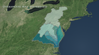
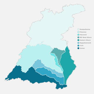
The watershed that drains into the Chesapeake Bay is a huge expanse that extends 64,000 miles into five states across North America (New York, Pensylvania, Maryland, Delaware, Virginia) and the District of Columbia. This visualization overlays the full watershed onto a Landsat satellite visualization of the Bay area. The eight different distinctly colored regions indicate the Chesapeake's major subwatersheds. These subwatershed regions are: Susquehanna, Potomac, Patuxent, MD West Shore, Rapahhannock, Eastern Shore, James and York. This visualization contains just the last part of the Chesapeake Bay Flyover and Watershed Region (#3472) animation and demonstrates the entire Watershed without the Chesapeake Bay flyover. This animation highlights and labels each subwatershed in turn.
|
|
|
|
Chesapeake Bay Watershed and sub watershed regions
Duration: 44.0 seconds
Available formats:
1280x720 (30 fps)
MPEG-4
2 MB
640x360 (30 fps)
MPEG-4
1 MB
512x288 (30 fps)
MPEG-1
5 MB
1280x720 (30 fps)
MPEG-2
25 MB
1280x720 (30 fps)
Frames
1280x720 (60 fps)
Frames
1280x720
TIFF
3 MB
320x180
PNG
88 KB
160x80
PNG
72 KB
80x40
PNG
24 KB
How to play our movies
|
|
|
|
Image: Chesapeake Bay Watershed and subwatershed regions (Susquehanna, Potomac, Patuxent, MD West Shore, Rapahhannock, Eastern Shore, James, York)
Latitude (min, max) =(36.92, 43.26)
Longitude (min, max)=(73.93, 80.87)
Available formats:
5000 x 5000
TIFF
1 MB
2500 x 2500
TIFF
876 KB
1500 x 1500
TIFF
424 KB
320 x 320
PNG
62 KB
|
| Animation Number: | 3477 |
| Animators: | Helen-Nicole Kostis (SVS) (Lead) |
| | Cindy Starr (SVS) |
| | Jeff de La Beaujardiere (SVS) |
| | Greg Shirah (SVS) |
| Completed: | 2007-10-11 |
| Producer: | Andy Freeberg (NASA/GSFC) |
| Scientists: | Darrel Williams (NASA/GSFC) |
| | Laura Rocchio (SSAI) |
| Instrument: | Landsat-7/ETM+ |
| Data Collected: | The mosaic was created by EarthSat under contract with NASA as part of the GeoCover 2000 product. All images used in GeoCover were acquired by Landsat 7 during the period of 1999-2002. The pixel size of the full resolution image represents 14.25 m on the ground. The Chesapeake Bay mosaic uses portions of eight Landsat-7 scenes. Below you will find a listing of the eight Landsat 7 images that were put together to create the composite image. Landsat scenes are organized by a Path and Row number according to the Worldwide Reference System. (To learn more about Landsat's Worldwide Reference System, please visit: http://landsat.gsfc.nasa.gov/about/wrs.html)
Scenes used in the Chesapeake Bay mosaic:
Landsat 7 WRS Path 15-Row 32 acquired on Oct. 05, 2001
Landsat 7 WRS Path 14-Row 32 acquired on Sept. 23, 1999
Landsat 7 WRS Path 15-Row 33 acquired on October 05, 2001
Landsat 7 WRS Path 14-Row 33 acquired on July 10, 2001
Landsat 7 WRS Path 15-Row 34 acquired on Sept. 30, 1999
Landsat 7 WRS Path 14-Row 34 acquired on July 10, 2001
Landsat 7 WRS Path 15-Row 35 acquired on Sept. 30, 1999
Landsat 7 WRS Path 14-Row 35 acquired on Sept. 23, 1999 |
| Series: | Chesapeake Bay |
| Goddard TV Tape: | G2008-034HD -- NASAs HD Chesapeake Bay Resource Tape |
Keywords:
SVS
>> Chesapeake Bay
SVS
>> Flyover
SVS
>> HDTV
SVS
>> Landsat
GCMD
>> EARTH SCIENCE
|
|
Please give credit for this item to
NASA/Goddard Space Flight Center Scientific Visualization Studio |
|
Back to Top
|
|
|
|

