MAP '05 Models Hurricane Katrina's Winds from August 23, 2005 through August 31, 2005
|
During the summer of 2005, the Earth-Sun Exploration Division of NASA/Goddard Space Flight Center(GSFC) brought together resources from NASA to study tropical cyclones. The MAP '05 Project, so named for its affiliation with NASA's Modeling, Analysis, and Prediction (MAP) program, applies NASA's advanced satellite remote sensing technologies and earth system modeling capabilities to improve our understanding of tropical cyclones that develop in and move across the Atlantic basin. MAP '05 implemented the most recent version of the NASA/Goddard Earth Observing System (GEOS) fifth-generation global atmospheric model and the Gridpoint Statistical Interpolation (GSI) analysis system under development as a collaboration between NOAA's National Centers for Environmental Prediction (NCEP) and the Global Modeling and Assimilation Office (GMAO) at GSFC. This animation displays MAP '05's wind analysis data for every 6 hour interval from August 23 through August 31, 2005.
|
|
|
|
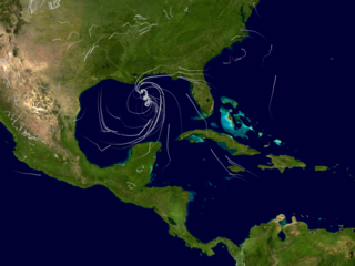
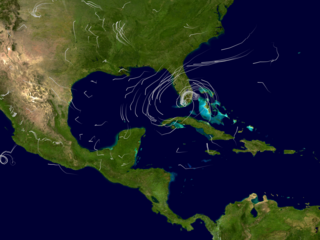
The animation shows the wind analysis data from August 23 through 31, 2005 from NASA's Modeling, Analysis and Prediciton Program 2005. This preview image shows Hurricane Katrina's winds just before landfall on August 29, 2005. At this point, the storm has sustained winds near 145 mph.
Duration: 26.0 seconds
Available formats:
2560x1920
TIFF
4 MB
720x486 (29.97 fps)
Frames
320x240
PNG
88 KB
160x80
PNG
15 KB
80x40
PNG
4 KB
720x480 (29.97 fps)
MPEG-2
21 MB
640x480 (29.97 fps)
MPEG-4
7 MB
640x480 (29.97 fps)
MPEG-1
10 MB
320x240 (29.97 fps)
MPEG-1
3 MB
How to play our movies
|
|
|
|
August 24, 2005. Tropical Storm Katrina forms over the Bahamas packing sustained winds of 46.1 mph.
Available formats:
2560 x 1920
TIFF
4 MB
320 x 240
PNG
90 KB
|
|
|
|
August 25, 2005
Tropical Storm Katrina had strengthened just before making landfall in Florida. It is now packing sustained winds of 57.6 mph.
Available formats:
2560 x 1920
TIFF
4 MB
320 x 240
PNG
89 KB
|
|

|
|
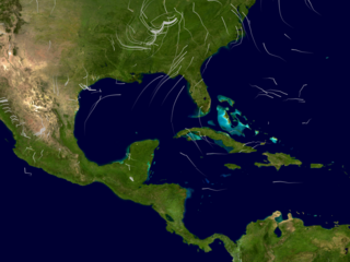
August 26, 2005 - The storm continues to strengthen as it moves west of Florida into the Gulf of Mexico. It is officially classified as a Hurricane 1. It has sustained winds of 74.9 mph.
Available formats:
2560 x 1920
TIFF
4 MB
320 x 240
PNG
89 KB
|
|

|
|
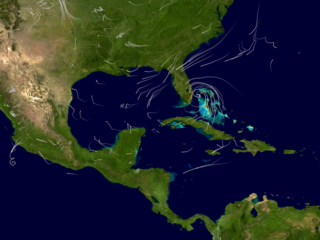
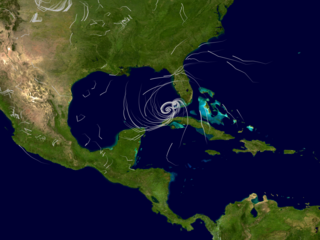
August 27, 2005 - The storm continues to strengthen. It is classified as a category 2 Hurricane with sustained winds of 109.4 mph.
Available formats:
2560 x 1920
TIFF
4 MB
320 x 240
PNG
88 KB
|
|

|
|
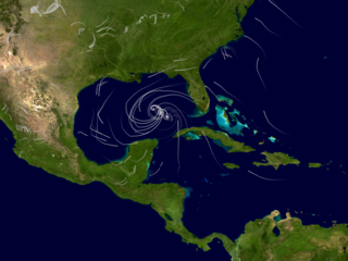
August 28, 2005 - At this point the storm is classified as the most deadly Category 5. Sustained winds of 161mph were recorded.
Available formats:
2560 x 1920
TIFF
4 MB
320 x 240
PNG
90 KB
|
|

|
|
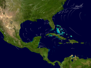
August 30, 2005 - At this point, Katrina is classified as a tropical storm with sustained winds of 51.8 mph.
Available formats:
2560 x 1920
TIFF
4 MB
320 x 240
PNG
87 KB
|
|
|
|
August 31, 2005 - Katrina is now classified as a Tropical Depression with winds of 28.8 mph.
Available formats:
2560 x 1920
TIFF
4 MB
320 x 240
PNG
88 KB
|
|
|
Back to Top
|

