|
|
 |
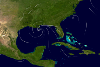
MAP '05 Models Hurricane Katrina's Winds on August 29, 2005
|
During the summer of 2005 the Earth-Sun Exploration Division of NASA/Goddard Space Flight Center(GSFC) brought together resources from NASA to study tropical cyclones. The MAP '05 Project, so named for its affiliation with NASA's Modeling, Analysis, and Prediction (MAP) program, applies NASA's advanced satellite remote sensing technologies and earth system modeling capabilities to improve our understanding of tropical cyclones that develop in and move across the Atlantic basin. MAP '05 implemented the most recent version of the NASA/Goddard Earth Observing System (GEOS) fifth-generation global atmospheric model and the Gridpoint Statistical Interpolation (GSI) analysis system under development as a collaboration between NOAA's National Centers for Environmental Prediction (NCEP) and the Global Modeling and Assimilation Office (GMAO) at GSFC. This animation generates a white static flow fields from the MAP '05 wind analysis data.
|
|
|
|
August 29, 2005 at 06Zulu. Hurricane Katrina was classified as a Category 4 hurricane with sustained winds of 155 mph.
Duration: 17.0 seconds
Available formats:
720x486 (29.97 fps)
Frames
720x480 (29.97 fps)
MPEG-2
14 MB
320x216
PNG
82 KB
160x80
PNG
18 KB
80x40
PNG
5 KB
640x480 (29.97 fps)
MPEG-4
2 MB
640x480 (29.97 fps)
MPEG-1
4 MB
320x240 (29.97 fps)
MPEG-1
1 MB
How to play our movies
|
|
|
Back to Top
|
|
|
|

