Aqua MODIS Ocean Color Swath during Hurricane Katrina
|
|
The Aqua satellite orbits the Earth every 99 minutes in a polar, sun-synchronous orbit. The MODIS instrument on Aqua observes reflected light from the Earth in 36 spectral frequencies. These observations can be processed to show many properties of the Earth's surface, from temperature and phytoplankton measurements near the surface of the ocean to fire occurrences and land cover characteristics on the land surface. This animation shows MODIS ocean color data from about 4 days of individual Aqua orbits. Ocean color is a measurement of the amount of chlorophyll in ocean phytoplankton and is therefore a direct measurement of the amount of life in the ocean. It can only be measured in ocean regions that are free of both clouds and sun glint, the bright band of specular reflection in the center of each granule.
|
|

|
|
Four days of Aqua MODIS ocean color swaths during the period of Hurricane Katrina, from August 27, 2005 through August 30, 2005.
Duration: 20.0 seconds
Available formats:
1024x512 (25 fps)
MPEG-1
1 MB
1024x512
Frames
320x160
PNG
5 KB
160x80
PNG
1 KB
80x40
PNG
584 B
1024x512 (25 fps)
MPEG-4
1 MB
How to play our movies
|
|
This product is available through our Web Map Service.
Click here to learn more.
|
|
|
|
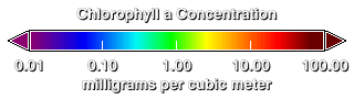
The legend for ocean color measurements.
Available formats:
320 x 90
PNG
13 KB
|
|
|
Back to Top
|


