Skip all navigation and jump to content Jump to site navigation Jump to section navigation.
NASA Logo - Goddard Space Flight Center + Visit NASA.gov
HOME PROJECTS RESOURCES SEARCH MAP

+ Advanced Search
Home
Home
View Most Recently Released Imagery
View Gallery of Imagery: A topical collection of SVS Imagery
Search Imagery by the keywords assigned to it
Search Imagery by the instruments that supplied data for a visualization product
Search Imagery by the series of visualizations that have been produced
Search Imagery by the scientist providing the data used in a visualization product
Search Imagery by the animator that created the product
Search Imagery by the identification number assigned to the visualization product
See other search options
Learn about the SVS Image Server
  + About the Server
  + Animation List
  + How to Use the Server


  + RSS Feeds
blank image
Previous Animation
Next Animation
Aqua/AIRS Water Vapor near southern California #2

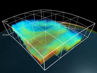
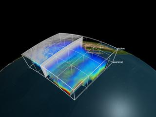
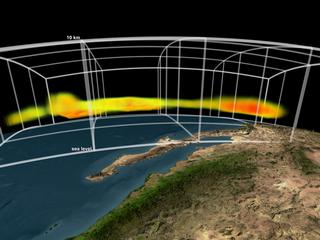
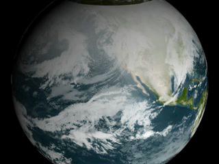
This visualization shows 3D volumetric water vapor data from the Aqua/Atmospheric Infrared Sounder (AIRS) instrument. As the camera moved down and around the data set, the low data values are faded out revealing only the highest concentrations of water vapor data.

This version (#2) ends with a slightly lower threshold than the original version - showing more of the highest water vapor concentrations.

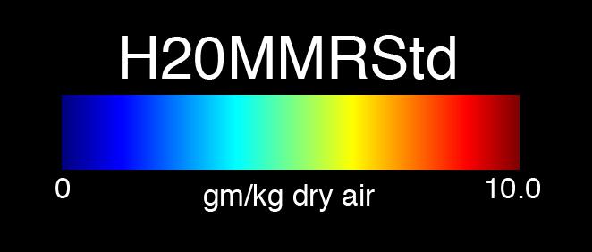
The color and opacity at each 3D voxel are driven by the water vapor data. The data set was obtained by Aqua on January 1, 2003. Only data from the sea level to about 10km are shown.

This visualization was created to support a JPL press release about how assimilated AIRS data is improving global atmospheric simulation model forecasts by about 6 hours (from about 5 days to about 5 days and 6 hours).


Fly over of Aqua/AIRS volumetric water vapor data    Fly over of Aqua/AIRS volumetric water vapor data
Duration: 27.0 seconds
Available formats:
  720x486 (30 fps) Frames
  640x480 (30 fps) MPEG-1   14 MB
  720x480 (29.97 fps) MPEG-2   23 MB
  320x240 (30 fps) MPEG-1   3 MB
  320x240     JPEG         11 KB
  1280x720 (29.97 fps) Frames
How to play our movies


 Aqua-AIRS water vapor data (tight view, lower values faded out)    Aqua-AIRS water vapor data (tight view, lower values faded out)

Available formats:
  3200 x 2400     TIFF 4 MB
  160 x 80           PNG 31 KB
  320 x 240         JPEG 11 KB
  80 x 40             PNG 15 KB


 Aqua-AIRS water vapor data (wide view)    Aqua-AIRS water vapor data (wide view)

Available formats:
  3200 x 2400     TIFF 9 MB
  320 x 240         JPEG 7 KB


 Aqua-AIRS water vapor data (highest water vapor concentrations)    Aqua-AIRS water vapor data (highest water vapor concentrations)

Available formats:
  3200 x 2400     TIFF 11 MB
  320 x 240         JPEG 14 KB


 Aqua-AIRS water vapor: 0=blue, 10=red
   Aqua-AIRS water vapor: 0=blue, 10=red

Available formats:
  662 x 282         TIFF 66 KB
  662 x 282         JPEG 14 KB

Animation Number:3129
Animator:Greg Shirah (SVS) (Lead)
Completed:2005-02-09
Scientists:Sharon Okonek (NASA/JPL CalTech)
 Bjorn H. Lambrigtsen (NASA/JPL CalTech)
 Tom Pagano (NASA/JPL CalTech)
 Edward Olsen (NASA/JPL CalTech)
Instrument:Aqua/AIRS
Data set:Aqua/AIRS Level 2 Water Vapor (H2OMMRStd)
Data Collected:2003/01/01
Goddard TV Tape:G2008-042HD -- HD Fires, Ozone, and Air Quality RT
Keywords:
SVS >> HDTV
SVS >> Volume
SVS >> Water Vapor
 
 
Please give credit for this item to
NASA/Goddard Space Flight Center
Scientific Visualization Studio


Back to Top

USA.gov logo - the U.S. Government's official Web portal. + Privacy Policy and Important Notices
+ Reproduction Guidelines
NASA NASA Official:
SVS Contact:
Curator: