|
|
 |
Landsat Witnesses the Destruction of Mesopotamian Ecosystem
|
|
In one of the greatest ecological disasters of our time, the ancient marshlands of Mesopotamia are systematically being converted to dry salt flats as a result of human mismanagement of the region's water resources. Landsat satellite imagery reveals that in the last 10 years, wetlands that once covered as much as 20,000 square km in parts of Iraq and Iran have been reduced to a small fraction of their original size. The authors of a new report released by the United Nations Environment Programme (UNEP) at the 11th Stockholm Water Symposium on August 13, 2001, warn that the marshlands could completely disappear within the next 3-5 years unless dramatic steps are taken immediately to reverse the damage being done. The UNEP Executive Director described the wetlands' condition as 'a major environmental catastrophe that will be remembered as one of humanity's worst engineered disasters.' He noted that 'the tragic loss of this rare wetland has occurred in approximately the same period since world leaders pledged to safeguard the environment at the United Nations Conference on Environment and Development (the Earth Summit) held in Rio de Janeiro in 1992.' Regarded by historians as one of the cradles of civilization, the Mesopotamian Fertile Crescent has supported Marsh Arab society for millennia. But through the damming and siphoning off of waters from the Tigris and Euphrates Rivers, the countries of Iran, Iraq, Turkey, and Syria have decimated the ecosystem and, with it, a culture rooted in the dawn of human history (dating back to ancient Sumeria about 5,000 years ago).
|
|

|
|
The ancient marshlands of Mesopotamia as seen by Landsat images from 1973 to 2000.
Duration: 13.0 seconds
Available formats:
320x240 (30 fps)
MPEG-1
1 MB
320x240
JPEG
9 KB
How to play our movies
|
|
|
|
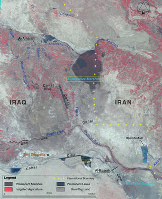
Landsat image in 1973 with the rivers, marshes, and countries labeled
Available formats:
870 x 1024
TIFF
1 MB
320 x 376
JPEG
32 KB
|
|
|
|
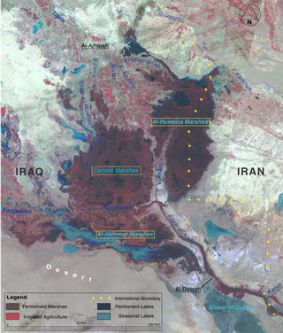
Landsat image in 2000 with the damns, dikes, rivers, marshes, and countries labeled
Available formats:
832 x 1024
TIFF
1 MB
320 x 393
JPEG
30 KB
|
|
|
|
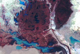
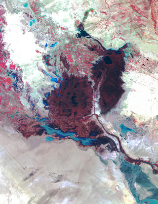
Mesopotamia 1973. Zoom into Euphrates, Tigris, and Shatt-al-Arab Rivers
Available formats:
1440 x 972
TIFF
2 MB
160 x 80
PNG
26 KB
320 x 216
JPEG
19 KB
80 x 40
PNG
7 KB
|
|
|
|
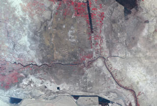
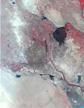
Mesopotamia in March 2000. Zoom into Euphrates, Tigris, and Shatt-al-Arab Rivers
Available formats:
1440 x 972
TIFF
2 MB
160 x 80
PNG
25 KB
320 x 216
JPEG
15 KB
80 x 40
PNG
6 KB
|
|
|
|
Mesopotamia 1973
Available formats:
5637 x 7264
TIFF
74 MB
320 x 412
JPEG
39 KB
|
|
|
|
Mesopotamia 2000
Available formats:
5637 x 7264
TIFF
60 MB
320 x 412
JPEG
28 KB
|
|
|
Back to Top
|
|
|
|

