Skip all navigation and jump to content Jump to site navigation Jump to section navigation.
NASA Logo - Goddard Space Flight Center + Visit NASA.gov
HOME PROJECTS RESOURCES SEARCH MAP

+ Advanced Search
Home
Home
View Most Recently Released Imagery
View Gallery of Imagery: A topical collection of SVS Imagery
Search Imagery by the keywords assigned to it
Search Imagery by the instruments that supplied data for a visualization product
Search Imagery by the series of visualizations that have been produced
Search Imagery by the scientist providing the data used in a visualization product
Search Imagery by the animator that created the product
Search Imagery by the identification number assigned to the visualization product
See other search options
Learn about the SVS Image Server
  + About the Server
  + Animation List
  + How to Use the Server


  + RSS Feeds
blank image
Previous Animation
Next Animation
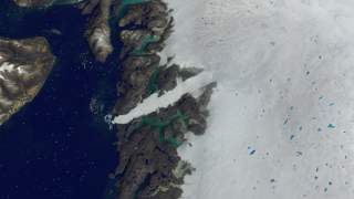
Zoom from Jakobshavn Glacier with AMSR-E Daily Sea Ice and MODIS Daily Snow Cover

Beginning from a view of Greenland's Jakobshavn glacier, this animation shows motion of sea ice and snow cover over the Arctic from 10/1/2002 through 6/23/2003 as the camera pulls out to frame the full globe. The false color of the sea ice is derived from the AMSR-E 6.25 km brightness temperature. The sea ice extent is defined by AMSR-E 12.5 km sea ice concentration, identifying all regions having a sea ice concentration of greater than 15%. Because AMSR-E is a passive microwave sensor that functions independently from atmospheric effects, this sensor is able to observe the entire polar region every day, even through clouds and snowfalls.

This animation moves from a view of the Jakobshavn glacier in Greenland to a full global view, showing seasonal changes in Arctic sea ice and global snow cover. (slower version)    This animation moves from a view of the Jakobshavn glacier in Greenland to a full global view, showing seasonal changes in Arctic sea ice and global snow cover. (slower version)
Duration: 32.0 seconds
Available formats:
  320x180     PNG           84 KB
  160x80       PNG           20 KB
  80x40         PNG           5 KB
  1280x720 (30 fps) MPEG-4   32 MB
  512x288 (30 fps) MPEG-4   15 MB
  512x288 (30 fps) MPEG-1   10 MB
  720x480 (30 fps) MPEG-2   19 MB
  1280x720 (29.97 fps) Frames (Slow)
How to play our movies


This still image shows the Arctic sea ice along with global snow cover.    This still image shows the Arctic sea ice along with global snow cover.

Available formats:
  2560 x 1920     TIFF 5 MB
  320 x 240         PNG 47 KB

Animation Number:3373
Animators:Cindy Starr (SVS) (Lead)
 Ryan Boller (SVS)
 Stuart A. Snodgrass (SVS)
Completed:2006-09-06
Scientists:Waleed Abdalati (NASA/HQ)
 Richard Alley (Pennsylvania State University)
Instruments:Aqua/AMSR-E
 Terra/MODIS
Data sets:Blue Marble landcover
 MODIS/Terra Snow Cover Daily L3 Global 0.05Deg CMG (MOD10C1)
 Daily L3 6.25 km 89 GHz Brightness Temperature (Tb)
Data Collected:AMSR-E Level 3 6.25 km Sea Ice Brightness Temperature (10/01/2002 - 06/23/2003), AMSR-E Level 3 12.5 km Sea Ice Concentration (10/01/2002 - 06/23/2003),MODIS Daily Snow Cover (10/01/2002 - 06/23/2003), MODIS imagery of Greenland (06/25/2003)
Series:NASM2006
Keywords:
DLESE >> Cryology
SVS >> HDTV
SVS >> Sea Ice
SVS >> Snow
SVS >> Snow Cover
SVS >> Snow and Ice
GCMD >> EARTH SCIENCE >> Cryosphere
GCMD >> EARTH SCIENCE >> Cryosphere >> Sea Ice
GCMD >> EARTH SCIENCE >> Cryosphere >> Snow/Ice
GCMD >> EARTH SCIENCE >> Hydrosphere >> Snow/Ice
GCMD >> EARTH SCIENCE >> Oceans >> Sea Ice
GCMD >> EARTH SCIENCE >> Atmosphere >> Precipitation >> Snow
GCMD >> EARTH SCIENCE >> Cryosphere >> Sea Ice >> Ice Growth/Melt
GCMD >> EARTH SCIENCE >> Cryosphere >> Sea Ice >> Sea Ice Concentration
GCMD >> EARTH SCIENCE >> Cryosphere >> Sea Ice >> Sea Ice Motion
GCMD >> EARTH SCIENCE >> Cryosphere >> Snow/Ice >> Ice Growth/Melt
GCMD >> EARTH SCIENCE >> Cryosphere >> Snow/Ice >> Ice Motion
GCMD >> EARTH SCIENCE >> Cryosphere >> Snow/Ice >> Snow Cover
GCMD >> EARTH SCIENCE >> Hydrosphere >> Snow/Ice >> Ice Motion
GCMD >> EARTH SCIENCE >> Hydrosphere >> Snow/Ice >> Snow Cover
GCMD >> EARTH SCIENCE >> Oceans >> Sea Ice >> Ice Growth/Melt
GCMD >> Location >> Arctic
 
 
Please give credit for this item to
NASA/Goddard Space Flight Center Scientific Visualization Studio
The Blue Marble data is courtesy of Reto Stockli (NASA/GSFC).
Jeff Schmaltz (NASA/GSFC)


Back to Top

USA.gov logo - the U.S. Government's official Web portal. + Privacy Policy and Important Notices
+ Reproduction Guidelines
NASA NASA Official:
SVS Contact:
Curator: