Skip all navigation and jump to content Jump to site navigation Jump to section navigation.
NASA Logo - Goddard Space Flight Center + Visit NASA.gov
HOME PROJECTS RESOURCES SEARCH MAP

+ Advanced Search
Home
Home
View Most Recently Released Imagery
View Gallery of Imagery: A topical collection of SVS Imagery
Search Imagery by the keywords assigned to it
Search Imagery by the instruments that supplied data for a visualization product
Search Imagery by the series of visualizations that have been produced
Search Imagery by the scientist providing the data used in a visualization product
Search Imagery by the animator that created the product
Search Imagery by the identification number assigned to the visualization product
See other search options
Learn about the SVS Image Server
  + About the Server
  + Animation List
  + How to Use the Server


  + RSS Feeds
  + Podcasts


  + Opportunities
blank image
Previous Animation
Next Animation
Lake Chad 2001

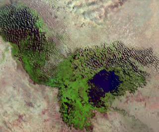
Sweep of Lake Chad, February 2001.

Located on the edge of the Sahara and bordering four countries--Chad, Cameroon, Nigeria, and Niger--the immense area of this land locked lake has nearly disappeared in recent years. Persistent drought has caused the lake to drop from its former sixth place position in the list of world's largest lakes; it is now one tenth its former size.

The basin of the lake is not naturally deep, so the surface area of the lake tended to spread out, keeping the total depth to little more 23 feet (7 meters). In recent years, rainfall patterns have begun to change, and tributaries to Lake Chad have not been refilling the basin as rapidly as they used to. The lush, productive flora and fauna fed by the wetlands of the shallow lake have suffered as a result.

This has led to significant changes for various communities of people that live in the vicinity of the Lake. While for some the now exposed lake bed has enabled new land to be cultivated, much of the available fresh water that might have been used for irrigation is no longer dependable. As rainfall rates appear to be declining year after year, people living nearby develop even greater dependence on the lake, draining it even faster.


Close-up view of Lake Chad in 2001    Close-up view of Lake Chad in 2001
Duration: 13.0 seconds
Available formats:
  320x240 (30 fps) MPEG-1   1 MB
  160x80       PNG           27 KB
  80x40         PNG           7 KB
  320x266     JPEG         19 KB
  320x240 (30 fps) X-FLV       537 KB
How to play our movies


Lake Chad in 2001    Lake Chad in 2001

Available formats:
  2880 x 1944     TIFF 7 MB
  320 x 216         JPEG     15 KB
  160 x 80           PNG       26 KB

Animation Number:2066
Completed:2001-02-22
Animators:Joycelyn Thomson (NASA/GSFC) (Lead)
 Stuart A. Snodgrass (GST)
Scientist:Michael Coe (University of Wisconsin-Madison)
Platform/Sensor/Data Set:Landsat-7/ETM+ (February 2001)
Series:Lake Chad Evaporation
Video:SVS2001-0005 *
Keywords:
DLESE >> Agricultural science
DLESE >> Environmental science
DLESE >> Hydrology
DLESE >> Natural hazards
GCMD >> EARTH SCIENCE >> Atmosphere >> Atmospheric Water Vapor >> Evaporation
GCMD >> Location >> Lake Chad
GCMD >> Location >> Africa
More Information on this topic available at:
stories/earthday2001/index.html
This work has been visible on
Discover Magazine Vol. 22 No. 6 June 2001 pp.10
 
 
Please give credit for this item to
NASA/Goddard Space Flight Center
Scientific Visualization Studio


*Please note: the SVS does not fulfill requests for copies of the tapes in our library. On some of our animation pages, there is a direct link to a video distribution service from which tapes, handled by the Public Affairs Office (PAO)/Goddard TV, including some of our animations may be ordered. General information on this service can be found here.


Back to Top

USA.gov logo - the U.S. Government's official Web portal. + Privacy Policy and Important Notices
+ Reproduction Guidelines
NASA NASA Official:
SVS Contact:
Curator: