ICESat First Light Release: Antarctica in Three Dimensions
|
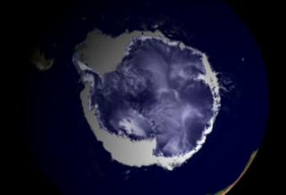
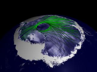
ICESat's orbit was designed to maximize coverage over the great polar ice sheets, where ground tracks overlap to create an intricate grid of data points. The accumulation of these data points in the Southern Hemisphere results in a new three-dimensional elevation model of Antarctica. ICESat repeats its orbital pattern every eight days, allowing the GLAS instrument to measure changes over time in the same location. In order to measure ice sheet mass balance, the satellite's advanced technology is providing data on the critically important third dimension, elevation.
|
|
|
|
Animation showing ICESat tracks criss-crossing over Antarctica
Duration: 30.0 seconds
Available formats:
720x486 (29.97 fps)
Frames
352x240 (30 fps)
MPEG-1
4 MB
320x218
JPEG
6 KB
720x480 (29.97 fps)
DV
106 MB
How to play our movies
|
|
|
|
ICESat tracks criss-crossing over Antarctica
Available formats:
2560 x 1920
TIFF
4 MB
160 x 80
PNG
21 KB
320 x 240
JPEG
10 KB
80 x 40
PNG
6 KB
|
|

|
|
None
Available formats:
720 x 528
JPEG
90 KB
320 x 234
PNG
319 KB
|
| Animation Number: | 2745 |
| Animators: | Greg Shirah (Lead) |
| | Alex Kekesi |
| Studio: | NASA |
| Completed: | 2003-05-15 |
| Scientists: | Chris Shuman (NASA/GSFC) |
| | Jay Zwally (NASA/GSFC) |
| Instruments: | ICESat/GLAS
|
| | RADARSAT-1/SAR |
| | Terra/MODIS |
| Data set: | Blue Marble |
| Data Collected: | Simulated Data |
| Series: | ICESat |
| Video: | SVS2003-0015 * |
Keywords:
SVS
>> Ice
DLESE
>> Technology
GCMD
>> Location
>> Antarctica
|
|
Please give credit for this item to
NASA/Goddard Space Flight Center
Scientific Visualization Studio, Canadian Space Agency, RADARSAT International Inc. |
*Please note: the SVS does not fulfill requests for copies of the tapes in our library. On some of our animation pages, there is a direct link to a video distribution service from which tapes, handled by the Public Affairs Office (PAO)/Goddard TV, including some of our animations may be ordered. General information on this service can be found here. |
|
Back to Top
|

