| Home >> | Advanced Search >> |
 |
|
Astronaut Photography of Earth - Display Record
ISS017-E-8285

Low-resolution Browse Image
(Most browse images are not color adjusted.)Images
Conditions for Use of Images >>Image Transformation Tutorial >> Saving, Color Adjusting, and Printing Images >>
Images to View on Your Computer Now
| File Name | File Size (bytes) | Width | Height | Annotated | Cropped | Purpose | Comments | |
|---|---|---|---|---|---|---|---|---|
| View | ISS017-E-8285.JPG | 64125 | 639 | 437 | No | No | ||
| View | ISS017-E-8285.JPG | 277497 | 540 | 371 | Yes | Yes | NASA's Earth Observatory web site |
Large Images to Request for Downloading
| File Name | File Size (bytes) | Width | Height | Annotated | Cropped | Purpose | Comments | |
|---|---|---|---|---|---|---|---|---|
| Request | ISS017-E-8285.JPG | 956430 | 1000 | 687 | No | Yes | NASA's Earth Observatory web site | |
| Request | ISS017-E-8285.JPG | 1540220 | 3072 | 2098 | No | No |
Download a Keyhole Markup Language (KML) file for use in Google Earth.
Electronic Image Data
Camera Files >> No sound file available.Identification
Mission: ISS017 Roll: E Frame: 8285 Mission ID on the Film or image: ISS017Country or Geographic Name: EGYPT
Features: PYRAMIDS, DAHSHUR, NILE R. V.
Center Point Latitude: 29.8 Center Point Longitude: 31.2 (Negative numbers indicate south for latitude and west for longitude)
Stereo: (Yes indicates there is an adjacent picture of the same area)
ONC Map ID: JNC Map ID:
Camera
Camera Tilt: 40Camera Focal Length: 800mm
Camera: N2: Nikon D2Xs
Film: 4288E : 4288 x 2848 pixel CMOS sensor, RGBG imager color filter.
Quality
Film Exposure:Percentage of Cloud Cover: 10 (0-10)
Nadir
Date: 20080530 (YYYYMMDD)GMT Time: 143208 (HHMMSS)Nadir Point Latitude: 32.0, Longitude: 30.0 (Negative numbers indicate south for latitude and west for longitude)
Nadir to Photo Center Direction: Southeast
Sun Azimuth: 279 (Clockwise angle in degrees from north to the sun measured at the nadir point)
Spacecraft Altitude: 182 nautical miles (337 km)
Sun Elevation Angle: 29 (Angle in degrees between the horizon and the sun, measured at the nadir point)
Orbit Number: 2575
Captions
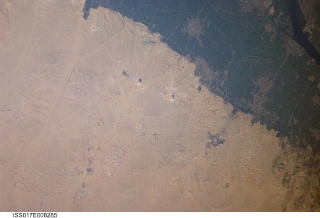
Pyramids of Dashur, EgyptWhile the pyramids of Giza are perhaps the most famous, there are several other ancient Egyptian royal necropolis (“city of the dead”) sites situated along the Nile River and its delta. One of these sites is near the village of Dashur, illustrated in this astronaut photograph. The gray-brown built area of Dashur is surrounded by green agricultural land of the Nile Delta, which forms a distinct boundary with the tan desert to the west. It is in the desert that the monuments of the ancient rulers of Egypt are found.
Several monuments are visible in this image, including the large Red and Bent Pyramids built by Snofru, first king of the Fourth Dynasty, which lasted from 2575–2465 BC. Other visible monuments include the pyramid complexes of Amenemhat III and Sesostris III, both kings of the Twelfth Dynasty (1991–1783 BC). Both of these complexes are poorly preserved, due to both the unstable ground conditions and the dismantling of the limestone blocks forming the outer pyramid casings during later historical periods.
The Bent Pyramid (image upper right) is so called because the slope of the outer face was lessened halfway through construction, leading to a distinctive “bent” profile. Scholars have offered different explanations for why this was done: perhaps to decrease the mass of the pyramid to prevent its collapse or to reduce the work necessary to complete it. The Red Pyramid to the north (image center) was built after the Bent Pyramid, and is named for the coloration of the building stone at the structure’s core. Compare the shadows of the Red and Bent pyramids in the image to see the different profiles of the structures (easier to see in the large image.) An irregular, dark feature to the southeast of the Bent Pyramid is not a shadow cast by a monument; it is an irrigation area extending into the desert.
Download Packaged File.
This option downloads the following items, packaged into a single file, if they are available:
- Browse image
- Cataloged information with captions
- Camera file
- Sound file
Server: 2 |
This service is provided by the International Space Station program. |
Recommended Citation: |
||

