Skip all navigation and jump to content Jump to site navigation Jump to section navigation.
NASA Logo - Goddard Space Flight Center + Visit NASA.gov
HOME PROJECTS RESOURCES SEARCH MAP

+ Advanced Search
Home
Home
View Most Recently Released Imagery
View Gallery of Imagery: A topical collection of SVS Imagery
Search Imagery by the keywords assigned to it
Search Imagery by the instruments that supplied data for a visualization product
Search Imagery by the series of visualizations that have been produced
Search Imagery by the scientist providing the data used in a visualization product
Search Imagery by the animator that created the product
Search Imagery by the identification number assigned to the visualization product
See other search options
Learn about the SVS Image Server
  + About the Server
  + Animation List
  + How to Use the Server


  + RSS Feeds
blank image
Previous Animation
Next Animation
AMSR-E Antarctic Sea Ice

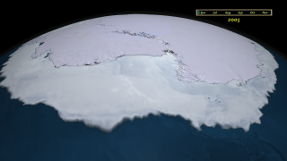
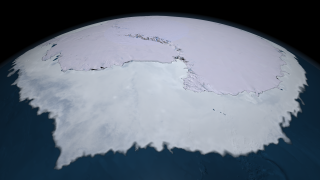
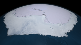
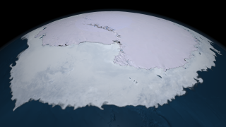
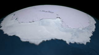
Antarctica is a land mass surrounded by an ocean which allows the sea ice here to move more freely than it does in the Northern Hemisphere. Because there are no surrounding continents to limit its movement, the sea ice is free to float northward into warmer waters where it eventually melts. As a result, almost all of the sea ice that forms during the Antarctic winter melts during the summer. During the winter, up to 18 million square kilometers (6.9 million square miles) of ocean is covered by sea ice, but by the end of summer, only about 3 million square kilometers (1.1 million square miles) of sea ice remain. Both Arctic and Antarctic sea ice extent are characterized by fairly large variations from year to year. The monthly average extent can vary by as much as 1 million square kilometers (386,102 square miles) from the year-to-year monthly average. The area covered by Antarctic sea ice has shown a small increasing trend.

The AMSR-E instrument on the Aqua satellite acquires high resolution measurements of the 89 GHz brightness temperature near the poles. Because this is a passive microwave sensor which is not so sensitive to atmospheric effects, this sensor is able to observe the entire polar region every day, even through clouds and snowfall. The false color in this animation of sea ice surrounding the South Pole is derived from the daily AMSR-E 6.25 km 89 GHz brightness temperature while the sea ice extent is derived from the daily AMSR-E 12.5 km sea ice concentration. The sea ice extent shown is generated using a three day moving average where the daily sea ice concentration is at least 15%. This animation progresses at a rate of four frames per day from June 4, 2005 through November 18, 2005.


Animation of sea ice motion around Antarctica during 2005 with a date overlay.    Animation of sea ice motion around Antarctica during 2005 with a date overlay.
Duration: 22.0 seconds
Available formats:
  1280x720 (30 fps) MPEG-4   17 MB
  1280x720 (30 fps) Frames (SeaIce withDate)
  1280x720 (30 fps) Frames (Date overlay)
  1280x720 (30 fps) MPEG-2   12 MB
  320x180     PNG           205 KB
  160x80       PNG           56 KB
  80x40         PNG           15 KB
  640x360 (30 fps) MPEG-4   4 MB
  640x360 (30 fps) MPEG-1   4 MB
  640x360 (30 fps) MPEG-2   4 MB
How to play our movies


Animation of sea ice motion around Antarctica during 2005.    Animation of sea ice motion around Antarctica during 2005.
Duration: 22.0 seconds
Available formats:
  1280x720 (30 fps) MPEG-2   46 MB
  1280x720 (30 fps) Frames (SeaIce)
  640x360 (30 fps) MPEG-4   4 MB
  1280x720 (30 fps) MPEG-4   17 MB
  320x180     PNG           206 KB
How to play our movies


Sea ice surrounding Antarctica on July 14, 2005.    Sea ice surrounding Antarctica on July 14, 2005.

Available formats:
  2560 x 1440     TIFF 2 MB
  320 x 180         PNG 222 KB


Sea ice surrounding Antarctica on August 14, 2005.    Sea ice surrounding Antarctica on August 14, 2005.

Available formats:
  2560 x 1440     TIFF 2 MB
  320 x 180         PNG 221 KB


Sea ice surrounding Antarctica on September 21, 2005.    Sea ice surrounding Antarctica on September 21, 2005.

Available formats:
  2560 x 1440     TIFF 2 MB
  320 x 180         PNG 222 KB

Animation Number:3497
Animators:Cindy Starr (SVS) (Lead)
 Lori Perkins (SVS)
Completed:2008-03-13
Producer:Sarah DeWitt (NASA/GSFC)
Scientist:Bob Bindschadler (NASA/GSFC)
Instrument:Aqua/AMSR-E
Data sets:Daily L3 6.25 km 89 GHz Brightness Temperature (Tb)
 AMSR-E Level 3 12.5 km Sea Ice Concentration
 LandSat Image Mosaic of Antarctica
Data Collected:2005/06/04 through 2005/11/18
Keywords:
DLESE >> Cryology
SVS >> HDTV
DLESE >> Physical oceanography
GCMD >> EARTH SCIENCE >> Cryosphere
GCMD >> EARTH SCIENCE >> Cryosphere >> Sea Ice
GCMD >> EARTH SCIENCE >> Cryosphere >> Snow/Ice
GCMD >> EARTH SCIENCE >> Hydrosphere >> Snow/Ice
GCMD >> EARTH SCIENCE >> Oceans >> Sea Ice
GCMD >> EARTH SCIENCE >> Cryosphere >> Sea Ice >> Ice Extent
GCMD >> EARTH SCIENCE >> Cryosphere >> Sea Ice >> Ice Floes
GCMD >> EARTH SCIENCE >> Cryosphere >> Sea Ice >> Ice Growth/Melt
GCMD >> EARTH SCIENCE >> Cryosphere >> Sea Ice >> Ice Types
GCMD >> EARTH SCIENCE >> Cryosphere >> Sea Ice >> Pack Ice
GCMD >> EARTH SCIENCE >> Cryosphere >> Sea Ice >> Sea Ice Concentration
GCMD >> EARTH SCIENCE >> Cryosphere >> Sea Ice >> Sea Ice Motion
GCMD >> EARTH SCIENCE >> Cryosphere >> Snow/Ice >> Freeze/Thaw
GCMD >> EARTH SCIENCE >> Cryosphere >> Snow/Ice >> Ice Extent
GCMD >> EARTH SCIENCE >> Cryosphere >> Snow/Ice >> Ice Growth/Melt
GCMD >> EARTH SCIENCE >> Cryosphere >> Snow/Ice >> Ice Motion
GCMD >> EARTH SCIENCE >> Cryosphere >> Snow/Ice >> Snow/Ice Temperature
GCMD >> EARTH SCIENCE >> Hydrosphere >> Snow/Ice >> Ice Extent
GCMD >> EARTH SCIENCE >> Hydrosphere >> Snow/Ice >> Ice Motion
GCMD >> EARTH SCIENCE >> Oceans >> Sea Ice >> Ice Extent
GCMD >> EARTH SCIENCE >> Oceans >> Sea Ice >> Ice Floes
GCMD >> EARTH SCIENCE >> Oceans >> Sea Ice >> Ice Growth/Melt
GCMD >> EARTH SCIENCE >> Oceans >> Sea Ice >> Pack Ice
 
 
Please give credit for this item to
NASA/Goddard Space Flight Center Scientific Visualization Studio
The Blue Marble data is courtesy of Reto Stockli (NASA/GSFC).


Back to Top

USA.gov logo - the U.S. Government's official Web portal. + Privacy Policy and Important Notices
+ Reproduction Guidelines
NASA NASA Official:
Content Contact:
Curator: