|
|
 |
Sample LIMA Data versus MOA Data of McMurdo Station
|
The Landsat Image Mosaic of Antarctica (LIMA) is a data product funded by the National Science Foundation (NSF) and jointly produced by the U.S. Geological Survey (USGS), the British Antarctic Survey (BAS), and the National Aeronautics and Space Administration (NASA). The images shown here are compared to what is currently the best mosaic of Antarctica called the MODIS Mosaic of Antarctica (MOA). MOA is a composite of 260 swaths comprised of both Terra and Aqua MODIS images acquired between November 20, 2003 and February 29, 2004. MOA's data resolution is approximately 150 meters per pixel. From large continental views of Antarctica, MOA is more than adequate. However, as we get closer in to the surface, the resolution of the MOA data begins to show, thus highlighting the value of the LIMA product once it is complete. The LIMA data shown here uses the pan-chromatic band which translates to a resolution of 15 meters per pixel (opposed to MOA's 150 meters per pixel resolution). The 13 swaths used to generate this sample mosaic where acquired between December 25, 1999 and December 31, 2001. The elevation shown is actual (1x). Comparing this sample LIMA data set alongside MOA data over the same region shows the value of having a higher resolution view of Antarctica.
|
|
|
|
This brief animation does a mosaic dissolve between the lower resolution MOA data of McMurdo Station to the high resolution LIMA data of the same region.
Duration: 3.0 seconds
Available formats:
512x288 (60 fps)
MPEG-1
1 MB
1280x720 (59.94 fps)
Frames
320x180
PNG
248 KB
1280x720 (60 fps)
MPEG-2
1 MB
1280x720 (59.94 fps)
MPEG-4
1 MB
How to play our movies
|
|
|
|
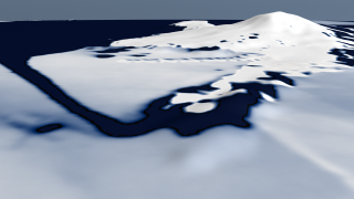
Lower resolution MOA data (150 meters per pixel) of the same area immediately surrounding McMurdo Station. At this resolution McMurdo cannot be seen.
Available formats:
1280 x 720
TIFF
1 MB
320 x 180
PNG
231 KB
|
|
|
|
|
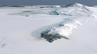
High resolution LIMA data (15 meters per pixel) of the area immediately surrounding McMurdo Station. If you look really close in the foreground, McMurdo Station can be seen as a few white dots on the open rocky outcrop of Ross Island's peninsula. The straight lines in the lower left corner of the picture are runways.
Available formats:
1280 x 720
TIFF
1 MB
320 x 180
PNG
248 KB
160 x 80
PNG
61 KB
80 x 40
PNG
15 KB
|
|
|
Back to Top
|
|
|
|

