| Home >> | Advanced Search >> |
 |
|
Astronaut Photography of Earth - Display Record
ISS005-E-11203

Low-resolution Browse Image
(Most browse images are not color adjusted.)Images
Conditions for Use of Images >>Image Transformation Tutorial >> Saving, Color Adjusting, and Printing Images >>
Images to View on Your Computer Now
| File Name | File Size (bytes) | Width | Height | Annotated | Cropped | Purpose | Comments | |
|---|---|---|---|---|---|---|---|---|
| View | ISS005-E-11203.JPG | 73319 | 639 | 435 | No | No | ||
| View | ISS005-E-11203.JPG | 245499 | 540 | 375 | Yes | Yes | NASA's Earth Observatory web site |
Large Images to Request for Downloading
| File Name | File Size (bytes) | Width | Height | Annotated | Cropped | Purpose | Comments | |
|---|---|---|---|---|---|---|---|---|
| Request | ISS005-E-11203.JPG | 660734 | 1000 | 694 | No | Yes | NASA's Earth Observatory web site | |
| Request | ISS005-E-11203.JPG | 1434764 | 3032 | 2064 | No | No |
Download a Keyhole Markup Language (KML) file for use in Google Earth.
Electronic Image Data
Camera Files >> No sound file available.Identification
Mission: ISS005 Roll: E Frame: 11203 Mission ID on the Film or image: ISS005Country or Geographic Name: RUSSIAN FEDERATION
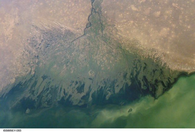
Features: VOLGA DELTA
Center Point Latitude: 46.0 Center Point Longitude: 48.5 (Negative numbers indicate south for latitude and west for longitude)
Stereo: (Yes indicates there is an adjacent picture of the same area)
ONC Map ID: JNC Map ID:
Camera
Camera Tilt: 47Camera Focal Length: 48mm
Camera: E4: Kodak DCS760C Electronic Still Camera
Film: 3060E : 3060 x 2036 pixel CCD, RGBG array.
Quality
Film Exposure:Percentage of Cloud Cover: 10 (0-10)
Nadir
Date: 20020825 (YYYYMMDD)GMT Time: 062351 (HHMMSS)Nadir Point Latitude: 46.2, Longitude: 52.2 (Negative numbers indicate south for latitude and west for longitude)
Nadir to Photo Center Direction: West
Sun Azimuth: 132 (Clockwise angle in degrees from north to the sun measured at the nadir point)
Spacecraft Altitude: 211 nautical miles (391 km)
Sun Elevation Angle: 45 (Angle in degrees between the horizon and the sun, measured at the nadir point)
Orbit Number: 1484
Captions
ISS005-E-11203 (25 Aug. 2002) --- The Volga Delta, Russia is featured in this image photographed by an Expedition Five crewmember on the International Space Station. The Volga River drains much of western Russia's industrial region and travels southward to empty into the Caspian Sea. According to scientists, over thousands of years, the river has built out a tremendous delta that forms the northwestern shoreline of the Caspian Sea. The Volga Delta is many things: the delta channels provide transportation access between the heartland of Russia and the oil-rich Caspian Sea. The Volga's extensive distributaries harbor habitat and rich fishing grounds for Russia's famous beluga sturgeon -- better known as the source of beluga caviar. The delta's wetlands, parts of which are designated as the Astrakhanskiy Biosphere Reserve, are important stopping points and breeding grounds for migrating water birds.Download Packaged File.
This option downloads the following items, packaged into a single file, if they are available:
- Browse image
- Cataloged information with captions
- Camera file
- Sound file
Server: 2 |
This service is provided by the International Space Station program. |
Recommended Citation: |
||

