| Home >> | Advanced Search >> |
 |
|
Astronaut Photography of Earth - Display Record
ISS013-E-81687

Low-resolution Browse Image
(Most browse images are not color adjusted.)Images
Conditions for Use of Images >>Image Transformation Tutorial >> Saving, Color Adjusting, and Printing Images >>
Images to View on Your Computer Now
| File Name | File Size (bytes) | Width | Height | Annotated | Cropped | Purpose | Comments | |
|---|---|---|---|---|---|---|---|---|
| View | ISS013-E-81687.JPG | 68463 | 639 | 435 | No | No | ||
| View | ISS013-E-81687.JPG | 423956 | 540 | 816 | Yes | Yes | NASA's Earth Observatory web site |
Large Images to Request for Downloading
| File Name | File Size (bytes) | Width | Height | Annotated | Cropped | Purpose | Comments | |
|---|---|---|---|---|---|---|---|---|
| Request | ISS013-E-81687.JPG | 1104871 | 3032 | 2064 | No | No | ||
| Request | ISS013-E-81687.JPG | 1113392 | 1000 | 1511 | No | Yes | NASA's Earth Observatory web site |
Download a Keyhole Markup Language (KML) file for use in Google Earth.
Electronic Image Data
Camera Files >> No sound file available.Identification
Mission: ISS013 Roll: E Frame: 81687 Mission ID on the Film or image: ISS013Country or Geographic Name: USA-CALIFORNIA
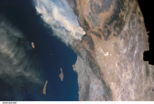
Features: THICK SMOKE, LOS ANGELES
Center Point Latitude: 34.5 Center Point Longitude: -118.0 (Negative numbers indicate south for latitude and west for longitude)
Stereo: (Yes indicates there is an adjacent picture of the same area)
ONC Map ID: JNC Map ID:
Camera
Camera Tilt: 45Camera Focal Length: 28mm
Camera: E4: Kodak DCS760C Electronic Still Camera
Film: 3060E : 3060 x 2036 pixel CCD, RGBG array.
Quality
Film Exposure:Percentage of Cloud Cover: 10 (0-10)
Nadir
Date: 20060917 (YYYYMMDD)GMT Time: 225236 (HHMMSS)Nadir Point Latitude: 31.7, Longitude: -119.4 (Negative numbers indicate south for latitude and west for longitude)
Nadir to Photo Center Direction: Northeast
Sun Azimuth: 244 (Clockwise angle in degrees from north to the sun measured at the nadir point)
Spacecraft Altitude: 186 nautical miles (344 km)
Sun Elevation Angle: 38 (Angle in degrees between the horizon and the sun, measured at the nadir point)
Orbit Number: 779
Captions
Day Fire, Southern California:The Day Fire started in Los Padres National Forest north of Los Angeles on September 4, 2006. Easterly winds on September 17 blew the smoke westward, out to sea, and International Space Station astronauts observed this wind shift. In this astronaut photograph, the forested mountains north of Los Angeles appear dark green, and the smoke appears gray. Dense farmland appears at the south end of California’s Central Valley.
The extent of the Day Fire smoke plume can be gauged from the gray urban region of greater Los Angeles (image right, center), which stretches along 80 kilometers (50 miles) of coastline. The plume obscures the northern Channel Islands, but the southern Channel Islands are silhouetted against the ocean, in the foreground. In the days before and after this photo was taken, shifting winds moved the smoke in different directions. On September 17, the plume was caught by westerly winds that steered the smoke back towards California—the leading edge of the gray smoke can be seen heading towards San Clemente Island.
Download Packaged File.
This option downloads the following items, packaged into a single file, if they are available:
- Browse image
- Cataloged information with captions
- Camera file
- Sound file
Server: 2 |
This service is provided by the International Space Station program. |
Recommended Citation: |
||

