| Home >> | Advanced Search >> |
 |
|
Astronaut Photography of Earth - Display Record
ISS003-E-6061

Low-resolution Browse Image
(Most browse images are not color adjusted.)Images
Conditions for Use of Images >>Image Transformation Tutorial >> Saving, Color Adjusting, and Printing Images >>
Images to View on Your Computer Now
| File Name | File Size (bytes) | Width | Height | Annotated | Cropped | Purpose | Comments | |
|---|---|---|---|---|---|---|---|---|
| View | ISS003-E-6061.JPG | 67737 | 540 | 405 | Yes | Yes | NASA's Earth Observatory web site | |
| View | ISS003-E-6061.JPG | 98423 | 640 | 437 | No | No | ||
| View | ISS003-E-6061_2.JPG | 131179 | 400 | 300 | No | No | ||
| View | ISS003-E-6061.JPG | 282402 | 540 | 358 | Photographic Highlights | (540px resized images) | ||
| View | ISS003-E-6061.JPG | 1483914 | 3060 | 2092 | No | No | NASA's Earth Observatory web site |
Large Images to Request for Downloading
| File Name | File Size (bytes) | Width | Height | Annotated | Cropped | Purpose | Comments | |
|---|---|---|---|---|---|---|---|---|
| Request | ISS003-E-6061.JPG | 690760 | 1024 | 679 | Photographic Highlights | actual files used | ||
| Request | ISS003-E-6061.JPG | 1483914 | 3060 | 2092 | No | No | Earth From Space collection | |
| Request | ISS003-E-6061.JPG | 1483914 | 3060 | 2092 | No | No |
Download a Keyhole Markup Language (KML) file for use in Google Earth.
Electronic Image Data
Camera Files >> No sound file available.Identification
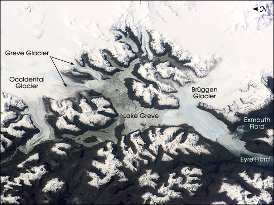
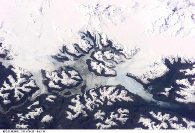
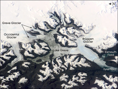
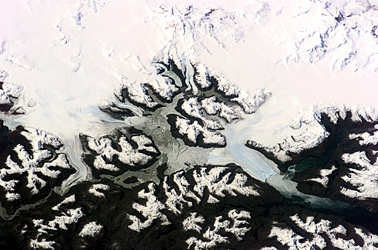
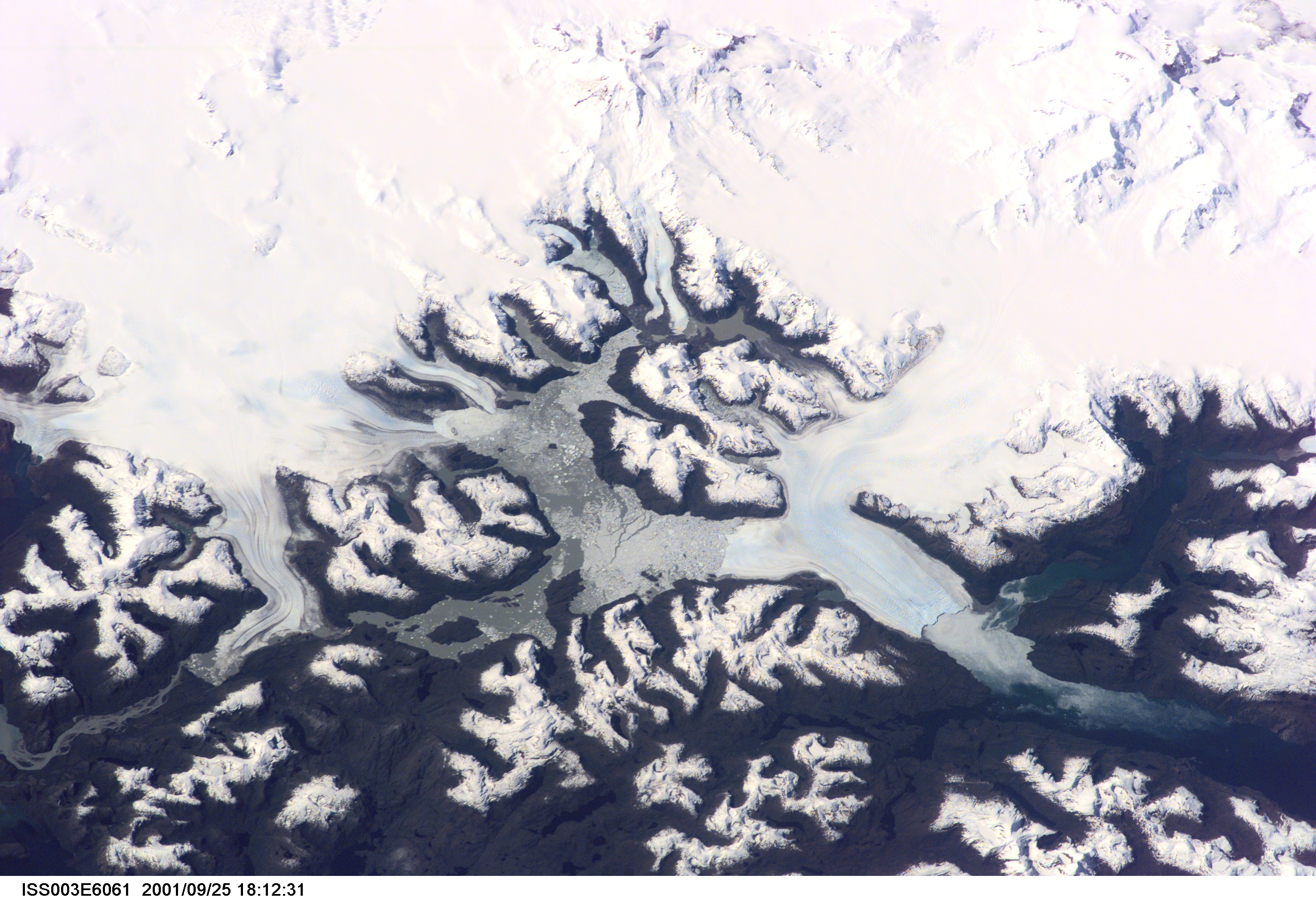
Mission: ISS003 Roll: E Frame: 6061 Mission ID on the Film or image: ISS003Country or Geographic Name: CHILE
Features: BRUGGEN GLACIER, EYRE FJORD
Center Point Latitude: -49.0 Center Point Longitude: -74.0 (Negative numbers indicate south for latitude and west for longitude)
Stereo: (Yes indicates there is an adjacent picture of the same area)
ONC Map ID: JNC Map ID:
Camera
Camera Tilt: High ObliqueCamera Focal Length: 180mm
Camera: E2: Kodak DCS460 Electronic Still Camera
Film: 3060E : 3060 x 2036 pixel CCD, RGBG array.
Quality
Film Exposure:Percentage of Cloud Cover: 10 (0-10)
Nadir
Date: 20010925 (YYYYMMDD)GMT Time: 171931 (HHMMSS)Nadir Point Latitude: -50.5, Longitude: -69.1 (Negative numbers indicate south for latitude and west for longitude)
Nadir to Photo Center Direction: West
Sun Azimuth: 343 (Clockwise angle in degrees from north to the sun measured at the nadir point)
Spacecraft Altitude: 214 nautical miles (396 km)
Sun Elevation Angle: 40 (Angle in degrees between the horizon and the sun, measured at the nadir point)
Orbit Number: 278
Captions
The Expedition 3 crew of the International Space Station caught a rare glimpse of the massive ice fields and glaciers of Patagonia early in the afternoon on September 25, 2001. This part of the South American coast sees frequent storms and is often obscured from view by cloud cover.Brüggen Glacier in southern Chile is the largest western outflow from the Southern Patagonian Ice Field and, unlike most glaciers worldwide, advanced significantly since 1945. From 1945 to 1976, Brüggen surged 5 km across the Eyre Fjord, reaching the western shore by 1962 and cutting off Lake Greve from the sea. The glacier continued advancing both northward and southward in the fjord to near its present position before stabilizing. The growth covers a distance of more than 10 km north to south, adding nearly 60 square km of ice.
Download Packaged File.
This option downloads the following items, packaged into a single file, if they are available:
- Browse image
- Cataloged information with captions
- Camera file
- Sound file
Server: 2 |
This service is provided by the International Space Station program. |
Recommended Citation: |
||

