| Home >> | Advanced Search >> |
 |
|
Astronaut Photography of Earth - Display Record
ISS010-E-23451

Low-resolution Browse Image
(Most browse images are not color adjusted.)Images
Conditions for Use of Images >>Image Transformation Tutorial >> Saving, Color Adjusting, and Printing Images >>
Images to View on Your Computer Now
| File Name | File Size (bytes) | Width | Height | Annotated | Cropped | Purpose | Comments | |
|---|---|---|---|---|---|---|---|---|
| View | ISS010-E-23451.JPG | 44496 | 639 | 435 | No | No | ||
| View | ISS010-E-23451.JPG | 329879 | 540 | 356 | Yes | Yes | NASA's Earth Observatory web site |
Large Images to Request for Downloading
| File Name | File Size (bytes) | Width | Height | Annotated | Cropped | Purpose | Comments | |
|---|---|---|---|---|---|---|---|---|
| Request | ISS010-E-23451.JPG | 911200 | 3032 | 2064 | No | No | ||
| Request | ISS010-E-23451.JPG | 1115213 | 1000 | 660 | No | Yes | NASA's Earth Observatory web site |
Download a Keyhole Markup Language (KML) file for use in Google Earth.
Electronic Image Data
Camera Files >> No sound file available.Identification
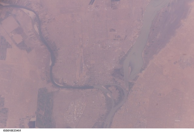
Mission: ISS010 Roll: E Frame: 23451 Mission ID on the Film or image: ISS010Country or Geographic Name: SUDAN
Features: WHITE NILE,BLUE NILE, KHARTOUM
Center Point Latitude: 15.6 Center Point Longitude: 32.5 (Negative numbers indicate south for latitude and west for longitude)
Stereo: (Yes indicates there is an adjacent picture of the same area)
ONC Map ID: JNC Map ID:
Camera
Camera Tilt: 37Camera Focal Length: 400mm
Camera: E4: Kodak DCS760C Electronic Still Camera
Film: 3060E : 3060 x 2036 pixel CCD, RGBG array.
Quality
Film Exposure:Percentage of Cloud Cover: 10 (0-10)
Nadir
Date: 20050407 (YYYYMMDD)GMT Time: 132740 (HHMMSS)Nadir Point Latitude: 13.5, Longitude: 33.7 (Negative numbers indicate south for latitude and west for longitude)
Nadir to Photo Center Direction: Northwest
Sun Azimuth: 269 (Clockwise angle in degrees from north to the sun measured at the nadir point)
Spacecraft Altitude: 194 nautical miles (359 km)
Sun Elevation Angle: 36 (Angle in degrees between the horizon and the sun, measured at the nadir point)
Orbit Number: 457
Captions
Khartoum, SudanSudan’s capital city, Khartoum, translates as “Elephant’s Trunk.” The name describes the shape of the Nile where the Blue and the White Nile Rivers unite to form the single Nile River that flows northward into Egypt. This image shows the rivers near the end of the dry season.
The White Nile (western branch) runs through Sudan from Uganda. The White Nile originates in equatorial regions, where rainfall occurs throughout the year; as a result, it runs at a nearly constant rate throughout the year. The Blue Nile, nearly dry this time of year, flows out of the Ethiopian highlands, where rainfall is more seasonal. The Blue Nile swells in the late summer and early fall with rains from the summer monsoons. The flow at these times can be so great that the volume is too much for the river's channel, causing the Nile to flow backward at the junction. In recent years, floods in Khartoum have occurred in August with heavy monsoon rainfall.
Khartoum is one of the largest Muslim cities in North Africa, but it has a fairly short history. Founded as a military outpost in 1821, a Sudanese flag has only flown over the city since 1956. Today, Khartoum is home to more than a million people, including many refugees, both from neighboring countries as well as from an ongoing civil war in southern Sudan. The city has a low profile, dominated by sprawling areas of small buildings that are supported by little infrastructure.
Download Packaged File.
This option downloads the following items, packaged into a single file, if they are available:
- Browse image
- Cataloged information with captions
- Camera file
- Sound file
Server: 2 |
This service is provided by the International Space Station program. |
Recommended Citation: |
||

