|
||
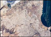
Anti-Atlas Mountains, Morocco
| ||||
The Anti-Atlas Mountains of northern Africa and the nearby Atlas mountains were created by the prolonged collision of the African and Eurasian tectonic plates, beginning about 80 million years ago. Massive sandstone and limestone layers have been crumpled and uplifted more than 4,000 meters in the High Atlas and to lower elevations in the Anti-Atlas. Between more continuous major fold structures, such as the Jbel Ouarkziz in the southwestern Anti-Atlas, tighter secondary folds (arrow) have developed. Earlier, the supercontinent of Pangea rifted apart to form precursors to the Mediterranean and the Atlantic Ocean (Beauchamp and others, 1996). In those seas sands, clays, limey sediments, and evaporite layers (gypsum, rock salt) were deposited. Later, during the mountain-building plate collision, the gypsum layers flowed under the pressure and provided a slippery surface on which overlying rigid rocks could glide (Burkhard, 2001). The broad, open style of folds seen in this view is common where evaporites are involved in the deformation. Other examples can be found in the Southern Zagros of Iran and the Sierra Madre Oriental of Mexico. Information Sources:
STS108-711-25 was taken in December, 2001 by the crew of Space Shuttle mission 108 using a Hasselblad camera with 250-mm lens. The image is provided by the Earth Sciences and Image Analysis Laboratory at Johnson Space Center. Additional images taken by astronauts and cosmonauts can be viewed at the NASA-JSC Gateway to Astronaut Photography of Earth. Recommend this Image to a Friend Back to: Newsroom
Also see |
View Images Index
| |||
|
Subscribe to the Earth Observatory About the Earth Observatory Contact Us Privacy Policy and Important Notices Responsible NASA Official: Lorraine A. Remer Webmaster: Goran Halusa We're a part of the Science Mission Directorate |
 Click here to view full image