 NCDC / Climate Mon. / Climate-2005 / Sep / U.S. Drought / Regional / Help NCDC / Climate Mon. / Climate-2005 / Sep / U.S. Drought / Regional / Help
Climate of 2005 - September
U.S. Regional Drought Watch
National Climatic Data Center, 11 October 2005
|
Global Analysis /
Global Hazards /
United States /
U.S. Drought /
National Drought Overview /
Extremes
Use these links to access detailed analyses of Global and U.S. data.
Regional Drought Overview /
Additional Contacts /
Questions

 Regional Overview Regional Overview
|
September 2005 was drier than normal across much of the country, with 13 percent of the contiguous U.S. very dry (in the bottom 10 percentile of the historical record). Especially dry areas included the Southeast to southern New England, and much of the Great Plains and Far West.
Rains from cold fronts and tropical systems brought short-term relief to the drought areas from Arkansas to the Great Lakes.
The September precipitation pattern at the primary stations in Alaska was mostly wetter than average. Across Hawaii, the precipitation pattern was mixed, with more stations wetter than average than drier. In Puerto Rico, the precipitation signal was also mixed, based on National Weather Service radar estimates of precipitation. September streamflow averaged near normal for Puerto Rico and wetter than normal for the Hawaiian Islands.
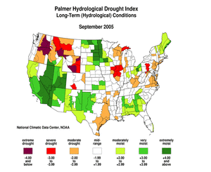
Many of these September dry areas have been drier than normal for the last 2 to 6 to 9 months. Long-term moisture deficits (last 24 to 36 to 60 months) persisted across parts of the West into the northern High Plains and central Plains.
|
Some regional highlights:
- Three states had the driest September in the 111-year record:
- Four additional states had the tenth driest, or drier, September:
- Six states had the tenth driest, or drier, August-September:
- Four states had the tenth driest, or drier, July-September:
- Illinois ranked tenth driest, or drier, for several seasons:
- Apr-Sep: 10th driest
- Mar-Sep: 6th driest
- Feb-Sep: 6th driest
- During September, parts of Kansas and eastern Iowa were declared drought disaster areas by the USDA (High Plains Journal, 9/21; Quad-City Times, 9/14). In parts of North Carolina, some public water supply systems were under voluntary water conservation during the month because of drought related issues.
- By the end of the month, 60% or more of the pasture and range land was in poor to very poor condition in Arkansas (61%), Connecticut (71%), Louisiana (76%), Pennsylvania (78%), California (86%), and Rhode Island (100%).
- End-of-month and month-averaged soil moisture conditions were drier than normal across a broad swath from the mid-Atlantic to southern New England states, much of the Great Lakes region into the central Plains, and parts of the southern Plains, Pacific Northwest, and northern and central Rockies, based on model computations (CPC-1, CPC-2, MRCC). The models also indicated dry soil moisture conditions in parts of Alaska and Hawaii, and near the surface and at depth from Iowa to the western Great Lakes.
- According to early October USDA observations, more than 50 percent of the topsoil moisture was rated short to very short (dry to very dry) across the Pacific Northwest and Rocky Mountain states, parts of the central and southern Plains, and from the Southeast to southern New England states. This is drier than the 5-year and 10-year averages across much of the area.
- Streamflow levels were below seasonal norms across much of the Southeast to southern New England states, and parts of the Pacific Northwest, northern and central Rockies, central and southern Plains, and Great Lakes, as computed by models and based on USGS observations.

|
|
- These overall conditions are evident in the following indicators:
- Palmer Drought Indices,
- Standardized Precipitation Index,
- long-term (36 to 60 month) percent of normal precipitation maps,
- airport station percent of normal precipitation maps,
- statewide precipitation rank maps,
- Cooperative station percent of normal precipitation maps,
- percent of average maps for the SNOTEL stations in the western mountains provided by the Western Regional Climate Center
- satellite-based observations of vegetative health,
- National Weather Service model calculations of
- National Weather Service model calculations of soil moisture using the Leaky Bucket Model,
- Midwest Regional Climate Center model calculations of soil moisture,
- topsoil moisture conditions observed by the USDA and mapped by the Climate Prediction Center,
- pasture and range land conditions observed by the USDA and mapped by the Climate Prediction Center,
- streamflow maps maintained by the USGS.
- A detailed review of drought and moisture conditions is available for all contiguous U.S. states and the nine climatological regions:
REGIONS:
 STATES:
- Wildfire activity continued across the western U.S. during September, as numerous large fires burned in Alaska, the northern Rockies, and Columbia Plateau regions. As reported by the National Interagency Fire Center, over 8.1 million acres had burned across the U.S. by the end of the month, ranking the 2005 season as the second highest since 1960 for acres burned, just 0.3 million acres behind 2000.
- Reservoir levels in the West (provided by the USDA) reflected the long-term precipitation deficits in many states. About 16 percent of the western U.S. (Rockies westward) fell in the moderate to extreme drought category (as defined by the Palmer Drought Index) as of the end of September, reflecting continued dryness in the Pacific Northwest (June, July, August, September).
|
Additional Contacts:
|
- For all climate questions other than questions concerning this report, please contact the National Climatic Data Center's Climate Services Division:
Climate Services Division
NOAA/National Climatic Data Center
151 Patton Avenue
Asheville, NC 28801-5001
fax: 828-271-4876
phone: 828-271-4800
email: ncdc.info@noaa.gov
- For further information on the historical climate perspective presented in this report, contact:
Richard Heim
NOAA/National Climatic Data Center
151 Patton Avenue
Asheville, NC 28801-5001
fax: 828-271-4328
email: Richard.Heim@noaa.gov
-or-
Jay Lawrimore
NOAA/National Climatic Data Center
151 Patton Avenue
Asheville, NC 28801-5001
fax: 828-271-4328
email: Jay.Lawrimore@noaa.gov
|
NCDC / Climate Mon. / Climate-2005 / Sep / U.S. Drought / Regional / Help
|


