| Home >> | Advanced Search >> |
 |
|
Astronaut Photography of Earth - Display Record
ISS007-E-15149
Low-resolution Browse Image
(Most browse images are not color adjusted.)Images
Conditions for Use of Images >>Image Transformation Tutorial >> Saving, Color Adjusting, and Printing Images >>
Images to View on Your Computer Now
| File Name | File Size (bytes) | Width | Height | Annotated | Cropped | Purpose | Comments | |
|---|---|---|---|---|---|---|---|---|
| View | ISS007-E-15149.JPG | 85023 | 540 | 405 | Yes | Yes | NASA's Earth Observatory web site | |
| View | ISS007-E-15149.JPG | 85023 | 540 | 405 | Yes | Yes | NASA's Earth Observatory web site | |
| View | ISS007-E-15149.JPG | 88440 | 540 | 358 | Photographic Highlights | (resized 540 px images) | ||
| View | ISS007-E-15149.JPG | 110063 | 639 | 435 | No | No | ||
| View | ISS007-E-15149_2.JPG | 309101 | 999 | 662 | Photographic Highlights | (actual files used) | ||
| View | ISS007-E-15149.JPG | 470607 | 1000 | 662 | No | Yes | NASA's Earth Observatory web site | Color adjusted |
Large Images to Request for Downloading
| File Name | File Size (bytes) | Width | Height | Annotated | Cropped | Purpose | Comments | |
|---|---|---|---|---|---|---|---|---|
| Request | ISS007-E-15149.JPG | 1712905 | 3032 | 2064 | No | No | ||
| Request | ISS007-E-15149_2.JPG | 8139065 | 6144 | 4068 | No | No | Presentation | Earth Sciences Results Briefing/Ed Lu |
Download a Keyhole Markup Language (KML) file for use in Google Earth.
Electronic Image Data
Camera Files >> No sound file available.Identification
Mission: ISS007 Roll: E Frame: 15149 Mission ID on the Film or image: ISS007Country or Geographic Name: REPUBLIC SOUTH AFRICA
Features: JOHANNESBURG, ROADS, SUBURBS
Center Point Latitude: -26.0 Center Point Longitude: 28.0 (Negative numbers indicate south for latitude and west for longitude)
Stereo: (Yes indicates there is an adjacent picture of the same area)
ONC Map ID: JNC Map ID:
Camera
Camera Tilt: 30Camera Focal Length: 400mm
Camera: E4: Kodak DCS760C Electronic Still Camera
Film: 3060E : 3060 x 2036 pixel CCD, RGBG array.
Quality
Film Exposure:Percentage of Cloud Cover: 10 (0-10)
Nadir
Date: 20030921 (YYYYMMDD)GMT Time: 132646 (HHMMSS)Nadir Point Latitude: -26.5, Longitude: 29.9 (Negative numbers indicate south for latitude and west for longitude)
Nadir to Photo Center Direction: West
Sun Azimuth: 289 (Clockwise angle in degrees from north to the sun measured at the nadir point)
Spacecraft Altitude: 206 nautical miles (382 km)
Sun Elevation Angle: 32 (Angle in degrees between the horizon and the sun, measured at the nadir point)
Orbit Number: 3605
Captions
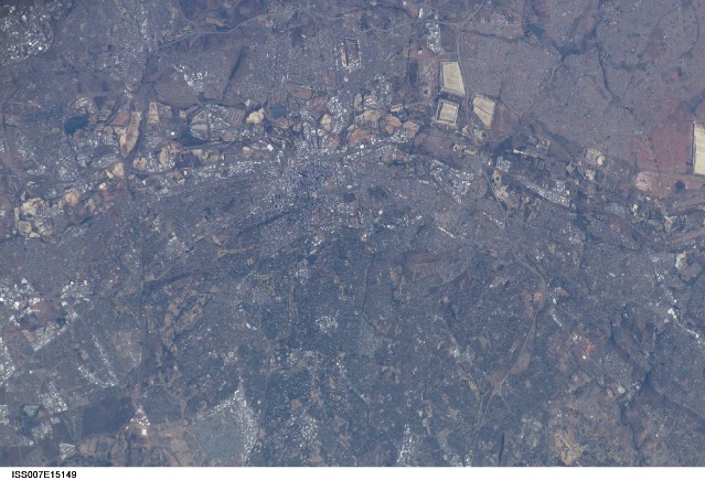
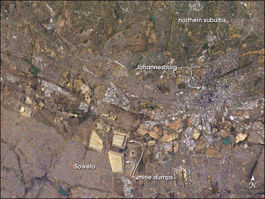
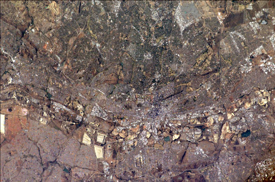
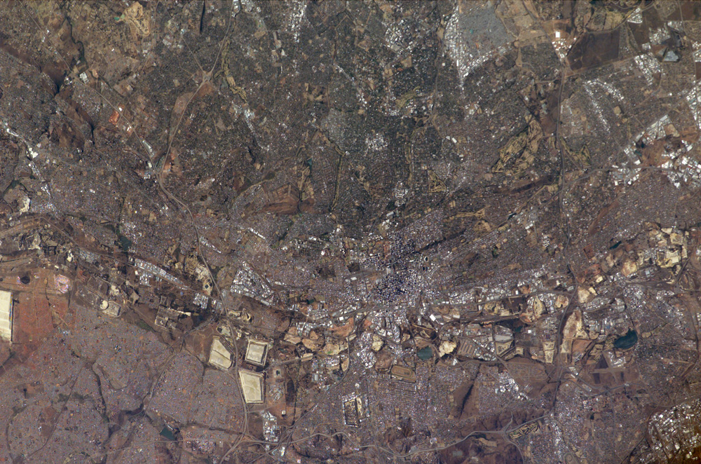
Johannesburg, South Africa: Why are cities established where they are? How do local economies and politics influence patterns of human settlement and development at such a grand scale that these patterns can be identified from space? This photograph of Johannesburg, South Africa, taken from the International Space Station illustrates the human geography of the region.In this case, the cityscape of Johannesburg is the most difficult pattern to discern. The center of Johannesburg is the fine-grained pattern (created by shadows cast from the high rise buildings in the city) in the center of this mosaic. On the southern fringe of Johannesburg is a line of light colored, angular patches stretching across the scene. These patches are the great “mine dumps” (an example is arrowed), the crushed rock that remains after gold extraction from numerous gold mines. These are the mines that underpinned the South African economy for decades, and their dumps, or tailing piles, are the visuals that orbiting crews see when they overfly Johannesburg and neighboring cities, delineating the east-west outcrop of the gold–rich rock strata discovered in 1886. Some mine dumps are so large that an outdoor movie theater was located on one of them. Neighboring industrial cities are nestled among the mine dumps as far as the edges of the photograph. Older mine dumps nearer the Johannesburg city center have disappeared from view in the last 25 years, having been re-mined for the gold that remained within them.
The green zone (top right) is the leafy northern suburbs, where hundreds of square miles of grassland have been progressively forested since Johannesburg was founded in 1886. Small light patches within the tree-rich zone are satellite businesses and shopping centers, typical of any major western city. By contrast, a major ghetto (established by the former South African government) typical of developing-world urban migration, appears as the grey zone lower left (the famous Soweto Township). Soweto appears largely treeless except for protected valley bottoms.
Download Packaged File.
This option downloads the following items, packaged into a single file, if they are available:
- Browse image
- Cataloged information with captions
- Camera file
- Sound file
Server: 2 |
This service is provided by the International Space Station program. |
Recommended Citation: |
||

