| Home >> | Advanced Search >> |
 |
|
Astronaut Photography of Earth - Display Record
ISS013-E-19323
Low-resolution Browse Image
(Most browse images are not color adjusted.)Images
Conditions for Use of Images >>Image Transformation Tutorial >> Saving, Color Adjusting, and Printing Images >>
Images to View on Your Computer Now
| File Name | File Size (bytes) | Width | Height | Annotated | Cropped | Purpose | Comments | |
|---|---|---|---|---|---|---|---|---|
| View | ISS013-E-19323.JPG | 108162 | 639 | 435 | No | No | ||
| View | ISS013-E-19323.JPG | 304622 | 540 | 362 | Yes | Yes | NASA's Earth Observatory web site |
Large Images to Request for Downloading
| File Name | File Size (bytes) | Width | Height | Annotated | Cropped | Purpose | Comments | |
|---|---|---|---|---|---|---|---|---|
| Request | ISS013-E-19323.JPG | 762615 | 1000 | 671 | No | Yes | NASA's Earth Observatory web site | |
| Request | ISS013-E-19323.JPG | 1271175 | 3032 | 2064 | No | No |
Download a Keyhole Markup Language (KML) file for use in Google Earth.
Electronic Image Data
Camera Files >> No sound file available.Identification
Mission: ISS013 Roll: E Frame: 19323 Mission ID on the Film or image: ISS013Country or Geographic Name: USA-TEXAS
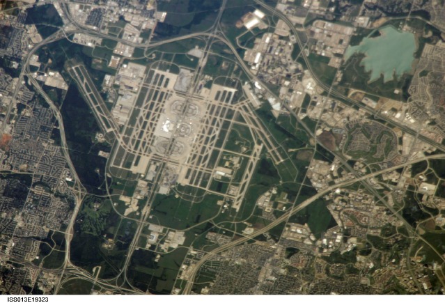
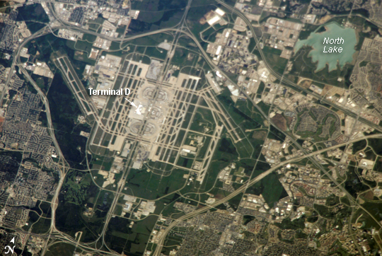
Features: DALLAS-FORT WORTH AIRPORT
Center Point Latitude: 32.9 Center Point Longitude: -97.0 (Negative numbers indicate south for latitude and west for longitude)
Stereo: (Yes indicates there is an adjacent picture of the same area)
ONC Map ID: JNC Map ID:
Camera
Camera Tilt: 34Camera Focal Length: 800mm
Camera: E4: Kodak DCS760C Electronic Still Camera
Film: 3060E : 3060 x 2036 pixel CCD, RGBG array.
Quality
Film Exposure:Percentage of Cloud Cover: 10 (0-10)
Nadir
Date: 20060513 (YYYYMMDD)GMT Time: 173755 (HHMMSS)Nadir Point Latitude: 34.5, Longitude: -98.3 (Negative numbers indicate south for latitude and west for longitude)
Nadir to Photo Center Direction: Southeast
Sun Azimuth: 141 (Clockwise angle in degrees from north to the sun measured at the nadir point)
Spacecraft Altitude: 186 nautical miles (344 km)
Sun Elevation Angle: 70 (Angle in degrees between the horizon and the sun, measured at the nadir point)
Orbit Number: 2773
Captions
Dallas-Fort Worth International Airport, TXThe largest airport in Texas, Dallas-Fort Worth International (DFW) is also the fourth largest in the world, and it occupies more surface area than the entire island of Manhattan in New York. The airport is officially owned by the cities of Dallas and Fort Worth, but it is sited within the city limits of four neighboring cities (Coppell, Euless, Grapevine, and Irving). This situation of multiple jurisdictions has led to legal battles over expansion since the airport was opened in 1974, and the addition of new runways required a U.S. Supreme Court decision in 1994. Over fifty-nine million passengers and approximately eight hundred thousand tons of cargo passed through the airport in 2005.
This oblique astronaut photograph (oblique means the viewing angle is not vertical relative to the Earth’s surface beneath the International Space Station) captures the entire airport and portions of the surrounding Dallas-Fort Worth metropolitan area. The white rooftops of the new International Terminal D (completed in 2005) are also distinct from less reflective rooftops of the older terminals. A sense of the size of the airport is provided by the approximately 2,800-meter-long, northwest-southeast runway to the west of Terminal D (2,800 meters is about 1.7 miles). The oblique viewing angle also accentuates light reflection off of North Lake (upper right), giving the water surface a grey-green cast.
Download Packaged File.
This option downloads the following items, packaged into a single file, if they are available:
- Browse image
- Cataloged information with captions
- Camera file
- Sound file
Server: 2 |
This service is provided by the International Space Station program. |
Recommended Citation: |
||

