 Climate Monitoring / Climate of 2008 / August / U.S. Climate / Help Climate Monitoring / Climate of 2008 / August / U.S. Climate / Help
U.S. National Overview
August 2008
National Climatic Data Center
Asheville, North Carolina
Updated 11 September 2008
|
Global Analysis / Global Hazards /
United States / U.S. Drought /
Extremes
![[------- visual page separator -------]](https://webarchive.library.unt.edu/eot2008/20080921115959im_/http://www.ncdc.noaa.gov/img/climate/research/1998/bluebar.gif)
Maps and Graphics:
PLEASE NOTE: All temperature and precipitation ranks and values are based on preliminary data. The ranks will change when the final data are processed, but will not be replaced on these pages. As final data become available, the most up-to-date statistics and graphics will be available on the Climate Monitoring Products page and the U.S. Climate at a Glance Web site.
For graphics covering periods other than those mentioned above or for tables of national, regional, and statewide data from 1895—present, for August, last 3 months or other periods, please go to the Climate at a Glance page.
National Overview:
Temperature Highlights
- For the contiguous United States, the average temperature for August was 73.2°F (22.9°C), which was 0.4°F (0.3°C) above the 20th century mean and ranked as the 39th warmest August on record, based on preliminary data.
- On the Regional level, much of the U.S. experienced warmer than normal temperatures during August. The Northeast, Central, and South regions had below average temperatures and the West region experienced above average temperatures.
- Using the Residential Energy Demand Temperature Index (REDTI - an index developed at NOAA to relate energy usage to climate), the nation's residential energy demand during August was approximately 3.5% below average consumption and ranked as the 45th lowest in 114 years.
Precipitation Highlights
- This was the 9th wettest August in the 1895—2008 record. An average of 3.1 inches (79 mm) fell across the contiguous U.S. this month, which is 0.5 inches (13 mm) above average.
- Precipitation in August was much above normal for the South and Southeast Regions. In contrast, the East North Central and Central Regions of the U.S. had their 6th and 11th driest respective, Augusts on record.
- Eight states (CO, TX, AR, LA, MS, AL, GA, FL) were much wetter than average for August. MS had its all-time wettest August, and FL and AL their 2nd wettest August on record.
- Seven states (DE, IA, IN, KY, OH, MI, WI) were much drier than average for August. DE had its all-time driest August, and KY and WI their 3rd and 6th driest Augusts on record respectively.
Other Items of Note
-
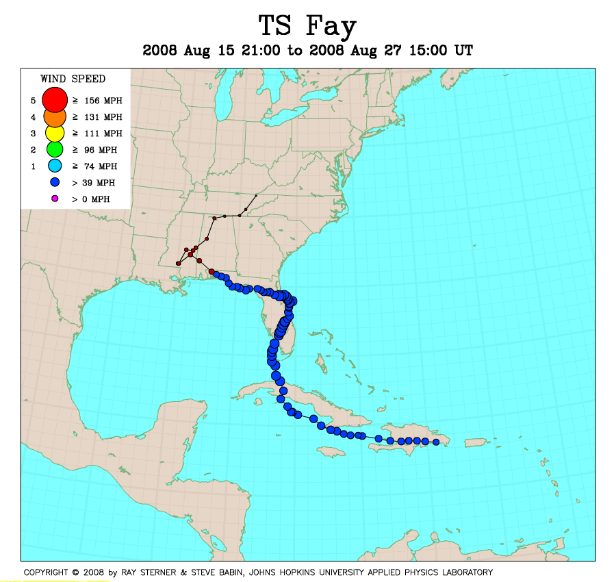
Extensive flooding was reported in parts of Florida due to heavy rains from Tropical Storm Fay. Jacksonville and Tallahassee each recorded 16.50 inches (419 mm) of rain, making this past month the wettest August on record for those cities. Thomasville, GA totaled 27.50 inches (699 mm) in August, while Fort Pierce, FL and Orlando, FL broke their all-time 24-hr precipitation records on August 19 with 8.8 inches (225 mm) and 8.2 inches (209 mm), respectively. A 3-day (August 20-22) record 18.4 inches (469 mm) of rain fell at the National Weather Service office in Melbourne, FL. By the end of August, 27% of the contiguous U.S. was classified in moderate-to-extreme wet spell conditions compared to 28% a month ago, based on the Palmer Index. For additional information on Tropical Storm Fay, please visit NCDC's Atlantic Hurricane Season monitoring page or the National Hurricane Center.
-
Severe weather in the Chicago area on the 4th left nearly a half million residents without power, spawned at least 3 tornadoes and prompted travelers at O'Hare airport to be evacuated to lower levels and a sell-out crowd at Wrigley Field to seek shelter in interior concourses. Nearly 350 flights were cancelled at the O'Hare.
-
Four named Atlantic tropical storms developed in August, all of which made landfall in the United States. Tropical Storm Edouard began the month, forming on August 3 and making landfall near Port Arthur, TX on August 5. Tropical Storm Fay formed on August 15 and made an initial landfall at Key West, FL on August 18. Over the next 6 days, Fay became the first storm on record to make 4 landfalls in Florida. Hurricane Gustav pounded several Caribbean nations before making landfall west of Grand Isle, LA on September 1 as a Category 3 storm. Gustav claimed an estimated 120 lives, including 25 in the U.S., and resulted in an estimated several billion dollars in damage, which makes Gustav likely the 4th most costly hurricane on record. Hurricane Hanna closed the month, forming on August 28 and made landfall in South Carolina on September 6. August sees an average of 3 Atlantic/Caribbean tropical cyclones and on average 1 makes landfall in the U.S. every 2.3 years.
- Wildfires scorched parts of a dozen states during August, primarily in the northwestern United States. As of August 29th, 64,034 wildfires have burned more than 4.5 million acres of the U.S., according to statistics from the National Interagency Fire Center. While the number of fires was above the 1999-2008 average, the acreage burnt was approximately one million acres less than normal for the year-to-date. For additional information on wildfire conditions, please visit the NCDC Wildfire Monitoring page.
- ENSO-neutral conditions were present in the equatorial Pacific Ocean by the end of August. Equatorial sea-surface temperatures were near-average in the central Pacific while positive sea-surface temperature anomalies have decreased in the eastern Pacific. Based upon recent trends and models, the CPC is forecasting ENSO-neutral conditions to continue through the Northern Hemisphere Fall 2008. These conditions increase the probability of above normal temperatures for much of the Midwestern U.S. as well as the Northeast. The conditions also increase the chances of above normal precipitation for the Gulf Coast states as well as the northeast. For additional information on ENSO conditions, please visit the NCDC ENSO Monitoring page and the latest NOAA ENSO Advisory.
Alaska:
- Alaska had its 43rd warmest August since records began in 1918, with a temperature 0.7°F (0.4°C) below the 1971—2000 average.
- Alaska had its 41st coolest June—August on record, with a temperature 1.0°F (0.6°C) below the 1971—2000 average.
- Alaska had its 33rd warmest January—August on record, with a temperature 0.4°F (0.2°C) below the 1971—2000 average.
For additional details about recent temperatures and precipitation across the U.S., see the Regional Highlights section below and visit the August Climate Summary page.
For information on local temperature and precipitation records during the month of August, please visit NCDC's Extremes page.
For details and graphics on weather events across the U.S. and the globe please visit NCDC's Global Hazards page.
|
Regional Highlights:
Northeast Region: (Information provided by the Northeast Regional Climate Center)
-
Temperatures in the Northeast during the last month of summer averaged 66.6°F (19.2°C), which was 1.4°F (0.8°C) below normal. This was 2.7°F (1.5°C) cooler than August 2007 and it was the coolest August since 1997. All of the states in the region had below-average temperatures during the month. Departures ranged from 0.6°F (0.3°C) below normal in Maine to 2.4°F (1.3°C) below normal in Maryland.
-
Once again, the northern states were wetter than the southern half of the region, but not as wet overall as last month. In fact, the Northeast region, as a whole, averaged below normal precipitation in August. The region's average rainfall total of 3.6 inches (9 mm) was 90% of normal. New Hampshire and Vermont saw the most rain, 127% and 118% of normal, respectively. It was the driest August in 114 years in Delaware, where only 1.0 inches (25 mm) of rain fell. Delaware's August total was 3.6 inches (93 mm) below normal.
-
The Drought Monitor issued on September 2, 2008 indicated that the southernmost parts of New Jersey and West Virginia eastern Maryland, a small area in north central Pennsylvania and most of Delaware were experiencing moderate drought conditions. The rest of New Jersey, central and southeastern Pennsylvania, central Maryland and southern West Virginia were abnormally dry. In contrast, Maine, New Hampshire, Vermont, Connecticut, eastern New York, western Pennsylvania and all but coastal Massachusetts were in the unusual or very moist categories of the Palmer Drought Severity Index.
For more information, please go to the Northeast Regional Climate Center Home Page.
Midwest Region: (Information provided by the Midwest Regional Climate Center)
-
Temperatures across the Midwest were generally below normal during the month, with the coolest area in north-central Missouri where departures were 3°F (1.7°C) below normal. The central Midwest also had average daily maximum temperatures that ranged 3°F - 5°F (1.7°C - 2.8°C) below normal. The warmest area was a band across the northern and eastern portions of the region, where temperatures were near normal to 1.5°F (0.8°C) above normal. Repeated intrusions of cooler, drier air kept the normally muggy August weather at bay and only a few humid periods occurred during the month.
-
August was a very dry month across the Midwest. Precipitation was below normal across the entire region, with only a few isolated areas receiving near normal rainfall. In those areas that did receive normal rainfall, much of the rain was not spread out across the month but came during one or two events. Rainfall in August was less than 25 percent of normal from northern Minnesota through northern Wisconsin into northwestern Ohio, as well as the Ohio Valley. The only area to receive normal to above normal rainfall was extreme southern Missouri and parts of central Missouri. For most of the region, August rainfall totals were well below two inches (51 mm). By the end of the month the U.S. Drought Monitor was depicting areas of Moderate Drought (D1) in Minnesota, Wisconsin, and southeastern Kentucky. Abnormal Dryness (D0) expanded across Ohio, Michigan, and Wisconsin.
- Severe weather occurred on an occasional and scattered basis during the month. A strong "bow echo" system raced through northern Illinois and Indiana on August 4 causing widespread wind damage. In Illinois the most significant damage was in the Chicago area and suburbs. Commonwealth Edison reported that 427,000 customers were affected by the storm, with 238,000 still without power on the morning of August 5. At least three tornadoes were confirmed in northeastern Illinois, and a wind gust of 94 mph (151 kph) was recorded by an automated station located at the Harrison Crib in Lake Michigan about 4 miles NNE of downtown Chicago. A sellout crowd of 40,867 at Wrigley Field for the Chicago Cubs-Houston Astros game was directed to seek shelter in the stadium concourse areas when tornado sirens went off at 8:09 pm CDT. Passengers at Chicago's O'Hare Airport were evacuated to the lower level of the terminals when the storms hit, and 350 flights were canceled. A 23 year-old man was killed in La Porte County, IN when a tree toppled by high winds fell on his car. A confirmed EF2 tornado touched down in Griffith, IN about 8:40 pm CDT, producing at least a five-mile path of damage. A second Indiana tornado (EF0) was confirmed in Boswell. The only other significant severe weather occurrence was on August 28 when severe thunderstorms rolled through northern and central Missouri and into western Illinois, producing wind damage and locally heavy rain. There were no tornadoes reported in the nine-state Midwest region during the last half of the month.
For details on the weather and climate events of the Midwest during August, see the weekly summaries in the MRCC Midwest Climate Watch page.
Southeast Region: (Information provided by the Southeast Regional Climate Center)
-
Similar to July, average temperatures for August 2008 were within 2°F (1°C) of normal over much of the region. During the first 7 to 10 days, a southwesterly to westerly flow persisted across much of the southeast resulting in hot conditions. Roughly 90% of the record high temperatures for the month occurred during this period. Camp Hill, AL and Eastman, GA each recorded a record high of 102°F (39°C) on August 7th. With the passage of several cold fronts, a cooler regime developed during the second week and persisted until August 20th across the region, except for Florida. There were over 100 record low temperatures observed during this period. Clayton, GA and Waynesville, NC each recorded record lows of 51°F (11°C) and 45°F (7°C), respectively, on August 7th. Temperatures in Puerto Rico were several degrees above normal as San Juan recorded record high temperatures on two days during the month.
-
In contrast to prior months, over three-quarters of the region received above normal rainfall. Huntsville, AL recorded above normal monthly precipitation for the first time since October 2006, ending a stretch of 21 normal or dry months. Most of Florida and Alabama, as well southern Georgia, central North Carolina and portions of southern Virginia received more than 150% of normal precipitation for the month. Jacksonville and Tallahassee, FL each recorded over 16.5 inches (419 mm) of precipitation, making it the wettest August on record for these two sites. Much of this precipitation was connected with Tropical Storm Fay, who tracked slowly across FL, southern AL, and MS between August 18 and 23 before weakening into a tropical depression and moving slowly northeastward into eastern TN and KY by August 27th. Fay and her remnants affected portions of the Southeast over a 10-day period in the second half of August. Due to Fay's slow motion, storm precipitation totals were quite impressive in places. Thomasville, GA and Melbourne, FL, for example, recorded monthly totals of 27.5 inches (699 mm) and 19.6 inches (498 mm), respectively. Additionally, Concord, NC broke its all time 24 hour precipitation record with a total of 8.8 inches (224 mm). Heavy precipitation was also observed in connection with an extratropical cyclone that tracked unusually far south across the region on August 13th. Broad areas of AL, GA, SC, and southern NC received rainfall totals between 1.5 - 6.0 inches (38 - 152 mm). Monthly precipitation totals in Puerto Rico during the month were quite variable.
-
Drought conditions persisted across portions of the region during the month of August. The heavy rainfall, however, reduced the drought intensity in most places by the end of the month. Exceptional drought conditions continued to plague northwestern South Carolina, northeast Georgia and western NC. Faye's rainfall, however, reduced the intensity of the drought slightly over all but northwestern SC. A broad area of severe to extreme drought persisted across eastern Alabama, Georgia, South Carolina, North Carolina, and Virginia, although Fay's rainfall reduced the intensity of the drought over much of the region with the exception of southeastern VA and northeastern NC. At least 89 tornadoes were observed across the region during August, but have not yet been officially confirmed. Approximately 68 of these tornadoes were associated with Fay and her remnants. This count, while not yet official, far surpasses the previous record of 37 tropical storm-spawned tornadoes associated with Tropical Storm Beryl in 1994.
For more information, please go to the Southeast Regional Climate Center Home Page.
High Plains Region: (Information provided by the High Plains Regional Climate Center)
-
Much of the region experienced their hottest days this month at the beginning August, with many stations setting records and reporting temperatures above 100°F (38°C). North Dakota and South Dakota, however, had their warmest days at the end of the month. The highest temperature in the region was 111°F (44°C), recorded at both Imperial, NE on August 2nd and at John Martin Dam, CO on August 4th. At both locations not only did this set a new record high temperature for the day, but also for the month. Interestingly, at John Martin Dam, CO, the 2nd all-time high for the month occurred two days earlier and the 3rd all time high for the month occurred just the day before. At Imperial, the previous record high for the day was 104°F (40°C) set back in 1970 and at John Martin Dam, CO the old record for the day of 103°F (39°C) was set back in 1980. The lowest temperature in the region, 20°F (-7°C), occurred at Darwin Ranch, WY on August 27th and ranked as the 4th all time low temperature for that day.
-
August 2008 was dry for portions of central and eastern Nebraska, western Colorado, northern Wyoming, and the Dakotas. As drought conditions continue in Wyoming, the paucity of precipitation in eastern Nebraska and South Dakota helped contribute to the development of abnormally dry and moderate drought conditions. However, heavy rains in eastern Colorado and western Kansas helped alleviate drought conditions there, with many locations receiving 150-300% of normal precipitation. Highlights of the precipitation totals include Greeley UNC, CO which received 7.0 inches (178 mm) and Alton, KS which received 9.4 inches (238 mm) of precipitation throughout the month. This resulted in Greeley UNC, CO receiving 595% and Alton, KS receiving 300% of their normal precipitation for the month of August. Far southeastern Wyoming also saw precipitation that was above 300% of normal. Cheyenne, WY saw an impressive 6.6 inches (166 mm) of precipitation, or 360% of normal.
-
At least four tornadoes were spotted August 24th in Douglas County Colorado which is just south of the Denver metro area. Only tree damage was reported.
For more information, please go to the High Plains Regional Climate Center Home Page.
Southern Region: (Information provided by the Southern Regional Climate Center)
-
Not available at this time.
For more information, please go to the Southern Regional Climate Center Home Page.
Western Region: (Information provided by the Western Regional Climate Center)
-
Temperatures in the West ranged from above normal in the Great Basin and the Southwest to below normal in the northwest, and much of Colorado and New Mexico. California was very warm inland, and cooler than usual along the coast. Reno, NV, Redding, CA, and Modesto, CA recorded their warmest August on record. An unusually cold storm hit the east side of the Front Range from Cheyenne, WY, to Pueblo, CO, on the 15th and 16th, with heavy rain and very cool temperatures. Cheyenne measured 2.1 inches (53 mm) of rain on the 15th with a high temperature of only 49°F (10°C). Their previous coolest maximum temperature for August 15th was 60°F (18°C), set in 1888. Anchorage continued with their cool summer as only 2 days have reached 70°F (21°C) so far. The previous low record through August is 3 days of 70°F or above, set in 1980.
-
Precipitation was above normal in western Washington and northwest Oregon, northern Idaho, and eastern Colorado while most of the intermountain west was below normal except for isolated pockets in Utah and the southwest. Phoenix, AZ, measured their 6th wettest August on record and the wettest since 1990, while Tucson had below normal rainfall for the month. Cheyenne's total of 6.6 inches (166 mm) is their 3rd wettest month on record going back 94 years, and just behind Aug 1930 (6.7 inches / 170 mm) and August 1985 (6.6 inches / 168 mm).
-
Strong thunderstorms in southern Nevada on the 7th produced flash flooding in Mountain Springs with 3 feet (90 cm) of water in some buildings. A 4-year old boy was knocked unconscious by lightning in Henderson and his mother was partially paralyzed by the strike. Many portions of Las Vegas were under water from this event. On the 17th, a flash flood occurred on the Havasupai Indian Reservation in Arizona, flooding the community of Supai. This was caused by heavy rain breaching the Redlands Dam some 45-50 miles (72-80 km) upstream. Although over 200 people were evacuated or rescued, there were no fatalities in the narrow canyon. In the town of Big River, CA, near the Colorado River, one person was trapped and killed as his vehicle was caught in a flash flood on the 25th. Also that day, one person died and 5 were injured near Bouse, AZ as their vehicle was swept away in a flash flood. On August 31, a climate station run by the Western Regional Climate Center atop White Mountain Summit, CA measured a daily mean speed of 60.6 mph (97.5 kph) and a gust of 96.5 mph (155.3 kph). Another station on the top of 12,327 ft (3757 m) Mt Warren, just east of Yosemite National Park, recorded a mean daily wind speed of 66.3 mph (29.6 m/s), and a peak gust of 109.4 mph (48.9 m/s), and five hours over 100 mph (44.7 m/s), a highly unusual wind speed for this season, though such winds are common in winter. Cottonwood trees were blown over north of Lee Vining, CA, and a kayaker drowned during reported 80 mph (128.7 kph) winds on adjoining Mono Lake.
For more information, please go to the Western Regional Climate Center Home Page.
|
See NCDC's Monthly Extremes web-page for weather and climate records for the month of August.
For additional national, regional, and statewide data and graphics from 1895-present, for August, the last 3 months or other periods, please visit the Climate at a Glance page.
PLEASE NOTE: All of the temperature and precipitation ranks and values are based on preliminary data. The ranks will change when the final data are processed, but will not be replaced on these pages. Graphics based on final data are provided on the Climate Monitoring Products page and the Climate at a Glance page as they become available.
For all climate questions other than questions concerning this report, please contact the National Climatic Data Center's Climate Services and Monitoring Division:
Climate Services and Monitoring Division
NOAA/National Climatic Data Center
151 Patton Avenue
Asheville, NC 28801-5001
fax: +1-828-271-4876
phone: +1-828-271-4800
email: ncdc.info@noaa.gov
To request climate data, please E-mail: ncdc.orders@noaa.gov
 top of the page top of the page
|
Climate Monitoring / August / U.S. Climate / Search / Help
|


