Skip all navigation and jump to content Jump to site navigation Jump to section navigation.
NASA Logo - Goddard Space Flight Center + Visit NASA.gov
HOME PROJECTS RESOURCES SEARCH MAP

+ Advanced Search
Home
Home
View Most Recently Released Imagery
View Gallery of Imagery: A topical collection of SVS Imagery
Search Imagery by the keywords assigned to it
Search Imagery by the instruments that supplied data for a visualization product
Search Imagery by the series of visualizations that have been produced
Search Imagery by the scientist providing the data used in a visualization product
Search Imagery by the animator that created the product
Search Imagery by the identification number assigned to the visualization product
See other search options
Learn about the SVS Image Server
  + About the Server
  + Animation List
  + How to Use the Server


  + RSS Feeds
blank image
Previous Animation
Next Animation
QuikSCAT Antarctic Sea Ice (WMS)

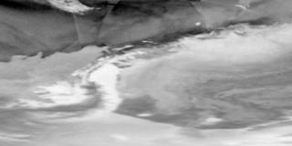
The sea ice around Antarctica grows dramatically from late February, when large parts of the coast are ice-free, to October, when the amount of sea ice effectively doubles the size of the continent. The SeaWinds Scatterometer instrument on the QuikSCAT satellite captures this dramatic ebb and flow and shows the sea ice as dynamic and always moving, even in areas that are ice-bound. This animation shows the sea ice around Antarctica from SeaWinds during 2004. SeaWinds can see individual icebergs if they are large enough, and a large iceberg can be seen for most of the year south of South America as it moves from the Antarctic Peninsula to the South Sandwich Islands. Also visible are the very convoluted and dynamic border between the sea ice and the open sea and holes in the sea ice created by the movement around fixed land features such as islands.

Sea ice around Antarctica during 2004 as seen by the SeaWinds instrument on QuikSCAT    Sea ice around Antarctica during 2004 as seen by the SeaWinds instrument on QuikSCAT
Duration: 12.0 seconds
Available formats:
  320x240 (29.97 fps) MPEG-1   2 MB
  160x80       PNG           12 KB
  320x160     JPEG         6 KB
  80x40         PNG           4 KB
How to play our movies

This product is available through our Web Map Service.   Click here to learn more.
Animation Number:3138
Animators:Alex Kekesi (SVS) (Lead)
 Horace Mitchell (SVS)
Completed:2005-03-28
Scientist:David Long (BYU)
Instrument:QuikSCAT/SeaWinds
Data Collected:2004/01/01-2004/12/31
Series:WMS
Keywords:
DLESE >> Cryology
GCMD >> EARTH SCIENCE >> Cryosphere >> Glaciers/Ice Sheets >> Icebergs
GCMD >> EARTH SCIENCE >> Cryosphere >> Sea Ice >> Icebergs
GCMD >> EARTH SCIENCE >> Cryosphere >> Sea Ice >> Sea Ice Motion
View Animation in Google Earth Google Earth KML file is available here.
DEPC Metadata is available here.
 
 
Please give credit for this item to
NASA/Goddard Space Flight Center
Scientific Visualization Studio


Back to Top

USA.gov logo - the U.S. Government's official Web portal. + Privacy Policy and Important Notices
+ Reproduction Guidelines
NASA NASA Official:
SVS Contact:
Curator: