|
|
publications >
paper >
geology and hydrogeology of the florida keys >
hydrogeology
Hydrogeology
Hydrogeologically, the Florida Keys fall into two natural groups defined by the distribution of their principal geologic units. The first group consists of the narrow and elongate Upper Keys comprised of the Key Largo Limestone. Groundwater is at best brackish in these islands and has not been studied. The second group consists of the Lower Keys, which are relatively large and comprised of the Miami Limestone. Small freshwater to slightly brackish lenses occur on the largest of these islands. Lenses on Key West and Big Pine Key have been the subject of published water-resources studies by the U.S. Geological Survey. Key WestKey West, which includes the southernmost point of land in the continental United States, is a popular tourist destination. According to the report on the water resources of Key West by Mackenzie (1990), the permanent population is about 28,000 and there are an additional 1.5 million tourists per year on the island that now measures 6 km by 1.5 km. The size and shape of the island have been altered considerably (Fig. 5-7A,B). The western, unreclaimed part is completely urban; this is the famous "Old Town," which has been home to such personages as John James Audubon, Ernest Hemingway, Tennessee Williams, and Jimmy Buffett.
Mackenzie (1990) mapped the freshwater lens on Key West. The mapping was based on two techniques. The first was fluid-conductivity profiles at 12 wells that were drilled through the freshwater column and transition zone; the fluid conductivity was calibrated to Cl- using local waters. The second was a surface geophysical survey using the EM-16R VLF, a resistivity instrument capable of operating in an area with electrical interferences such as magnetic fences and overhead electrical wires. As shown in Fig. 5-7, the mapping by the downhole conductivity probes (Fig. 5-7C,D,E) and the surface geophysics (Fig. 5-7F) agree: both locate the freshwater lens in Old Town. According to the downhole conductivity profiles, the thickness of the freshwater lens (<250 mg L-1 CI-) is small, averaging little more than 1 m at its center, which is below Old Town (Mackenzie, 1990). The transition zone, which thickens inland, is large relative to the freshwater column (Fig. 5-7C); for example, the interval of very slightly saline water (250-400 mg L-1 Cl-, classification of Mackenzie, 1990) is typically twice the thickness of freshwater. The depth to seawater Cl- values is about 12 m (40 ft) in the center of the island (Mackenzie, 1990). According to the profiles in the report, the downhole variation in salinity is not that of a symmetric error function. As pointed out by Mackenzie (1990), the salinity profile is affected by tides, with the freshwater column in an observation well tending to be larger at low tide than at high tide. The vertical movement of isochlors in the well is larger in the upper part of the transition zone than in the lower part. Mackenzie (1990) calculated the volume of freshwater in the lens from the conductivity profiles by producing slice maps of the lens at intervals of 0.6 m (2 ft) down to the base of the freshwater. Examples of slice maps (at depth 1.2 m) are shown in Figures 5.7D and E, for the end of the rainy season (October) and the end of the dry season (April), respectively. Mackenzie's result, which assumed a porosity of 0.2, was a volume of 110 x 103 m3 (30 Mgal, U.S.) at the end of the rainy season and 75 x 103 m3 (20 Mgal, U.S.) at the end of the dry season. From this result (10 Mgal y-1 recharge in a lens averaging 25 Mgal storage), it would appear that the residence time of freshwater in the freshwater lens is less than 2.5 years.
According to Mackenzie (1990), the water table fluctuates with the tide in all the observation wells, and the tidal range decreases inland. Recharge events could not be read from the hydrographs, except for the most extreme rainfalls. This is due partly to the extreme variability in rainfall over short distances in South Florida. For example, at a well near the center of the lens, the water table responded to rainfalls of 16.9 cm and 13.4 cm with rises of 17.8 and 21.6 cm, respectively. There was no noticeable effect of other major rainfalls that ranged from 3.7 to 8.8 cm. The rapid decay of the two rises (1 and 4 h, respectively) attests to the high permeability of the oolite. Coastal wells showed smaller or no response to the same rainfalls. Big Pine KeyBig Pine Key, about 40 km east of Key West, is the largest and easternmost of the Lower Keys. The northern half of the island is located within the Key Deer National Wildlife Refuge and is uninhabited by people; the rest of the island is suburban residential zoning. According to the water-resources study of the island by Hanson (1980), the permanent population is about 800; with the tourists, the population swells to about 2,000 during the winter, which is the dry season. Hanson (1980) mapped the freshwater lenses in Big Pine Key (Fig. 5-8A) by monitoring the downhole variation in salinity at monthly intervals (6/76 to 4/77) at 22 shallow observation wells. These wells included the core holes of the stratigraphic study by Coniglio and Harrison (1983a). The results, which were presented in terms of slice maps of the same type as shown in Fig. 5-7 for Key West, indicated a considerable lateral expansion and contraction of the lens in response to the seasonal recharge. The maximum thickness of the freshwater column, however, remained fixed, at about 5 m.Wightman (1990; Vacher et al., 1992) mapped the thickness of the freshwater column during March and August 1987 by electromagnetic profiling. The surveys measured ground conductivity at 20-m intervals along roadside transects. The ground-conductivity readings were converted to values of freshwater thickness by use of a three-layer model with known (assumed) conductivity and thickness of the unsaturated zone (ground elevation), fluid conductivity of the freshwater, and fluid conductivity and thickness (infinite) of the saltwater (Stewart, 1988, 1990). The freshwater thickness thus calculated gives the depth to a freshwater-saltwater "interface" which empirically falls in the upper part of the transition zone, commonly in the range of 2,000-4,000 mg L-1. The results (Fig. 5-8B) correlate well with those of Hanson (1980). They also confirm the considerable lateral, but limited vertical, expansion and contraction of the lens with the seasonal recharge.
Wightman (1990) evaluated the contrast in hydraulic conductivity by fitting a two-layer analytical model using the assumptions of Dupuit-Ghyben-Herzberg (DGH) analysis (Vacher, 1988) [Chap. 1]. The model assumed a circular island and was fit to the observed configuration of the "EM interface" along a transect of the northern lens, where it is most like a circle. The result indicates a 12-fold contrast in hydraulic conductivity, with R/K1 and R/K2 being 2 x 10⁻³ and 1.7 x 10⁻⁴ , respectively (R is recharge, and K1 and K2 are hydraulic conductivity of the Miami and Key Largo Limestones, respectively). R was estimated at 0.24 m y-1 (20% of the rainfall) by the chloride-ratio technique (Vacher and Ayers, 1980) using the Cl- of rainfall and freshest groundwater in the lens. Therefore, the hydraulic conductivities are estimated to be about 1,400 m day-1 for the underlying middle Pleistocene Key Largo Formation and 120 m day-1 for the late Pleistocene Miami Limestone. These values are very similar to those of the middle and late Pleistocene aquifers in Bermuda [q.v., Chap. 2].
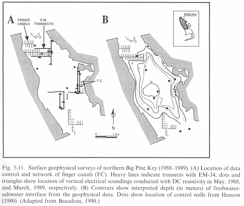
Wightman (1990) went on to model the interface in a two-layer island shaped like Big Pine Key in order to assess the variation in freshwater residence time within the Key. The model was a steady-state, finite-difference DGH model like that of Fetter (1972) and used the values of R, K1, and K2 from the circle fit. The results for the depth to the interface are shown in Fig. 5-10. The interface contours were used to define streamlines (in map view; Fig. 5-10A) that divide the lens into curving wedges extending downward to the interface. These wedges were divided into streamtubes (in vertical section; Fig. 5-10C) by apportioning the discharge along vertical intercepts, while taking into account the changing widths and different hydraulic conductivities (Vacher et al., 1992). Incremental travel times along the streamlines then were calculated and summed to give the residence time of a parcel of water that entered at particular points as seen on the map. The result (Fig. 5-10B) shows how long (in years) it takes a parcel of water to flow out of the lens after entering at the water table in the interior of the island. The residence time of individual parcels varies up to 8 years. The streamtube construction also calls attention to the funneling of discharge through the upper part of the buried K2 layer (Vacher et al., 1992). While Wightman (1990) mapped the regional configuration of the lens in Big Pine Key, Beaudoin (1990), using the same surface-geophysical instruments, focused on the periphery. The specific object of Beaudoin's study was on the finger canals, which are a common feature in the Keys. The purpose of the canals is to provide boat access for residences inland of the shoreline. According to Beaudoin (1990), approximately 10.5 km of canals are dredged to depths of 2.5-6 m into Big Pine Key. Most of the canals are in the northern half of the island. The effect on the lens is clearly shown in Fig. 5-11: the canals act as a lateral boundary for the lens and focus the discharge there.
|
|||||||||||||||||||||||||||||||
U.S. Department of the Interior, U.S. Geological Survey
This page is: http://sofia.usgs.gov/publications/papers/keys_geohydro/hydrogeology.html
Comments and suggestions? Contact: Heather Henkel - Webmaster
Last updated: 21 January, 2005 @ 10:44 AM (KP)