| 1650 |  |
A map of Hudson Canyon reproduced in James Dwight Dana's Manual of Geology, first edition, published in 1862. This map was provided by the United States Coast Survey to Dana. The first discovery of submarine canyons occurred on the Pacific Coast, Hueneme Canyon in 1855 and Monterey Canyon in 1857. |
|
1651 |  |
A curious map of the Arctic Ocean showing land extending north from Greenland. Published in 1869 in Petermann's Geographische Mittheilungen. |
|
1652 |  |
Josephine Bank, the first seamount discovered as a direct result of intentional exploration. Discovered by the Swedish Corvette Josephine in 1869. Northern 9/10 of bank. |
|
1653 |  |
Josephine Bank, the first seamount discovered as a direct result of intentional exploration. Discovered by the Swedish Corvette Josephine in 1869. Southern 1/2 of bank. |
|
1654 |  |
Josephine Bank, the first seamount discovered as a direct result of intentional exploration. Discovered by the Swedish Corvette Josephine in 1869. Image digitally merged from images map00016 and map00017. |
|
1655 |  |
The east coast of the United States showing the continental shelf, shelf break, continental slope, and sediment types. This was one of the first published maps of this nature. The Coast Survey had rediscovered the continental shelf break in 1848. Count Luigi Marsili had first noted it in the Gulf of Lyon about 1720 but that information had been forgotten in the mid Nineteenth Century. |
|
1656 |  |
"The Sea Bottom off Florida and Cuba" as published by Petermann's Geographische Mittheilungen in 1870. This map was drawn by Louis Francois de Pourtales of the the United States Coast Survey. Pourtales Plateau was named by Louis Agassiz, the first undersea feature off the continental shelf in U.S. waters that was discovered as the result of oceanographic exploration. |
|
1657 |  |
"The Sea Bottom off Long Island" as published by Petermann's Geographische Mittheilungen in 1870. This map was drawn by Louis Francois de Pourtales of the the United States Coast Survey. Map shows head of Hudson Canyon, the canyon axis as shown by the Mud Holes as it crosses the continental shelf, and the sediment types. |
|
1658 | 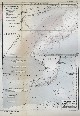 |
Full page presentation of the two maps shown in image map00019 and map00020. as published by Petermann's Geographische Mittheilungen in 1870 by Louis Francois de Pourtales of the United States Coast Survey. |
|
1659 |  |
Map of the North Atlantic Ocean published on the eve of the CHALLENGER Expedition in "The ocean, atmosphere, and life...." by the French geographer Elisee Reclus. This map shows some very large non-existent shoals to the east of Newfoundland as well a deep extending to the NE which seems imaginative. The profile is based on the work of Dayman and Berryman in 1856/1857. |
|
1660 |  |
Map of the Atlantic Ocean published after the outward bound segment of the CHALLENGER Expedition. This map shows little improvement over earlier versions. The Mid-Atlantic Ridge is shown bending to the west south of the Azores and there is no expression of the ridge in the South Atlantic Ocean. |
|
1661 |  |
Map of the area southeast of New Guinea showing various reefs and islands in a sparsely surveyed area. In: Petermann's Geographische Mittheilungen for 1874. |
|
1662 |  |
Map of the Congo Canyon, one of the great canyons on the west coast of Africa. The source is noted as "Medlycott and Flood", 1875. Medlycott is mentioned by as having been associated with HMS LYNX in 1859 on the west coast of Africa, so this would place the discovery of Congo Canyon sometime between 1859 and 1875. |
|
1663 |  |
The "Contour Map of the Atlantic" should be known as one of the classical maps of the Earth Sciences. This version of the map was published by Sir Wyville Thomson of the CHALLENGER Expedition in 1877 and is the first ever to show the continuity of the Mid-Atlantic Ridge. The N-S line in the south Atlantic followed the ridge and is among the most important survey lines ever run. |
|
1664 |  |
This map, by Augustus Petermann, was the first bathymetric map of the Pacific Ocean. Data was acquired by the CHALLENGER, the USS TUSCARORA, and the German research ship GAZELLE. Note the much denser sounding information on the TUSCARORA as the result of first use of piano-wire sounding. Note the Tuscarora Deep, first discovery of a trench, today called the Japan-Kuril Trench. |
Pacific Ocean North 1877 |
1665 |  |
Soundings taken by the first USS ENTERPRISE exploration vessel under the command of Captain Albert S. Barker. This was the first U.S. ship to specifically circumnavigate the globe on a sounding and temperature measuring expedition. Note the shoal area at approximately 29 N 34 W. This was originally called the Barker Rise but is now called the Rio Grande Rise. |
Atlantic Ocean South 1883-1886 |
1666 |  |
Track of the USS ENTERPRISE across the Indian Ocean. Note the 3097 fathom sounding southwest of Sumatra. That sounding is the first indication of the Java Trench. A few years later, Sir John Murray named that area the Enterprise Deep, a name which has been superceded by Java Trench. |
Indian Ocean 1883 |
1667 |  |
Track of the USS ENTERPRISE across the southern Pacific Ocean in 1885. At the time this line was run, it was the furthest south continuous east-west sounding line yet observed. |
Pacific Ocean South 1885 |
1668 |  |
Profiles of Concepcion Bank and Seine Bank by Edward Stallibrass, a British telegraph engineer, as published in 1887 in "Deep-Sea Sounding in Connection with Submarine Telegraphy," Journal of the Society of Telegraph-Engineers and Electricians, Volume XVI, No. 68, pp. 478-521. |
|
1669 |  |
Maps of the track of the DACIA in 1883, the Bottomless Pit, and Congo Canyon, by Edward Stallibrass, a British telegraph engineer, as published in 1887 in "Deep-Sea Sounding in Connection with Submarine Telegraphy," Journal of the Society of Telegraph-Engineers and Electricians, Volume XVI, No. 68, pp. 478-521. |
|
1670 |  |
Map of the Congo Canyon as surveyed by the Cable Ship BUCCANEER, by Edward Stallibrass, a British telegraph engineer, as published in 1887 in "Deep-Sea Sounding in Connection with Submarine Telegraphy," Journal of the Society of Telegraph-Engineers and Electricians, Volume XVI, No. 68, pp. 478-521. |
|
1671 |  |
Map of the "Bottomless Pit" (a canyon) as surveyed by the Cable Ship BUCCANEER, by Edward Stallibrass, a British telegraph engineer, as published in 1887 in "Deep-Sea Sounding in Connection with Submarine Telegraphy," Journal of the Society of Telegraph-Engineers and Electricians, Volume XVI, No. 68, pp. 478-521. |
|
1672 | 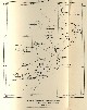 |
Map of the track of the Cable Ship DACIA in 1883, showing Concepcion, Dacia, Seine, Josephine, and Gettysburg Banks, and Coral Patch, by Edward Stallibrass in "Deep-Sea Sounding in Connection with Submarine Telegraphy," Journal of the Society of Telegraph-Engineers and Electricians, Volume XVI, No. 68, pp. 478-521. |
|
1673 |  |
World map with ocean physiography published in 1887 in Appletons' American Standard Geographies Physical Geography , pp. 20-21. Note "Alaska Deep" and "Alaska Rise" off the coast of South America. These were discovered by George Belknap on the USS Alaska in 1882 and were the first published names for the Peru-Chile Trench and Chile Rise. |
|
1674 |  |
Atlantic Ocean as shown by John D. Quackenbos and William Healy Dall in: Appletons' American Standard Geographies Physical Geography , pp. 20-21. The Dolphin Rise was named for the USS DOLPHIN which first sounded on the Mid-Atlantic Ridge under Lieutenant Commanding Otway Berryman in 1853. |
|
1675 | 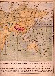 |
Indian Ocean and western Pacific Ocean as shown by John D. Quackenbos and William Healy Dall in: Appletons' American Standard Geographies Physical Geography , pp. 20-21. Note that Ninety East Ridge is missing and that the deepest depth yet observed up to 1887 was the TUSCARORA Deep in what we now call the Kuril Trench to the NE of Japan. |
|
1676 |  |
Sir John Murray's map of the Atlantic Ocean, Chart 1A, accompanying the Summary of Results of the Challenger Expedition, 1895. |
Atlantic Ocean |
1677 |  |
Sir John Murray's map of the Indian Ocean, Chart 1C, accompanying the Summary of Results of the Challenger Expedition, 1895. |
Indian Ocean |
1678 |  |
Sir John Murray's map of the Pacific Ocean, Chart 1B, accompanying the Summary of Results of the Challenger Expedition, 1895. |
Pacific Ocean |
1679 |  |
Section of North Pacific Ocean on Murray's map of the Pacific Ocean, Chart 1B, accompanying the Summary of Results of the Challenger Expedition, 1895. |
|
1680 |  |
Title page to George Davidson's "The Submerged Valleys of the Coast of California....", in Proceedings of the California Academy of Sciences, Third Series, Vol.1, No. 2. This paper documented Coast Survey discoveries of submarine canyons beginning with the first ever discovered, Hueneme Canyon, in 1855. Monterey Canyon was the second, discovered in 1857. |
|
1681 |  |
A map by Adolph Lindenkohl of the United States Coast and Geodetic Survey showing the specific gravity of the waters of the North Pacific Ocean. Published in Petermann's Geographische Mittheilungen in 1897. |
|
1682 |  |
Sir John Murray's world map of 1899, Atlantic Ocean. The only physiographic feature he named were deeps, defined as area of the seafloor believed to have depths greater than 3000 fathoms. |
|
1683 | 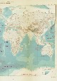 |
Sir John Murray's world map of 1899, Indian Ocean. The only physiographic feature he named were deeps, defined as area of the seafloor believed to have depths greater than 3000 fathoms. |
|
1684 |  |
Sir John Murray's world map of 1899, Pacific Ocean. The only physiographic feature he named were deeps, defined as area of the seafloor believed to have depths greater than 3000 fathoms. |
|
1685 |  |
Alexander Supan's world map of 1899 showing both deeps and bathymetric highs of the World Ocean. Note difference in names between Supan and Murray in previous map. Supan's naming methodology prevailed in the Twentieth Century. Note also the Karolinen Graben running parallel to the Caroline Islands as opposed to the correct orientation of the Mariana Trench. |
|
1686 |  |
Alexander Supan was among the first to recognize the nature of oceanic trenches. Compare his nomenclature for the Aleutian Trench to John Murray's 1899 map. Perhaps Supan Deep as shown by Murray was a little jab as Murray continued this sort of terminology until his untimely death in 1914. |
|
1687 |  |
A Russian map of the Barents Sea by L. Brietfuss and A. Smirnow published in 1905. Additions to soundings based on the expeditions of Willem Barentz and Karl Weyprecht. |
|
1688 |  |
A Russian map of the Barents Sea by L. Brietfuss and A. Smirnow published in 1905. Same map as the last. |
|
1689 |  |
Otto Krummel's map of the Mariana Trench. In: "Handbuch der Ozeanographie", 1907. This corrects the error made by Supan in his 1899 map which showed a Karolinen Trench running parallel to the north side of the Caroline Islands. |
|
1690 |  |
A map of Germany's western Pacific colonies as of 1910. The Mariana Trench and Tonga-Kermadec Trenches are shown clearly as are a few seamounts. The deepest spot on this map is now in the Mariana Trench, SE of Guam, with a depth of 9636 meters. The deepest point in the Mariana Trench is now know to be approximately 10,915 meters. |
|
1691 |  |
A 1912 map of the World Ocean by Sir John Murray. He published one more map prior to his death which still retained his use of personal names for major features of the world ocean and did not acknowledge the configuration of most trenches. |
|
1692 |  |
A 1912 map of the Atlantic Ocean by the German oceanographer Gerhard Schott. Note the use of the term Telegraph Plateau following the 1858 nomenclature of Maury. In: "Geographie des Atlantischen ozeans" by Gerhard Schott. Library Call No. GC481 .S34 1. Aufl. (1912) . |
|
1693 |  |
A 1912 map of the Atlantic Ocean by Max Groll. Although quite similar to Gerhard Schott's map, it is totally devoid of feature names. The number of included soundings, although providing evidence for the determination of contour lines, tends to obscure the overall pattern of seafloor features. |
|
1694 |  |
The northern half of the 1912 Atlantic Ocean map by Max Groll. In: Tiefenkarten der Ozeane mit Erlauterungen. Plate I, Atlantic Ocean. |
|
1695 |  |
A 1912 map of the Indian Ocean in Tiefenkarten der Ozeane mit Erlauterungen by Max Groll. Note the light-colored (shallower) area between Australia and Antarctica, an early indication of the continuity of the oceanic ridge system in the South Indian and South Pacific Oceans. Amazingly, a feature as large as Ninety East Ridge had yet to be discovered. Plate II, Indian Ocean. |
|
1696 |  |
A 1912 map of the Pacific Ocean in Tiefenkarten der Ozeane mit Erlauterungen by Max Groll. Note the light-colored (shallower) area in the vicinity of what is today called the East Pacific Rise, and early indication of the continuity of the oceanic ridge system. Plate III, Pacific Ocean. |
|
1697 |  |
Sir John Murray's map of the world ocean published in 1912. Murray stuck with his nomenclature and interpretation of features until his death. The German geographers were definitely ahead of the world in their understanding of the nature of the seafloor and our planet until the Second World War. |
|
1698 |  |
Sir John Murray's continuation of the naming of features for researchers even though they never worked in a given area. Supan had understood the nature of the Aleutian Trench and named it accordingly in 1899. Murray refused to acknowledge either the interpretation or the naming system proposed by Supan which has since been adopted by the world with minor modifications. |
|
1699 |  |
Gerhard Schott's 1912 map of the Arctic Basin and North Atlantic showing numerous distinct basins and, although first soundings on Reykjanes Ridge was probably on H.M.S. BULLDOG in 1860, this is among the first maps to show it as a named feature. In: Geographie des Atlantischen Ozeans by Gerhard Schott, 1912. P. 120. |
|

