|
|
iMAP
News |
Step back in time with iMAP's 1936 aerial photos!
June 23, 2008
 The King County GIS Center and the Department of Transportation - Roads Services are pleased to announce the addition of 1936 aerial photos to iMAP. These black and white aerial photos cover almost all of western King County within the Urban Growth Boundary, including Mercer Island and Vashon Island. The King County GIS Center and the Department of Transportation - Roads Services are pleased to announce the addition of 1936 aerial photos to iMAP. These black and white aerial photos cover almost all of western King County within the Urban Growth Boundary, including Mercer Island and Vashon Island.
Information on how these aerial photos came about can be found in this essay on historylink.org.
|
 The Survey has ended; thanks to all who responded! The Survey has ended; thanks to all who responded!
July 7, 2008
Our online mapping applications, iMAP and Parcel Viewer, meet a broad range of user needs. First-time or occasional users might look up information about one particular piece of property. Others have come to rely on these tools as part of their day-to-day business.
We'll incorporate the results of the survey as we make iMAP and Parcel Viewer easy to use for a wide and diverse audience, and to make the user experience more and more productive.
And in the meantime, the prize drawing will be held on July 11th. |
New parcel label option: house number labels
October 24, 2007
iMAP users now have the option to label parcels with the house number as well as the parcel number. We've received requests from iMAP users who wanted to be able to create maps that show house numbers instead of parcel numbers, and we've responded by making that option available to you. You can choose to label parcels with house numbers, parcel numbers, or both!
If you have a suggestion that will make iMAP better serve the needs of users, send it to us at giscenter@kingcounty.gov

|
New iMAP Map Set: Electoral Districts
October 24, 2007
The addition of a new map set, "Electoral Districts", brings the number of distinct sets of map layers that can be viewed in iMAP to eleven . This new map set provides district boundary information for King County, including voting precincts, King County Council, Legislative, Congressional and minor taxing district boundaries.
The district data layers in this map set are maintained by King County Records, Elections and Licensing Services Division and reflect district boundaries eligible for election. They do not include such service area boundaries as water or sewer service agency's service areas.
As with all iMAP map sets, the same iMAP interface and base map layers as well as a property search function are included along with this new collection of map layers.
More:
iMAP Electoral Districts: description, data layers, iMAP start button
Find Your Council District
King County Records and Elections
|
A Big Step Up for iMAP Printing
April 2, 2007
Map print layouts
in iMAP are now created in Adobe Acrobat
PDF format, which makes viewing, saving,
printing and sharing your map layouts easier
than ever. Zoom, pan, save, print and more
with all of the controls in Adobe's
Acrobat Reader. There's a good chance you
already have Acrobat Reader on your computer.
If not, download it free from the Adobe
website.
You can
still choose a landscape or
portrait orientation on any of three page
sizes for your map layout. But printing your
layouts is much easier since you no longer
have to reset your browser to the orientation
and size of your layout to get the correct
print output—Acrobat automatically
fits your map layout to your selected page
dimensions.
Have you had trouble
with lengthy map legends when printing from
iMAP? Trouble no more—a second print
page is automatically created if necessary
to handle the map legend.
Give iMAP printing
a try. Just click the same familiar iMAP
print button to start a new custom map layout.
See
How:
|
iMAP News Archive |
2005 Aerial
Photos Now in iMAP
March 12, 2007
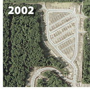 The
King County GIS Center is pleased to announce
the addition of 2005 color aerial photos,
at one-foot-per-pixel resolution, to all
iMAP map sets. The
new photos, acquired last year from Aerials
Express, represent
the first wide-scale aerial imagery update
for King County since 2002. Because the local
geography can change so rapidly, as shown
in the accompanying illustration
(hover your mouse cursor over the image to
compare photos),
the King County GIS Center has now budgeted
funds to acquire new aerial photo imagery
every two years. Our plan calls for the next
set of photography to be taken in the summer
of this year, with processing (for image
quality and ortho-rectification, i.e., the
removal of optical, height, and angle-of-view
distortions) anticipated during the fall.
iMAP users can look forward to seeing the
new aerial imagery early in 2008. The
King County GIS Center is pleased to announce
the addition of 2005 color aerial photos,
at one-foot-per-pixel resolution, to all
iMAP map sets. The
new photos, acquired last year from Aerials
Express, represent
the first wide-scale aerial imagery update
for King County since 2002. Because the local
geography can change so rapidly, as shown
in the accompanying illustration
(hover your mouse cursor over the image to
compare photos),
the King County GIS Center has now budgeted
funds to acquire new aerial photo imagery
every two years. Our plan calls for the next
set of photography to be taken in the summer
of this year, with processing (for image
quality and ortho-rectification, i.e., the
removal of optical, height, and angle-of-view
distortions) anticipated during the fall.
iMAP users can look forward to seeing the
new aerial imagery early in 2008.
More:
|
Easier iMAP Property Searches
March 12, 2007
We've made
two improvements to iMAP's property search
function that regular users will especially
like. First, we've done away with
the old address search form that required
you to enter the house number in one box
and the street name in a separate box. Now
you can quickly and easily type
an address on one line. The address
search will still show you a list of candidates
if there isn't an exact match for what you
enter. This means that if you wish, you can
generalize your search by using partial street
names, house numbers with no street names,
and even street names with no house number.
The less specific your input, the more results
you can expect.
The second improvement
is for condominium searches. Because an entire
condominium complex is represented by only
one address in our property database, it
can be a challenge to find a condo complex
using the address search function when buildings
or units within a complex have different
addresses from one another. But now you can search
by condominium complex name—just
enter all or part of the name and you'll
get a list of matches from which to choose. |
New
Map Set: Shoreline Master Program
January 18, 2007
The addition of
a new map set, "Shoreline
Master Program," brings to ten the
number of distinct sets of map layers that
can be viewed in iMAP.
The availability of this new map set coincides
with the launch of a website that
provides citizens a wide range
of information about the update to King County's Shoreline
Master Program, which is now underway.
The Shoreline Master
Program is a set of policies and regulations
that determine how major shorelines in unincorporated
King County are managed. The program dates
back to 1978 and has not been changed significantly
since then. King County is now updating the
program as required by the Washington State
Shoreline Management Act, which was approved
by public referendum in 1972. The program
update will address the effects of nearly
30 years of development and population growth
(more than half a million people).
The Shoreline Master
Program map set in iMAP is just one of many
new resources and tools that citizens can
use to learn about the broad policy goals
and the specific details of shoreline management
in King County.
More:
|
iMAP
Makeover: Easier to Read Maps, Coordinate
Mapping, Smart Links
October 20, 2006
Map Redesign
The
King County GIS Center is happy to announce
the release of new map symbolization for
iMAP. When we have asked users what
we could do to make iMAP better they suggested
changes in the way many of the map features
are symbolized. We listened and got to work
making easier to read maps that will better
help you find the information you are seeking.
Among the many
improvements, elevation contour lines can
now be displayed in a light or a dark color
so that you can choose the one that looks
best for your purposes.
Also, street
lines are easier to see, parcel boundary
lines are more distinct, city names are more
legible, city boundaries are clearer and
the cities layer ("Incorporated Area")
no longer interferes with viewing aerial
photos.
We hope you like
these changes and find it even easier to
use iMAP because of them.
| |
 |
|
 |
|
 |
| |
iMAP sample map images: click
to view full-size |
Map
Your Own Coordinates
The latest new
iMAP function lets you
enter a pair of geographic coordinates for
any point that lies within King County and
automatically zoom to that point. Many users
are already familiar with iMAP's "Capture
Coordinates" tool with which one can
obtain the geographic coordinates for any
point in the iMAP display. Now the tool is
called simply "Coordinates,"
and in addition to its original
function, you can use it to enter any pair
of coordinates you choose and map that location.
The tool will accept both latitude/longitude
and state plane coordinates. Latitude/longitude
coordinates are derived typically from Global
Positioning System (GPS) devices and mapping
programs, such as Google Earth. State plane
coordinates are used by surveyors, mapmakers,
and GIS users. (For information about the
state plane coordinate system, see "What
is the Standard Projection for King County
GIS Data" in the KCGIS Knowledge Base.)
This new feature
is another response to requests made by iMAP
users during our user survey last summer
and through e-mail inquiries to us. If you
have a question or suggestion about iMAP,
please e-mail
us. Maybe your suggestion will appear
in a future version of iMAP.

Coordinates entry form sample image: click to view full size
Make
Your Own Smart Links
Have you ever wanted
to send someone a hyperlink that will take
them right to the same iMAP view you are
seeing—maybe
even with a particular parcel selected? Well
now you can! Although there is no automatic
way to create such a link, with a little
planning, you can construct a URL to iMAP
that will:
- open a particular
map set
- select a specific
parcel
- center on a chosen
latitude/longitude or state plane coordinate
- zoom to a set scale.
If
you are interested in learning how to do
this, just consult the new iMAP
FAQs entry for complete instructions.
|
Measure More with New iMAP Measure Tool Features
August 31, 2006
When
surveyed recently, many iMAP users
requested the ability to perform area measurements.
We're happy to now offer this feature, as
well as the new ability to see the length
of each line segment drawn by the measure
tool right on the map. Another requested
change was in the default map units, which
is now set to feet. You can switch easily
to different units for both distance and
area with the Set Units button.
Give
the upgraded measure tool a try, and
let us know what you think  . .

Example
of the iMAP Measure Tool results.
|
New Data
Layers for iMAP's Sensitive Areas Map Set
July 18, 2006
 We've recently
expanded the list of data layers that can
be viewed in iMap's Sensitive
Areas map set with seven layers related
to the Critical Areas Ordinance (CAO). King
County passed the Critical Areas Ordinance
in January 2005 to protect public health
and safety, as well as public and private
resources, from natural hazards by limiting
development in hazard areas, such as steep
slopes or flood zones.
The CAO is also intended to protect environmentally
sensitive areas, such as wetlands and streams,
from being adversely affected by clearing
and development of land for residences, commercial
use and livestock. We've recently
expanded the list of data layers that can
be viewed in iMap's Sensitive
Areas map set with seven layers related
to the Critical Areas Ordinance (CAO). King
County passed the Critical Areas Ordinance
in January 2005 to protect public health
and safety, as well as public and private
resources, from natural hazards by limiting
development in hazard areas, such as steep
slopes or flood zones.
The CAO is also intended to protect environmentally
sensitive areas, such as wetlands and streams,
from being adversely affected by clearing
and development of land for residences, commercial
use and livestock.
The
inclusion of the CAO layers in the Sensitive
Areas map set can help users determine the
presence of CAO-related factors that may
affect permitting on particular parcels.
However, proposed projects should be discussed
with the Permit Center staff in the King
County Department of Development and Environmental
Services (DDES) at 206-296-6600.
More |
|
New iMAP Custom Print Options
March 31, 2006
The variety of custom maps you can print in iMAP just increased dramatically with the ability to choose from three page sizes and two page orientations. Formerly iMAP offered only letter-size map prints in a portrait orientation. Now you can print your own maps in standard letter (8.5x11-inch), legal (8.5x14-inch) and tabloid (11x17-inch) sizes, and you can choose a portrait or landscape page orientation for any of the three sizes. These six page layout options combined with iMAP's other map customizing functions, such as the ability to choose which layers to display, to highlight features on the map, and even to draw your own points, lines, polygons and text, make it possible to create truly individual and unique maps tailored to your specific needs.
The King County GIS Center is dedicated to making iMAP an ever more useful tool for you to find the information you need and get your work done. Your input is important to us and this update to the iMAP print function is in direct response to requests from iMAP users.
Please contact us if you find a problem, have a question or idea for us, or just to let us know what you think of our efforts.
Check it out! Start iMAP
|
|
iMAP Changes: Improved Layer List, Additional Map Layers, User-Controlled Markup Tools
December 19, 2005
In our ongoing effort to make iMAP more useful and user friendly, we have made another round of improvements which include improved layer control, additional map layers, and a new tool for adding your own text, points and lines to the map.
Improved Layer Control
The most visible and important change introduced in this revision is the "Layer List" on the right side of the iMAP display. No longer one long list, the new layer list organizes layers into thematic groups. These groups can be expanded and collapsed so you can better control what you are seeing. All map layers will be listed, all the time. Instead of layers getting removed from the list for which the map is at a scale that the layer cannot be drawn, the layers will change font style and color to indicate that they can't be drawn at the current scale. Some layers will now include this small icon beside the name:  . Hover your mouse on the icon to see additional information, or click to open another page with more information about that layer or the subject area that layer represents. . Hover your mouse on the icon to see additional information, or click to open another page with more information about that layer or the subject area that layer represents.
We now give you an "auto-refresh" option which will update the map each time you turn a layer on or off, without having to click on the "Refresh Map" button.
Finally, a tabbed control at the top of the layer list lets you quickly tab between the layer list and the map legend without having to go over to the tool bar on the left side of the iMAP display.
Additional map layers
We've added new or updated layers to the iMAP map sets, including Zip codes, County Council Districts, PLSS townships and sections, Thomas Guide page and row/column indexes, and the Kroll map book index. To the Property Information map set we've added a layer to show properties known to have been used for Illegal Drug Labs.
Add text and graphics to your map
We've added a new tool to the toolbar that will let you add text and simple graphics to your map. Now you can annotate your maps with comments or pointers, or highlight an area or feature of interest before you save or print the map image.
Map set retired
The "Points of Interest" map
set has been retired. Some of the Points
of Interest layers have been moved into the "Property
Information" map set, where they will
be more useful.
|
|
New
iMAP Layers: Improved Elevation Contours, Mountain Peaks
September 30, 2005
Improved
elevation contour lines are now available in most iMAP
map sets. If you have ever looked at contour lines with
iMAP, you will immediately notice the dramatic increase
in quality that these lines represent. If you have never
used contour lines with iMAP, you may not have been able
to find them as they were in only four of the twelve iMAP
map sets. The new contour lines, which cover all of King
County, are now included in most map sets, including the
widely used 'Property Information'
map set (the default map set unless you choose otherwise).
Our new
contour lines are available in 5-foot and 100-foot intervals.
These are scale-dependent, so you will not see them listed
as an available layer until you have zoomed in to a scale
of 1:63,360 (one inch to one mile) for the 100-foot intervals
and 1:12,000 for the 5-foot intervals.
These contour
lines were created from our 6-foot* lidar digital elevation model (DEM), and replace the older, less
accurate contours which were from a 10-meter DEM.
A mountain
peaks data layer has also been added to complement the elevation
contours. This layer shows the name of major peaks in King
County and works very well when combined with contour lines,
shaded relief, or aerial photos.
*The
6-foot dimension represents the smallest resolvable detail
in the original lidar data capture.
More: Elevation Contours Metadata
Mountain
Peaks Metadata
|
|
Easier
Access to Online Mapping
June 13, 2005
New, shorter,
easier-to-remember and easier-to-type web addresses now
simplify access to Parcel Viewer and iMAP. Anyone who does
not already have the launch pages for the applications bookmarked
(you're on the iMAP launch page) now needs to remember only
the application names themselves. And it's easier and quicker
to type the new address if you want to send them to a friend
or colleague. All you need is the address for the KCGIS
website: www.metrokc.gov/gis, followed by the name of the
application.
Parcel
Viewer is www.metrokc.gov/gis/ParcelViewer
iMAP
is www.metrokc.gov/gis/iMAP
Return users
will be happy to know that their current bookmarks to these
application launch pages are still valid.
|
|
Map
Set Retired: WRIA 8 Action Agenda
April 18, 2005
Due to various
technical and use-related issues, the "WRIA 8 Action
Agenda" map set has been removed indefinitely from
iMAP. |
|
Condominium Unit Descriptions Available
Currently, iMAP will only find the
condo complex Parcel Number (ending in '0000'), but will
soon be updated to accept the condo Unit Parcel Number as
well. If you have a condo unit Parcel Number or Tax Account
Number, you can use the first 6 digits of that number and
add the 0000 for a 10 digit condo complex Parcel Number.
This will get you zoomed to the parcel with a link to the
Property Report for the complex and all the individual units. |
|
Pop-Up
Blockers
Many
of us employ pop-up blockers to bypass annoying and unwanted
advertisements. But did you know that if you are running
a pop-up blocker you might prevent iMAP from opening? iMAP
launches in a new browser window, a necessary function which
could nevertheless be prevented by a pop-up blocker installed
in your computer or browser. If you click on a link to launch
iMAP and nothing happens, there is a good chance a pop-up
blocker is preventing iMAP from launching.
We cannot test all pop-up blockers
to determine your options, but most give you the ability
to choose sites that you trust so that pop-ups and new browser
windows are allowed for those sites only. Some let you override
the blocking function on a temporary basis. For example,
the Google toolbar pop-up blocker prevents iMAP from launching,
but if you hold down the CTRL key while you click the iMAP
link, iMAP (in its new window) is allowed to launch. |
|
Revised
August 12, 2008
|
|
|


