 |
 | |
  | |
|
|
|
|
Pictured Rocks National Lakeshore
Scenic Sites
|
|
|
|
|
| |
 |
Many areas within Pictured Rocks National Lakeshore are easily accessible by vehicle or short hiking trails. While enjoying these scenic sites, take time to enjoy the forests, wildlife, and lakes too.
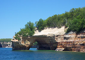 |
| NPS photo by Brenda St. Martin | | Petit Portal |
 |
Pictured Rocks
The Pictured Rocks stretch for about 15 miles along Lake Superior from Sand Point on the west to just after Spray Falls on the east.
Colorful and bold, the Pictured Rocks tower 50 to 200 feet directly from Lake Superior. The name "Pictured Rocks" comes from the streaks of mineral stain that decorate the face of the weather-sculpted cliffs. Sandstone cliffs of ochre, tan, and brown - sandwiched with layers of white, green, orange, and black - glisten against the cloud-streaked sky and clear waters of Lake Superior.
Miners Castle provides a wonderful vista of the Pictured Rocks cliffs. At Sand Point, the cliffs are off in the distance.
The extends the length of the lakeshore, providing beautiful views along the trail for both backpackers and day hikers. For safety's safe - please stay away from the cliff edge!
operate from Munising from late May to mid October for a water view of the Pictured Rocks.
|
 |
| NPS photo by Brenda St. Martin | | Sand Point Beach |
 |
Sand Point
Located about four miles northeast of Munising, at the end of Sand Point Road.
The Sand Point beach is a popular spot for walking in the evening to watch the sun go down over Munising Bay. Beach enthusiasts enjoy the long expanse of Lake Superior shore, though the water is often too cold for even the hardiest swimmers.
The , a half-mile disabled accessible interpretive trail, features a large print brochure for visually impaired visitors. Sand Point is a good place to look for warblers in spring and fall.
Nearby at former Munising U.S. Coast Guard Station, a 36-foot self-righting motor lifeboat is on display in the boathouse from May through October. Park headquarters is also located on Sand Point.
|
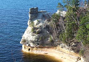 |
| NPS photo by Brenda St. Martin | | Miners Castle |
 |
Miners Castle
Located about 6.5 miles east of Munising on Alger County Road H-58, then five miles north on Miners Castle Road.
Miners Castle is the most famous formation of the Pictured Rocks, and is accessible by vehicle and short trails.
Beginning at the picnic area, a paved foot trail leads past interpretive exhibits to breathtaking overlooks of Lake Superior and Grand Island. Stairs and a steeper trail lead to the lower overlook adjacent to Miners Castle. Miners Castle site bulletin (pdf)
Erosion over long periods of time has created the interesting rock formations that give this place its name. A dramatically changed the look of Miners Castle.
|
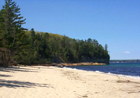 |
| NPS photo by Ed Lasich | | Miners Beach |
 |
Miners Beach and River
Located about 6.5 miles east of Munising on Alger County Road H-58, then six miles north on Miners Castle Road.
A picnicker and beach walker's delight, Miners Beach stretches for one mile along Lake Superior where waves roll in to polish beach cobbles. Miners River is popular for steelhead fishing in spring and fall.
Whenever at a beach, be aware of , powerful currents of water moving away from shore. They can sweep even the strongest swimmer out to sea.
|
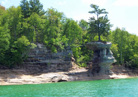 |
| NPS photo by Gregg Bruff | | Chapel Rock and Beach |
 |
Chapel Rock and Beach
Located about 15 miles east of Munising off Alger County Road H-58, then about 5 miles north to the end of Chapel Road (drive), then 2.5 miles (hike) to Lake Superior.
Trails to the beach overlook Chapel Lake with views of the beautiful Chapel Falls on the west side.
The Chapel area was named by early European explorers and is found on early maps as La Chappelle. Chapel Rock is a remnant of Cambrian age sandstone. The archway between the rock and the mainland collapsed in the 1940's. It and the remaining arch were carved by Lake Nipissing high waters some 3800 years ago.
Chapel Beach is also a remnant of Lake Nipissing, blocking Chapel Creek to form Chapel Lake. The area invites hikers and boaters to linger, and a popular backcountry campsite is found here.
|
 |
| NPS photo by Gregg Bruff | | Twelvemile Beach |
 |
Twelvemile Beach
Located along the Lake Superior shoreline; access at the Twelvemile Beach Campground, about 16 miles west of Grand Marais on Alger County Road H-58.
The Pictured Rocks cliffs give way to this isolated beach strand shortly after Spray Falls. The beach continues until the Grand Sable Banks rise high above Lake Superior near Grand Marais. Twelvemile Beach is a wonderful place for long walks along the shore.
|
 |
| NPS photo by Ed Lasich | | White Birch Forest |
 |
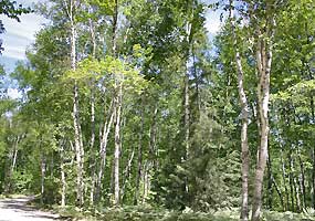
White Birch Forest
Located along the entrance road to , about 16 miles west of Grand Marais on Alger County Road H-58.
This picturesque stand of white birch welcomes visitors to Twelvemile Beach and Lake Superior, and features the 2-mile self-guiding White Birch Nature Trail.
|
 |
| NPS photo by Ed Lasich | | View to the east from the Log Slide |
 |
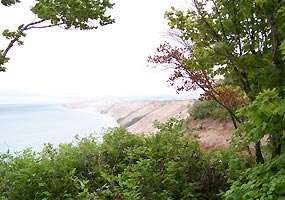
Log Slide
Located about 7 miles west of Grand Marais on Alger County Road H-58, then almost 1 mile north on Log Slide Road.
Legend has it that logs sent down the dry log chute would generate enough friction to cause the chute to catch fire. Today the chute is gone, but the lumberjack stories still linger as you gaze out over the Grand Sable Banks and Dunes. This is a good place to glimpse the Au Sable Light Station to the west and the Grand Sable Banks and Grand Marais to the east.
|
 |
| NPS photo by Gregg Bruff | | Grand Sable Banks and Dunes |
 |
Grand Sable Banks and Dunes
Located about one mile west Grand Marais; the best place to view is from the trail beginning at the Sable Falls parking area.
Another access point for the dunes is from the , one-quarter mile east of the Log Slide. Please stay on the trail as the dunes vegetation is fragile.
Five square miles of Grand Sable Dunes are perched atop the 300-foot high Grand Sable Banks. Left by enormous glaciers, the Grand Sable Dunes dwarf comprehension.
A portion of the Grand Sable Dunes is set aside as a Research Natural Area. Grand Sable Dunes RNA site bulletin (pdf)
|
|  |  |
|
|

Interagency Visitor Center
Please make the IVC your first stop.
more... | | 
Poison ivy
is found at several places within the lakeshore.
more... | | 
Grand Sable Visitor Center
Stop by when you are in Grand Marais
more... | | 
Rip currents
powerful currents of water moving away from shore.
more... | |
|
|
|
|
|
|
|
 |
|
Did You Know?
Located within Pictured Rocks National Lakeshore, the Au Sable Light Station is on the National Register of Historic Places. Constructed in 1874, the station beacon still shines over Lake Superior's frigid waters. The lamp is now solar powered.
more...
|
|
|
|
Last Updated: March 25, 2008 at 12:04 EST |


