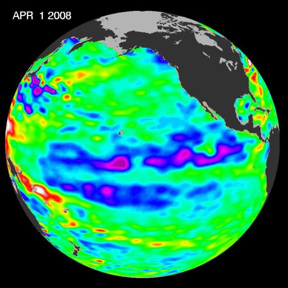
Boosted by the influence of a larger climate event in the Pacific, one of
the strongest La Niñas in many years is slowly weakening but continues to
blanket the Pacific Ocean near the equator, as shown by new sea-level
height data collected by the U.S.-French Jason oceanographic satellite.
This La Niña, which has persisted for the past year, is indicated by the
blue area in the center of the image along the equator. Blue indicates
lower than normal sea level (cold water). The data were gathered in early
April.
The image also shows that this La Niña is occurring within the context of
a larger climate event, the early stages of a cool phase of the
basin-wide Pacific Decadal Oscillation. The Pacific Decadal Oscillation is
a long-term fluctuation of the Pacific Ocean that waxes and wanes between
cool and warm phases approximately every five to 20 years. In the cool
phase, higher than normal sea-surface heights caused by warm water form a
horseshoe pattern that connects the north, west and southern Pacific, with
cool water in the middle. During most of the 1980s and 1990s, the Pacific
was locked in the oscillation's warm phase, during which these warm and
cool regions are reversed. For an explanation of the Pacific Decadal
Oscillation and its present state, see: http://jisao.washington.edu/pdo/ and
http://www.esr.org/pdo_index.html.
A La Niña is essentially the opposite of an El Niño. During El Niño,
trade winds weaken and warm water occupies the entire tropical Pacific
Ocean. Heavy rains tied to the warm water move into the central Pacific
Ocean and cause drought in Indonesia and Australia while altering the path
of the atmospheric jet stream over North and South America. During La
Niña, trade winds are stronger than normal. Cold water that usually sits
along the coast of South America is pushed to the middle of the equatorial
Pacific. A La Niña changes global weather patterns and is associated with
less moisture in the air, and less rain along the coasts of North and
South America.
"This multi-year Pacific Decadal Oscillation 'cool' trend can
intensify La Niña or diminish El Niño impacts around the Pacific basin,"
said Bill Patzert, an oceanographer and climatologist at NASA's Jet
Propulsion Laboratory, Pasadena, Calif. "The persistence of this
large-scale pattern tells us there is much more than an isolated La Niña
occurring in the Pacific Ocean."
Sea surface temperature satellite data from the National Oceanic and
Atmospheric Administration also clearly show a cool Pacific Decadal
Oscillation pattern, as seen at: http://www.cdc.noaa.gov/map/images/sst/sst.anom.gif.
The shift in the Pacific Decadal Oscillation, with its widespread Pacific
Ocean temperature changes, will have significant implications for global
climate. It can affect Pacific and Atlantic hurricane activity, droughts
and flooding around the Pacific basin, marine ecosystems and global land
temperature patterns.
"The comings and goings of El Niño, La Niña and the Pacific Decadal
Oscillation are part of a longer, ongoing change in global climate," said
Josh Willis, a JPL oceanographer and climate scientist. Sea level rise
and global warming due to increases in greenhouse gases can be strongly
affected by large natural climate phenomenon such as the Pacific Decadal
Oscillation and the El Nino-Southern Oscillation. "In fact," said Willis,
"these natural climate phenomena can sometimes hide global warming caused
by human activities. Or they can have the opposite effect of accentuating
it."
Jason's follow-on mission, the Ocean Surface Topography Mission/Jason-2,
is scheduled for launch this June and will extend to two decades the
continuous data record of sea surface heights begun by Topex/Poseidon in
1992. JPL manages the U.S. portion of the Jason mission for NASA's Science
Mission Directorate, Washington, D.C.
For more information on NASA's ocean surface topography missions, see
http://sealevel.jpl.nasa.gov/ or to view the latest Jason data see
http://sealevel.jpl.nasa.gov/science/jason1-quick-look/.

