| 3550 |  |
MT. MITCHELL CTD operations - Field Operations Officer Dave Gardner on right. Night-time deployment of CTD rosette. CTD - Conductivity, Temperature, Depth measurements. MT. MITCHELL CTD's used to determine ocean sound velocity structure. In support of bathymetric mapping operations |
Gulf of Mexico 1989 |
3551 |  |
Captain Theberge and Lt. Abbott monitoring CTD operations. Chief Boatswain Joe Dimartino observing winch operator |
Gulf of Mexico 1991 |
3552 |  |
Satellite sensors and imagery have revolutionized oceanography. An image of the Gulf Stream |
|
3553 |  |
Satellite sensors and imagery have revolutionized oceanography. An image of the Loop Current in the Gulf of Mexico |
|
3554 |  |
Sounding machine devised by Robert Hooke. Drop glass ball with weight over side. Ball disengages when weight hits bottom. Known rate of descent and ascent - can then derive depth. Never worked right. |
|
3555 |  |
HMS RACEHORSE in pack ice - Captain Constantine Phipps. Sounded in Norwegian Sea in 683 fathoms. Brought up blue mud. First modern successful sounding on continental slope area. Not sounding in image |
Norwegian Sea September 4, 1773 |
3556 |  |
Boats from HMS EREBUS and HMS TERROR - Captain James Clark Ross. Sounded in open ocean at 27.43 S and 17.48 W. Recorded depth of approximately 2200 fathoms. First modern successful sounding in deep ocean |
South Atlantic Ocean 1840 |
3557 |  |
USS VINCENNES in pack ice - Captain Charles Wilkes commanding. On the Antarctic shelf, Wilkes sounded with copper wire in 400 fathoms. First use of wire instead of hemp sounding line. Copper too ductile and would break - gave up on idea |
Wilkes Land, Antarctica 1840 |
3558 |  |
A second attempt at a bathymetric map by Matthew Fontaine Maury. Published in "The Physical Geography of the Sea" with black and grey shading. Showed vast relatively shoal area in Mid-Atlantic which gave birth to the notion of a "Telegraphic Plateau". The shoal area was actually part of the Mid-Atlantic Ridge discovered by Otway Berryman in 1853. |
North Atlantic Ocean 1855 |
3559 |  |
Deepsea soundings by the USS ARCTIC - Otway Berryman commanding. Top line is ship track between Newfoundland and Ireland. Bottom line is profile and shows no plateau. Generated a controversy with Matthew Fontaine Maury. Maury declared erroneous and continued touting "Telegraphic Plateau" |
North Atlantic Ocean 1856 |
3560 |  |
Sounding device made by William P. Trowbridge for Coast Survey. Line would pay out of a descending cylinder and stationery cylinder on deck. Similar to modern bathythermograph copper wire instrument. Civil War intervened stopping research. Probably would have worked |
1860 |
3561 |  |
Thomson piano wire sounding machine as mounted on USS TUSCARORA. This machine was invented by Sir William Thomson, a.k.a. Lord Kelvin. Made use of heavy weight and piano wire - line paid out until weight hit bottom . This machine revolutionized deepsea sounding. Variations would be used for over 50 years |
1873 |
3562 |  |
USS TUSCARORA - commanded by George Belknap. First ship to successfully use piano wire sounding machine |
1873 |
3563 |  |
Track of USS TUSCARORA from Cape Flattery to Japan. |
1873 |
3564 |  |
Profile with bottom characteristics of TUSCARORA soundings. Profile shows continental slope and Juan de Fuca Ridge. This was the first indication of the Juan de Fuca Ridge system |
|
3565 |  |
Sounding record from Fish Commission Steamer ALBATROSS. |
|
3566 |  |
Auxiliary vessels of the Coast and Geodetic Survey 1942. |
|
3567 |  |
Ships of the Coast and Geodetic Survey 1942. |
|
3568 |  |
The BLAKE anchored off WINDWARD Passage. George Belknap shipped Thomson piano wire machine to BLAKE in 1875 Charles Sigsbee modified Thomson machine. Sigsbee sounding machine was the standard for many years |
|
3569 |  |
Diagram of the Sigsbee Sounding Machine as used on the BLAKE. George Belknap shipped Thomson piano wire machine to BLAKE in 1875 Charles Sigsbee modified Thomson machine to make the Sigsbee Sounding Machine . Sigsbee sounding machine was the standard for many years |
1875 |
3570 |  |
Sigsbee Sounding Machine in use on the ALBATROSS. |
1890? |
3571 |  |
Contour map of Gulf of Mexico as sounded by the C&GS Steamer BLAKE between 1873 and 1875. Over 3,000 soundings went into this chart, most of the deep water soundings beween taken by the Sigsbee Sounding Machine. This was the first realistic bathymetric map of any oceanic basin. In: "Three Cruises of the BLAKE" by Alexander Agassiz, 1888. P. 102. QH 93.A26 1888 v.1. |
1878 |
3572 |  |
Soundings from the Sigsbee Sounding Machine in the Gulf of Mexico. |
|
3573 |  |
Contour map of the Caribbean from soundings by C&GS Steamer BLAKE and Fish Commission Steamer ALBATROSS. Both ships used Sigsbee Sounding Machine. In: "Three Cruises fo the BLAKE" by Alexander Agassiz, 1888. P. 98. Library Call Number QH 93.A26 1888 v.1. |
1885 |
3574 |  |
3-D view of the Gulf of Mexico, Eastern U.S., and Western Atlantic. This is probably the first 3-dimensional seafloor view ever constructed. It was published in "Three Cruises of the BLAKE", by Alexander Agassiz, 1888. P. 94. Library Call Number QH 93.A26 1888 v.1. |
1885? |
3575 |  |
Sigsbee Sounding Machine on stern of ALBATROSS. |
1900? |
3576 |  |
Soledad and Los Coronados Canyons. Soledad Canyon is known today as La Jolla Canyon |
San Diego, California 1897 |
3577 |  |
Robert Peary North Pole Expedition. Sounding with piano wire through the ice. Profile of soundings tends to corroborate that Peary made it to the North Pole. |
Arctic Ocean 1909 |
3578 |  |
Bathymetric map of the World's oceans. Produced by Sir John Murray |
1911 |
3579 |  |
North Atlantic Ocean showing clear delineation of Mid-Atlantic Ridge. Detail of Sir John Murray map |
North Atlantic 1911 |
3580 |  |
Pair of piano wire sounding machines on the PATTERSON. |
Unimak Island area, Aleutian Islands, Alaska 1913 |
3581 |  |
Steam sounding machine on the GEDNEY. |
North Pacific 1913 |
3582 |  |
Sounding operations on the PATTERSON. |
Unimak Island area, Aleutian Islands, Alaska October, 1913 |
3583 |  |
Sounding machine - detail view. On the PATTERSON |
Unimak Island area, Aleutian Islands, Alaska October, 1913 |
3584 |  |
First track of sonic range finder on USS STEWART. Crossed north Atlantic with sonic sounding device. Made approximately 900 soundings from United States to Gibraltar |
Atlantic Ocean 1922 |
3585 |  |
Temperature contours showing continuity of Mid-Atlantic Ridge. From Atlas of the METEOR Expedition. Combining sparse depth readings and temperature to infer bathymetry |
South Atlantic Ocean 1927 |
3586 | 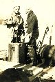 |
A hand sounding machine. On the EXPLORER |
North Pacific Ocean 1927 |
3587 |  |
Installation of deepsea sounding equipment. C&GS 1931 Hydrographic Manual |
1931 |
3588 |  |
LL type wireline sounding machine. C&GS 1942 Hydrographic Manual |
|
3589 |  |
Early continuous sounding record from acoustic system. Off of OCEANOGRAPHER. C&GS didn't use recording instruments until late 1930's |
Hudson Canyon area 1939 |
3590 |  |
Submarine valley discovered in Georges Bank area. Work done by OCEANOGRAPHER |
Georges Bank, offshore Massachusetts 1931 |
3591 |  |
Submarine valleys of Georges Bank. Contoured by Dr. Francis P. Shepard, "the father of marine geology". Work done by OCEANOGRAPHER |
Georges Bank, offshore Massachusetts 1932 |
3592 |  |
The Mendocino Escarpment. The initial indication of the great seafloor fracture zones. Surveyed by GUIDE between 1935-1938 |
Cape Mendocino, California 1938 |
3593 |  |
First discoveries of PIONEER and GUIDE Seamounts. Seamounts discovered by PIONEER and GUIDE. |
Central California 1929-1932 |
3594 |  |
Davidson Seamount named for George Davidson of the C&GS. This feature was the first called a "seamount". Officially named by the U.S. Board on Geographic Names. Discovered by GUIDE in 1933. Error - latitude should range from 35 to 36 |
South of Monterey, California 1934 |
3595 |  |
Identified as submerged atolls on Palawan Bank. Note similarity in shape to salt structures in Gulf of Mexico. See images "theb.3833.htm" and "theb.3834.htm" |
Palawan Bank, Philippine Islands 1933 |
3596 |  |
Shallow water bathymetry. Sand waves off Padre Island. Delineation possible because of widespread use of recording fathometers |
Padre Island, Texas 1948 |
3597 |  |
The first guyot -discovered by Harry Hess of Princeton University. Flat-topped seamounts which are common in the Pacific. Discovered by Hess as naval officer in WWII. Contrary to popular belief, flat- topped seamounts were first discovered by the C&GS in the Gulf of Alaska and published on by Harold Murray in 1941. |
Western Pacific 1945? |
3598 |  |
Precision depth recorder record of small seamount on side of Easter Island. Acquired by Scripps Institution of Oceanography. Record from ship THOMAS G. WASHINGTON |
Easter Island 1982 |
3599 |  |
Profile of Bowers Bank. Surveyed by PATHFINDER |
Southern Bering Sea 1952 |

