| 1600 |  |
The Challenger Reports. Vol. IX, Plate LXXVIII. The Foraminifera. Globigerina. Orbulina universa, d'Orbigny. |
|
1601 |  |
The Challenger Reports. Vol. IX, Plate LXXIX. The Foraminifera. Globigerina. 1-7, Globigerina bulloides, d'Orbigny. 8-10, Globigerina inflata, d'Orbigny. 11-16, Globigerina rubra, d'Orbigny. 17, Globigerina dubia, Egger. |
|
1602 | 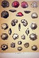 |
The Challenger Reports. Vol. IX, Plate XCVI. The Foraminifera. Planorbulina ( Truncatulina). See Image expl3018. |
|
1603 |  |
The Challenger Reports. Vol. IX, Plate XCVI. The Foraminifera. Planorbulina ( Truncatulina). Accompanying text. |
|
1604 | 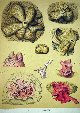 |
The Challenger Reports. Vol. IX, Plate C. The Foraminifera. Carpenteria_ Polytrema. 1-4, Carpenteria utricularis, Carter. 5-9, Carpenteria miniaceum, Linne, sp. |
|
1605 |  |
The Challenger Reports. Vol. IX, Plate CI. The Foraminifera. Polytrema_ Tinoporus (Tinoporus_Gypsina). Accompanying text. |
|
1606 |  |
The Challenger Reports. Vol. IX, Plate CI. The Foraminifera. Polytrema_ Tinoporus (Tinoporus_Gypsina). See expl3020 for accompanying text. |
|
1607 |  |
The Challenger Reports. Vol. IX, Plate CXV. The Foraminifera. Pulvinulina_ Rotalia, etc. Accompanying text. |
|
1608 |  |
The Challenger Reports. Vol. IX, Plate CXV. The Foraminifera. Pulvinulina_ Rotalia, etc. |
|
1609 |  |
The Challenger Reports, Volume XXI, Plate I. The Hexactinellida, Euplectella aspergillum Owen. A glass sponge, popularly known as "Venus's flower basket." Collected in the Philippine Islands at a depth of 100 fathoms. |
|
1610 |  |
The Challenger Reports, Volume XXI, Plate VII. The Hexactinellida, Taegeria pulchra F.E. Schulze. A glass sponge. |
|
1611 |  |
The Challenger Reports, Volume XXI, Plate XLIV. The Hexactinellida, Pheronema giganteum, F.E. Schulze. A glass sponge. |
|
1612 |  |
The Challenger Reports, Volume XXI, Plate XLIV. The Hexactinellida, Periphragella elisae, Marshall. A glass sponge. |
|
1613 |  |
The Challenger Reports, Report on Deep Sea Deposits. Fragments of pumice and manganese-iron nodules. Plate I. |
|
1614 |  |
The Challenger Reports, Report on Deep Sea Deposits. Manganese-iron nodules. Plate II. |
|
1615 |  |
The Challenger Reports, Report on Deep Sea Deposits. Manganese-iron nodules. Plate II, accompanying text. |
|
1616 | 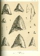 |
The Challenger Reports, Report on Deep Sea Deposits. Shark's teeth. (Carcharodon, Carcharias, &c.) Plate V. |
|
1617 |  |
The Challenger Reports, Report on Deep Sea Deposits. Shark's teeth. (Carcharodon, Carcharias, &c.) Plate V, accompanying text. |
|
1618 |  |
The Challenger Reports, Report on Deep Sea Deposits. Calcareous Deposits. Plate XXIV. |
|
1619 |  |
The Challenger Reports, Report on Deep Sea Deposits. Shark's teeth. (Oxyrhina, Lamna, &c.) Plate VI, accompanying text. |
|
1620 |  |
The Challenger Reports, Report on Deep Sea Deposits. Shark's teeth. (Oxyrhina, Lamna, &c.) Plate VI. |
|
1621 |  |
The Challenger Reports, Report on Deep Sea Deposits. Deep-Sea Deposits. Chart I. A map of the world-wide distribution of deep sea deposits by John Murray. |
|
1622 |  |
The Challenger Reports, Report on Deep Sea Deposits. Calcareous Deposits. Plate XII. |
|
1623 |  |
The Challenger Reports, Report on Deep Sea Deposits. Calcareous Deposits. Plate XXIV. Representative casts which are formed in and on Foraminiferous shells and other calcareous organisms in different varieties of marine deposits. |
|
1624 |  |
The Challenger Reports, Report on Deep Sea Deposits. Various phases assumed by glauconite. |
|
1625 |  |
The Challenger Reports, Report on Deep Sea Deposits. Various phases assumed by glauconite. Accompanying text. |
|
1626 |  |
Cover of "The Sinking of the TITANIC and Other Great Sea Disasters" edited by Logan Marshall, published 1912. |
|
1627 |  |
A graphic comparing the TITANIC to the largest structures in the world at the time of the sinking. In: "The Sinking of the TITANIC...." Logan Marshall, 1912. P. 30. |
|
1628 |  |
Artist's rendition of "Heartbreaking farewells" on the TITANIC. In: "The Sinking of the TITANIC...." Logan Marshall, 1912. P. 41. |
|
1629 |  |
The nature of the injury sustained by the TITANIC. In: "The Sinking of the TITANIC...." Logan Marshall, 1912. P. 63. |
|
1630 | 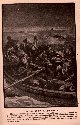 |
In the drifting lifeboats of the TITANIC. In: "The Sinking of the TITANIC...." Logan Marshall, 1912. P. 72. |
|
1631 | 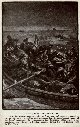 |
In the drifting lifeboats of the TITANIC. In: "The Sinking of the TITANIC...." Logan Marshall, 1912. P. 72. |
|
1632 |  |
Graphic showing depth of ocean where the TITANIC sank. Subsequently it has been discovered that the TITANIC rests in approximately 2080 fathoms. In: "The Sinking of the TITANIC...." Logan Marshall, 1912. P. 88. |
|
1633 |  |
A biblical reference in the context of the TITANIC disaster. In: "The Sinking of the TITANIC...." Logan Marshall, 1912. P. 98. |
|
1634 | 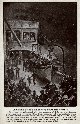 |
Artist's rendition of the lowering of the lifeboats from the TITANIC. In: "The Sinking of the TITANIC...." Logan Marshall, 1912. P. 104. |
|
1635 |  |
Artist's rendition of the lifeboats pulling away from the sinking TITANIC. In: "The Sinking of the TITANIC...." Logan Marshall, 1912. P. 105. |
|
1636 | 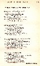 |
"Where Manhood Perished Not," A poem about the TITANIC by Harvey F. Thew, who was later destined to become a famous film writer. In: "The Sinking of the TITANIC...." Logan Marshall, 1912. P. 105. |
|
1637 |  |
An eyewitness impression of the sinking of the TITANIC by Jack Thayer. In: "The Sinking of the TITANIC...." Logan Marshall, 1912. P. 201. |
|
1638 |  |
First map of an oceanic basin. Matthew Fontaine Maury produced this map in 1853 and published it in the Wind and Current Charts for that year. |
|
1639 |  |
Second map of an oceanic basin. Matthew Fontaine Maury produced this map in 1854 and published it in the Wind and Current Charts for that year. This map had significantly more data than the 1853 map including soundings by Lt. Otway Berryman, USN, on the USS DOLPHIN over the Mid-Atlantic Ridge (MAR) north of the Azores. These were the first soundings on the MAR. |
|
1640 |  |
Bottom characteristic map of the approaches to New York Harbor by "United States Hydrographical Office" as published in Matthew Fontaine Maury's Wind and Current Charts for 1858. Data from United States Coast Survey. Note there is no expression of Hudson Canyon below the continental shelf break although the channel of the Ice Age Hudson River is clearly shown. |
|
1641 |  |
First profile of an oceanic basin. Matthew Fontaine Maury produced this profile in 1854 and published it in the Wind and Current Charts for that year. |
|
1642 |  |
An early example of a microscopic examination of ocean bottom sediment. This was published with a report by Lt. Joseph Dayman, RN, who ran a line of sounding s across the Atlantic Ocean from Newfoundland to Ireland on HMS CYCLOPS in 1857. This was the second line run and covered the same ground sounded by Lt. Otway Berryman for the USCS on the ARCTIC in 1856. |
|
1643 |  |
Sounding on the HMS CYCLOPS in mid-Atlantic Ocean in August 1857. The diagram on the right shows the problem with early hemp sounding line methods. The line would keep running out after reaching bottom and the surveyors would not be able to ascertain an accurate depth. |
|
1644 |  |
Top panel same as image map00006. Bottom panel demonstrates method of detaching weight and retrieving bottom sample such that the surveyor would at least know that the sounding weight had reached bottom. However, this did not improve the accuracy of the sounding. |
|
1645 |  |
Western section of survey line run by Lt. Joseph Dayman on HMS CYCLOPS during telegraph cable survey of 1857. The work of Berryman and Dayman between in 1856 and 1857 respectively marked a new era in ocean exploration, the beginning of systematic surveys, in this case to determine a telegraph cable route. |
|
1646 |  |
Middle section of survey line run by Lt. Joseph Dayman on HMS CYCLOPS during telegraph cable survey of 1857. The work of Berryman and Dayman between in 1856 and 1857 respectively marked a new era in ocean exploration, the beginning of systematic surveys, in this case to determine a telegraph cable route. |
|
1647 |  |
Eastern section of survey line run by Lt. Joseph Dayman on HMS CYCLOPS during telegraph cable survey of 1857. The work of Berryman and Dayman between in 1856 and 1857 respectively marked a new era in ocean exploration, the beginning of systematic surveys, in this case to determine a telegraph cable route. |
|
1648 |  |
Cover to the publication by Lt. Joseph Dayman detailing the work of running the first lines of soundings across the Atlantic Ocean as part of an intentional planned survey. |
|
1649 |  |
In 1858, Matthew Fontaine Maury modified his 1854 map to show the Telegraphic Plateau extending east-west across the Atlantic Ocean and an area of relatively shoal ground which he called Middle Ground. The Telegraphic Plateau actually extended through much of what is known today as the Charlie Gibbs Fracture Zone with no high mountains giving the illusion of a plateau. |
|

