Oregon Seal
Text-Only Site State Directory Agencies A-Z Accessibility
  Advanced
Help
www.oregon.gov

South Slough National Estuarine Research Reserve

Logos of SSNERR, NOAA, and NERRS


Menu
About Us

Contact Us

South Slough Home

NERRS CDMO

Welcome & Introduction

Research

Education

Stewardship

Coastal Training Program

Community Involvement

Friends of South Slough

Maps and Directions

Events Calendar

Newsletter

Resource Library

Management Commission

Meetings

 
Get Outside!
Explore South Slough
Egrets grace the shore of the estuary.
The best way to experience the glory of South Slough is to get outside and explore the estuary. A wide variety of adventuresome options are at your fingertips—explore them all!
 
South Slough is pleased to offer monthly interpretive hiking and paddling tours. For information on upcoming trips, check out the current activities calendar or call the Interpretive Center (541)888-5558.

Walking and Hiking
Cedars and madrones tower above the trail.
From the Interpretive Center...
There are two major trailheads found at the Interpretive Center:
 
10-minute interpretive nature trail
This short hike loops around the upland forest and has several upland forest plants identified.  A interpretive photo field guide is available from the Interpretive Center for use on this short walk.
 
Down to the Slough
There are several trails which take you down to the Slough.  The longest is a moderate three mile loop down the watershed and back.  Visitors with special needs can obtain access to the Slough; please contact the Interpretive Center for more information (541)888-5558.

From the South Entrance...
Two trail systems exist at the south entrance of the South Slough Reserve:
 
Wasson and Winchester Trails
Tour an old homestead and orchard and hike through a mature forest to a freshwater marsh and back.
 
Anderson Creek Trail
View current restoration efforts and keep your eyes open for elk!

Trail Maps
Download and print your own maps  before you go!

Paddling
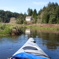
The Fredrickson house, as seen from Winchester Creek.
Serene waters
The best way to get to know South Slough is from the water itself! Once you are on the serene waters, you will start to truly understand the magnitude of the tides and begin to grasp the forces shaping this beautiful landscape.

Paddling Guides
Before you take to the water, responsible and careful planning is a must. Weather and tides can be unpredictable, so please plan accordingly; using our paddling guide  is a great start.
 
Reserve staff have created an aerial map using GIS software, detailing landmarks and areas of interest on South Slough. 
 
Washington State University has compiled a gear list for sea kayaking, which is relevant for any boater in our region.

Tide Tables
Tide tables from the Hatfield Marine Science Center are essential for planning your paddling trip.

Regional Trails
Beyond South Slough, there are multiple opportunities to get active on the Oregon South Coast.  The Coos Regional Trails Partnership provides information on regional land and water trails in the Coos/Curry areas.

Text Only | State Directory | Agencies A-Z | About Oregon.gov

Oregon.gov | Site Map | File Formats | OAR | ORS | Privacy Policy | Web Site Feedback