| Home >> | Advanced Search >> |
 |
|
Astronaut Photography of Earth - Display Record
STS108-720-32

Low-resolution Browse Image
(Most browse images are not color adjusted.)Images
Conditions for Use of Images >>Image Transformation Tutorial >> Saving, Color Adjusting, and Printing Images >>
Images to View on Your Computer Now
| File Name | File Size (bytes) | Width | Height | Annotated | Cropped | Purpose | Comments | |
|---|---|---|---|---|---|---|---|---|
| View | STS108-720-32.JPG | 57790 | 515 | 512 | No | No | From ISD Photo CDs | |
| View | STS108-720-32.JPG | 178698 | 540 | 540 | Yes | Yes | NASA's Earth Observatory web site | |
| View | STS108-720-32.JPG | 806586 | 1279 | 1301 | No | NASA's Earth Observatory web site | ||
| View | STS108-720-32_2.JPG | 203093 | 400 | 400 | Yes | Photographic Highlights |
Large Images to Request for Downloading
| File Name | File Size (bytes) | Width | Height | Annotated | Cropped | Purpose | Comments | |
|---|---|---|---|---|---|---|---|---|
| Request | STS108-720-32.JPG | 188963 | 1031 | 1024 | No | No | From ISD Photo CDs | |
| Request | STS108-720-32_2.JPG | 553844 | 2063 | 2048 | No | No | From ISD Photo CDs | |
| Request | STS108-720-32_3.JPG | 1423741 | 4127 | 4096 | No | No | From ISD Photo CDs | |
| Request | STS108-720-32.JPG | 806586 | 1279 | 1301 | No | Photographic Highlights | ||
| Request | STS108-720-32_2.TIF | 3215794 | 1265 | 1232 | No | No | ||
| Request | STS108-720-32.TIF | 3471780 | 1301 | 1279 | No | No |
Download a Keyhole Markup Language (KML) file for use in Google Earth.
Electronic Image Data
Camera files only apply to electronic still cameras.No sound file available.
Identification
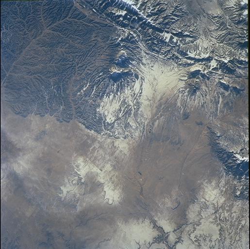
Mission: STS108 Roll: 720 Frame: 32 Mission ID on the Film or image: STS108Country or Geographic Name: USA-NEW MEXICO
Features: SPANISH PEAKS, SNOW
Center Point Latitude: 37.5 Center Point Longitude: -105.0 (Negative numbers indicate south for latitude and west for longitude)
Stereo: (Yes indicates there is an adjacent picture of the same area)
ONC Map ID: JNC Map ID:
Camera
Camera Tilt: 50Camera Focal Length: 110mm
Camera: HB: Hasselblad
Film: 5069 : Kodak Elite 100S, E6 Reversal, Replaces Lumiere, Warmer in tone vs. Lumiere.
Quality
Film Exposure:Percentage of Cloud Cover: 10 (0-10)
Nadir
Date: 20011213 (YYYYMMDD)GMT Time: 214053 (HHMMSS)Nadir Point Latitude: 35.9, Longitude: -108.8 (Negative numbers indicate south for latitude and west for longitude)
Nadir to Photo Center Direction: East
Sun Azimuth: 217 (Clockwise angle in degrees from north to the sun measured at the nadir point)
Spacecraft Altitude: 207 nautical miles (383 km)
Sun Elevation Angle: 21 (Angle in degrees between the horizon and the sun, measured at the nadir point)
Orbit Number: 126
Captions
The Spanish Peaks, on the eastern flank of the Sangre de Cristo range, abruptly rise 7,000 feet above the western Great Plains. Settlers, treasure hunters, trappers, gold and silver miners have long sighted on these prominent landmarks along the Taos branch of the Santa Fe trail. Well before the westward migration, the mountains figured in the legends and history of the Ute, Apache, Comanche, and earlier tribes. “Las Cumbres Españolas” are also mentioned in chronicles of exploration by Spaniards including Ulibarri in 1706 and later by de Anza, who eventually founded San Francisco (California).This exceptional view (STS108-720-32), captured by the crew of Space Shuttle mission STS108, portrays the Spanish Peaks in the context of the southern Rocky Mountains. Uplift of the Sangre de Cristo began about 75 million years ago and produced the long north-trending ridges of faulted and folded rock to the west of the paired peaks. After uplift had ceased (~26 to 22 million years ago), the large masses of igneous rock (granite, granodiorite, syenodiorite) that form the Peaks were emplaced (Penn, 1995-2001). East and West Spanish Peaks are “stocks”—bodies of molten rock that intruded sedimentary layers, cooled and solidified, and were later exposed by erosion. East Peak (E), at 12,708 ft is almost circular and is about 5 1/2 miles long by 3 miles wide, while West Peak (W), at 13,623 ft is roughly 2 3/4 miles long by 1 3/4 miles wide.
Great dikes—long stone walls—radiate outward from the mountains like spokes of a wheel, a prominent one forms a broad arc northeast of East Spanish Peak. As the molten rock rose, it forced its way into vertical cracks and joints in the sedimentary strata; the less resistant material was then eroded away, leaving walls of hard rock from 1 foot to 100 feet wide, up to 100 feet high, and as long as 14 miles. Dikes trending almost east-west are also common in the region.
Download Packaged File.
This option downloads the following items, packaged into a single file, if they are available:
- Browse image
- Cataloged information with captions
- Camera file
- Sound file
Server: 2 |
This service is provided by the International Space Station program. |
Recommended Citation: |
||

