
|
||
Toshka Lakes, Southern Egypt
| ||||
High resolution photograph, December 1999 (1.5 MB)
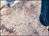
New lakes in southern Egypt have been monitored by astronauts since 1998. This animation links together several photographs of the region taken by astronauts to show the sequence of flooding in the Toshka depression. The flooding was first documented in early November 1998. Subsequently, three additional lakes were created by Lake Nasser overflow, as shown by the above photograph (STS103-712-7) taken in December of 1999. Estimates of areas of the lakes were made after the images were registered to a common image base. The region will be the location of large Egyptian agricultural developments that will support millions of people. Additional photographs of the region taken by Astronauts can be viewed at NASA-JSC's Earth Sciences Home Page. The Moderate-resolution imaging spectroradiometer (MODIS) captured these lakes on February 9, 2000 (2.4 MB), October 10, 2000, and November, 2000 (2.1 MB). Image provided by the Earth Science and Image Analysis Laboratory, Johnson Space Center Recommend this Image to a Friend Back to: Newsroom
Also see |
View Images Index
| |||
|
Subscribe to the Earth Observatory About the Earth Observatory Contact Us Privacy Policy and Important Notices Responsible NASA Official: Lorraine A. Remer Webmaster: Goran Halusa We're a part of the Science Mission Directorate |
 Click here to view animation