
Coupled Bio-physical models
|
For Our Current Modeling Results ...
Including movies of the Bering Sea, Gulf of Alaska, and California Coast, please, see the NEP modeling page.Coastal Gulf of Alaska
Modeling Efforts from 1997 through 2000
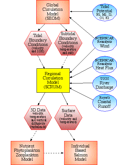
| Our project consists of four interconnected models - two physical and two biological. The Spectral Element Ocean Model (SEOM) is run for a global domain and will provide boundary conditions for the S-Coordinate Rutgers University Model (SCRUM), the regional model of the Coastal Gulf of Alaska. Output from the regional circulation model will be used to drive the Nutrient-Phytoplankton-Zooplankton (NPZ) model of the near-coastal area encompassing the shelf and shelf break. Circulation and prey fields produced in this manner will then be used as input to the spatially explicit Individual Based Model (IBM) of juvenile salmon. Our goal is to create a means of investigating interannual and decadal changes in the physical environment of the CGOA, while exploring linkages between physical forcing and biological production. |
A brief description of our project can be found at the GLOBEC
Northeast Pacific Program web page.
And a brief description of our progress, as of April 1999, can be found in
basically the same place.
And we have submitted a
manuscript to Progress in Oceanography.
Global Circulation Model

A large-scale context for our regional studies is provided by simulations with the Spectral Element Ocean Model. SEOM has been developed for the purpose of high-resolution basin-scale modeling on unstructured global grids. The governing equations are the 3-D, Reynolds-averaged Navier-Stokes equations with Boussinesq and hydrostatic assumptions. Subgridscale mixing is parameterized using spatially dependent lateral mixing in the horizontal. The resulting class of large-scale circulation models has several significant virtues over those using more traditional approaches, including complete geometric flexibility, regionally selective horizontal resolution, and the ability to avoid open boundary conditions by use of global grid refinement.
Here, SEOM has been implemented on a global grid in layered form (5 layers). It has been spun up with 5 years of a repeating cycle of NCEP winds, corresponding to the period of NCSAT wind availability.
Regional Circulation Model
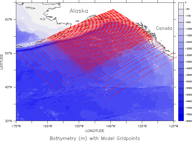
Model Domain
|
The finely resolved area of the model domain
reaches from the northeast corner to Queen Charlotte
Island in the south and Unimak Pass in the west. The telescoped region
continues to the south end of Vancouver Island, and to Amukta Pass in the west.
Grid resolution varies between 22 km to 200 km.
Click image to enlarge it |
 |
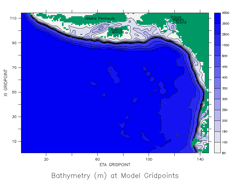
SCRUM
The S-Coordinate Rutgers University model (SCRUM) is a free surface, primitive equation model. Curvilinear-orthogonal coordinates in the horizontal allow the grid to follow the coastal boundary, while the stretched, bottom-following "s-coordinate" allows for flexible spacing of vertical grid points. The latter feature is especially useful in resolving boundary layers at the top of the water column (important for wind mixing) and near the bottom (important for tidal mixing).Our CGOA implementation of SCRUM is forced by winds, coastal runoff and
atmospheric heat flux. It is spun-up from rest in mid-January,
with climatology-derived initial temperature and salinity fields. The
grid has 145 x 113 horizontal gridpoints with 17 telescoped
gridpoints on the southern and western boundaries. There are 20 vertical
levels in a bottom following coordinate system (S-coordinates). Model
bathymetry was interpolated from a 5 minute data set based on ETOPO5 that is
particularly accurate in the CGOA, and was filtered to increase the model's
stability. Land areas are masked after the calculation of each timestep.
Click image to enlarge it
Features that can be included
- NCEP/NCAR Reanalysis winds
- NCEP/NCAR Reanalysis heat flux
- Integrated freshwater input along the coast
- Susitna and Copper River discharge
- Vertical S coordinates manipulated so that top layer is constant depth across the entire domain
- Initial temperature and salinity fields from Levitus data
- Nudging of temperature and salinity to Levitus data
- Nudging of barotropic velocity to output from SEOM
- Tidal forcing derived from SEOM results
- A filter for writing out unaliased results with tidal
SCRUM Results
- Runs without nudging
to climatology or subtidal (spring 1995, spring 1997, all of 1976).
Includes a virtual reality display of float trajectories. - Runs nudged with climatology and subtidal barotropic velocities (fall 1996)
- Run with tidal forcing (fall 1996)

 http://www.pmel.noaa.gov/~dobbins/scrum_cgoa/cgoa.html