
 |
 |
Floater |
Gulf of Mexico |
Western Atlantic |
||||||||||||||||||||||||||||||||||||||||||||||||||||||||||||||||||||||||||||||||||||||||||||||||||||||||||||
Loop - September 24/0015Z to 24/1345Z |
Loop - September 24/0015Z to 24/1345Z |
Loop - September 24/0015Z to 24/1345Z |
||||||||||||||||||||||||||||||||||||||||||||||||||||||||||||||||||||||||||||||||||||||||||||||||||||||||||||
Enhancement Abbreviation Key
AVI Loops
September |
Loop Type |
Enhancement |
Size |
||||
| 19/0645Z to 24/2345Z | Gulf of Mexico |
20-22 Mb |
|||||
| 24/0015Z to 24/2345Z | Floater |
4-5 Mb |
|||||
| 22/2245Z to 23/2345Z | Floater |
4-5 Mb
|
|||||
| 20/0715Z to 21/0845Z | Floater |
4-5 Mb
|
|||||
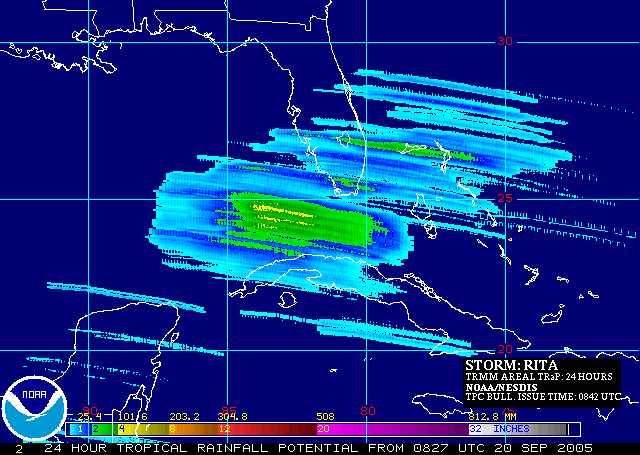
| Tropical Rainfall Potential (TRaP) | September 23 | 03:04:04.GIF | 03:41:04.GIF | |
| Tropical Rainfall Potential (TRaP) | September 23 | 20:56:59.GIF | 20:58:07.GIF | |
| 05:57:19.GIF | 13:39:06.GIF | 15:25:05.GIF | ||
| Tropical Rainfall Potential (TRaP) | September 22 | 09:59:47.GIF | 15:03:51.GIF | 16:05:34.GIF |
| Tropical Rainfall Potential (TRaP) | September 20 | 11:08:00.GIF | ||
| Tropical Rainfall Potential (TRaP) | September 19 | 05:37:27.GIF | 09:04:42.GIF | 10:24:18.GIF |
| Tropical Rainfall Potential (TRaP) | September 18 | 22:02:04.GIF | ||
Hurricane Rita Operational Significant Event Imagery
September |
Satellite | "preview" | Full Size |
24 |
GOES 12 | TRCRita267_G12L.jpg | TRCRita267_G12.jpg |
23 |
GOES 12 | TRCrita266_G12L.jpg | TRCrita266_G12.jpg |
22 |
GOES 12 | TRCrita265_G12L.jpg | TRCrita265_G12.jpg |
21 |
GOES 12 | TRCrita264_G12L.jpg | TRCrita264_G12.jpg |
20 |
GOES 12 | TRCrita263_G12L.jpg | TRCrita263_G12.jpg |
| TRC2rita263_G12L.jpg | TRC2rita263_G12.jpg |
AVN |
Aviation color enhancement |
BD |
Dvorak enhancement - used for Tropical Classifications with the Dvorak Technique |
FT |
Funktop enhancement - developed by Ted Funk for assistance with Precipitation analysis |
IR2 |
Channel 2 Infrared imagery - Shortwave, sometimes considered "night visible" |
IR4 |
Unenhanced Channel 4 Infrared Imagery |
JSL |
JSL2 enhancement - developed by Jim Lynch for use with tropical classifications |
RB |
Rainbow enhancement curve - pretty color enhancement |
RGB |
Combination of Visible and IR using a three channel technique to make features stand out |
VIS |
Unenhanced Visible imagery that changes to IR2 overnight. |
WV |
Water Vapor, IR Channel 3 with color enhancement |
Imagery between 0345Z and 0615Z may be from GOES-10 due to GOES-12 being in eclipse.
|
Contact Information: |
||
|
You are Here: http://www.ssd.noaa.gov/GOES/2005/Rita/index.html
|