|
|
 |
| Press Release Images |
 |
| Return to Press Release Images index |
|
|
Full Res JPG (1.27 MB)
Planetary Science Institute site
|
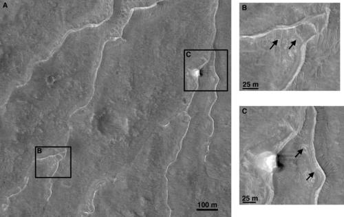
Inverted Channels North of Valles Marineris
Features believed to indicate where channels used to flow on Mars can be seen in this image taken by the High Resolution Imaging Science Experiment (HiRISE) camera in NASA's Mars Reconnaissance Orbiter.
The sinuous white lines are interpreted as inverted channels. Insets B and C highlight examples if locations where light-toned beds are exposed within and between the inverted channels. Inverted channels form on Earth when sediment is deposited in streambeds over time. When the streams dry up, the surrounding, softer terrain erodes away, leaving the harder, cemented sediments in the former streambeds standing above the surrounding terrain.
The images are from an observation HiRISE made on April 4, 2007, of plains west of Juventae Chasma, which is a canyon north of Mars' huge Valles Marineris canyon system. The scale bar in the main image is 100 meters (328 feet). The scale bars in the inset images are 25 meters (82 feet).
Additional image products from the same HiRISE observation,catalogued as PSP_003223_1755, are available at http://hirise.lpl.arizona.edu/PSP_003223_1755 .
NASA/JPL-Caltech/Univ. of Arizona
|
|
|
JPL Image Use Policy
|