| Home >> | Advanced Search >> |
 |
|
Astronaut Photography of Earth - Display Record
ISS005-E-13929
Low-resolution Browse Image
(Most browse images are not color adjusted.)Images
Conditions for Use of Images >>Image Transformation Tutorial >> Saving, Color Adjusting, and Printing Images >>
Images to View on Your Computer Now
| File Name | File Size (bytes) | Width | Height | Annotated | Cropped | Purpose | Comments | |
|---|---|---|---|---|---|---|---|---|
| View | ISS005-E-13929.JPG | 48216 | 540 | 357 | Yes | Yes | NASA's Earth Observatory web site | |
| View | ISS005-E-13929.JPG | 62412 | 639 | 435 | No | No | From STIC, color adjusted | |
| View | ISS005-E-13929.JPG | 144212 | 1000 | 662 | No | Yes | NASA's Earth Observatory web site | Color adjusted |
Large Images to Request for Downloading
| File Name | File Size (bytes) | Width | Height | Annotated | Cropped | Purpose | Comments | |
|---|---|---|---|---|---|---|---|---|
| Request | ISS005-E-13929.JPG | 870323 | 3032 | 2008 | No | Yes | NASA's Earth Observatory web site | Color adjusted |
| Request | ISS005-E-13929.JPG | 1038916 | 3032 | 2064 | No | No | From STIC, color adjusted | |
| Request | ISS005-E-13929.TIF | 18280904 | 3032 | 2008 | No | No | Reef RS | From STIC, color adjusted |
Download a Keyhole Markup Language (KML) file for use in Google Earth.
Electronic Image Data
Camera Files >> No sound file available.Identification
Mission: ISS005 Roll: E Frame: 13929 Mission ID on the Film or image: ISS005Country or Geographic Name: USA-HAWAII
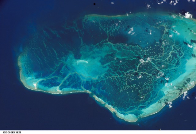
Features: PEARL AND HERMES REEF
Center Point Latitude: 28.0 Center Point Longitude: -176.0 (Negative numbers indicate south for latitude and west for longitude)
Stereo: (Yes indicates there is an adjacent picture of the same area)
ONC Map ID: JNC Map ID:
Camera
Camera Tilt: 37Camera Focal Length: 400mm
Camera: E4: Kodak DCS760C Electronic Still Camera
Film: 3060E : 3060 x 2036 pixel CCD, RGBG array.
Quality
Film Exposure:Percentage of Cloud Cover: 10 (0-10)
Nadir
Date: 20020912 (YYYYMMDD)GMT Time: 205038 (HHMMSS)Nadir Point Latitude: 26.1, Longitude: -174.2 (Negative numbers indicate south for latitude and west for longitude)
Nadir to Photo Center Direction: Northwest
Sun Azimuth: 113 (Clockwise angle in degrees from north to the sun measured at the nadir point)
Spacecraft Altitude: 211 nautical miles (391 km)
Sun Elevation Angle: 45 (Angle in degrees between the horizon and the sun, measured at the nadir point)
Orbit Number: 1774
Captions
Measuring Water Depth from the International Space Station:Looking out the window of the International Space Station, astronauts often take the time to admire and photograph tropical islands and coral reefs. From an altitude of 400 km and with only a digital camera as a tool, it seems impossible to make detailed measurements of the depth of underwater features. However, a new technique developed by NOAA scientists has done just that—plotted the depths of lagoon features at Pearl and Hermes Reef, northwest Hawaii, using digital astronaut photography from the International Space Station (ISS).
Measuring water depth is an important step in mapping coral reef environments. Even though digital cameras are designed to visually approximate film photographs, the information they collect is similar to the bands of different wavelengths of light collected by multispectral instruments on satellites. NOAA scientists developed an algorithm that could estimate bathymetry from the blue and green bands in IKONOS satellite data. After calibrating the astronaut photography to the signal in the IKONOS data, the same algorithm could be successfully used with the blue and green channels in the astronaut photography. An accuracy assessment of the bathymetry map shows good correspondence between reference data, IKONOS, and ISS data.
Analysis of the Pearl and Hermes imagery was completed by Rick Stumpf and Kris Holderied at the NOAA National Ocean Service. NOAA NOS’s most recent coral reef mapping activities have focused on producing benthic habitat maps of the Northwest Hawaiian Islands for the Office of National Marine Sanctuaries. NOAA has primary responsibility for mapping activities in U.S.-Flag waters under the U.S. Coral Reef Task Force’s Mapping Implementation Plan. Partnership with Julie Robinson, Earth Observations Laboratory (Lockheed Martin), Johnson Space Center, has been facilitated by NASA support for Coral Reef Remote Sensing projects and collaborations.
References:
Stumpf, R. P., K. Holderied, J. A. Robinson, G. Feldman, N. Kuring. Mapping water depths in clear water from space. Coastal Zone 03, Baltimore, Maryland, 13-17 July 2003. http://eol.jsc.nasa.gov/newsletter/CoastalZone/
Stumpf, R.P. K. Holderied, and M. Sinclair. 2003b. Determination of water depth with high-resolution satellite imagery over variable bottom types. Limnology and Oceanography 48(1, part 2):547-556.
Download Packaged File.
This option downloads the following items, packaged into a single file, if they are available:
- Browse image
- Cataloged information with captions
- Camera file
- Sound file
Server: 2 |
This service is provided by the International Space Station program. |
Recommended Citation: |
||

