Hot, dry Santa Ana winds began blowing through the Los Angeles and San
Diego areas on Sunday October 21, 2007. Wind speeds ranging from 30 to 50
mph were measured in the area, with extremely low relative humidities.
These winds, coupled with exceptionally dry conditions due to lack of
rainfall resulted in a number of fires in the Los Angeles and San Diego
areas, causing the evacuation of more than 250,000 people.
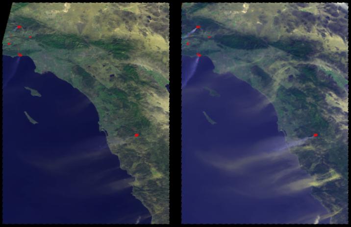
These two images show the Southern California coast from Los Angeles to
San Diego from two of the nine cameras on the Multi-angle Imaging
SpectroRadiometer (MISR) instrument on the NASA EOS Terra satellite. These
images were obtained around 11:35 a.m. PDT on Sunday morning, October 21,
2007 and show a number of plumes extending out over the Pacific ocean. In
addition, locations identified as potential hot spots from the Moderate
Resolution Imaging Spectroradiometer (MODIS) instrument on the same
satellite are outlined in red.
The left image is from MISR's nadir looking camera and the plumes appear
very faint. The image on the right is from MISR's 60° forward looking
camera, which accentuates the amount of light scattered by aerosols in the
atmosphere, including smoke and dust. Both these images are false color
and contain information from MISR's red, green, blue and near-infrared
wavelengths, which makes vegetated land appear greener than it would
naturally. Notice in the right hand image that the color of the plumes
associated with the MODIS hot spots is bluish, while plumes not associated
with hot spots appear more yellow. This is because the latter plumes are
composed of dust kicked up by the strong Santa Ana winds. In some
locations along Interstate 5 on this date, visibility was severely reduced
due to blowing dust. MISR's multiangle and multispectral capability give
it the ability to distinguish smoke from dust in this situation.
The Multi-angle Imaging SpectroRadiometer observes the daylit Earth
continuously and every 9 days views the entire globe between 82 degrees
north and 82 degrees south latitude. These images were generated from a
portion of the imagery acquired during Terra orbit 41713, and use data
from blocks 63 to 66 within World Reference System-2 path 40.
MISR was built and is managed by NASA's Jet Propulsion Laboratory,
Pasadena, CA, for NASA's Office of Earth Science, Washington, DC. The
Terra satellite is managed by NASA's Goddard Space Flight Center,
Greenbelt, MD. The MISR data were obtained from the NASA Langley Research
Center Atmospheric Science Data Center. JPL is a division of the
California Institute of Technology.

