| Home >> | Advanced Search >> |
 |
|
Astronaut Photography of Earth - Display Record
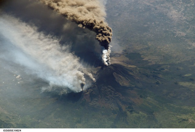
ISS005-E-19024
Low-resolution Browse Image
(Most browse images are not color adjusted.)Images
Conditions for Use of Images >>Image Transformation Tutorial >> Saving, Color Adjusting, and Printing Images >>
Images to View on Your Computer Now
| File Name | File Size (bytes) | Width | Height | Annotated | Cropped | Purpose | Comments | |
|---|---|---|---|---|---|---|---|---|
| View | ISS005-E-19024.JPG | 65134 | 639 | 435 | No | No | From STIC, color adjusted | |
| View | ISS005-E-19024.JPG | 186994 | 1000 | 760 | No | No | NASA's Earth Observatory web site | |
| View | ISS005-E-19024.JPG | 220363 | 540 | 410 | Yes | Yes | NASA's Earth Observatory web site | |
| View | ISS005-E-19024.JPG | 223418 | 540 | 409 | Photographic Highlights | (540 px resized images) | ||
| View | ISS005-E-19024.JPG | 236893 | 540 | 405 | Scientist Request | Online Publication |
Large Images to Request for Downloading
| File Name | File Size (bytes) | Width | Height | Annotated | Cropped | Purpose | Comments | |
|---|---|---|---|---|---|---|---|---|
| Request | ISS005-E-19024.JPG | 616378 | 1000 | 758 | Photographic Highlights | (actual files used) | ||
| Request | ISS005-E-19024.JPG | 822716 | 1024 | 768 | Yes | Presentation | Color adjusted | |
| Request | ISS005-E-19024.JPG | 1199670 | 3032 | 2064 | No | No | From STIC, color adjusted |
Download a Keyhole Markup Language (KML) file for use in Google Earth.
Electronic Image Data
Camera Files >> No sound file available.Identification
Mission: ISS005 Roll: E Frame: 19024 Mission ID on the Film or image: ISS005Country or Geographic Name: SICILY
Features: MOUNT ETNA ERUPTION
Center Point Latitude: 38.0 Center Point Longitude: 15.0 (Negative numbers indicate south for latitude and west for longitude)
Stereo: (Yes indicates there is an adjacent picture of the same area)
ONC Map ID: JNC Map ID:
Camera
Camera Tilt: High ObliqueCamera Focal Length: 800mm
Camera: E4: Kodak DCS760C Electronic Still Camera
Film: 3060E : 3060 x 2036 pixel CCD, RGBG array.
Quality
Film Exposure:Percentage of Cloud Cover: 10 (0-10)
Nadir
Date: 20021030 (YYYYMMDD)GMT Time: 113028 (HHMMSS)Nadir Point Latitude: 43.1, Longitude: 14.9 (Negative numbers indicate south for latitude and west for longitude)
Nadir to Photo Center Direction: South
Sun Azimuth: 193 (Clockwise angle in degrees from north to the sun measured at the nadir point)
Spacecraft Altitude: 205 nautical miles (380 km)
Sun Elevation Angle: 32 (Angle in degrees between the horizon and the sun, measured at the nadir point)
Orbit Number: 2517
Captions
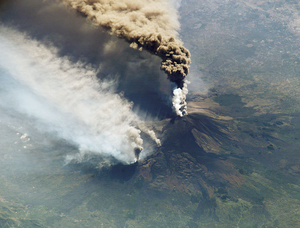
International Space Station crew members are trained to observe and document dynamic events on the Earth’s surface, such as hurricanes, forest fires, and volcanic eruptions. Their observations provide scientists and the general public a different perspective on these events. Earlier this week, astronauts in the crew of the ISS-5 mission were able to observe Mt. Etna’s spectacular eruption, and photograph the details of the eruption plume from the summit. Both of these images are looking obliquely to the southeast over the island of Sicily. The wide view (ISS005-E-19016) shows the ash plume curving out toward the horizon, caught first by low-level winds blowing to the southeast, and to the south toward Africa at higher altitudes. Ashfall was reported in Libya, more than 350 miles away. The lighter-colored plumes downslope and north of the summit (see detailed view, ISS005-E-19024) are produced by gas emissions from a line of vents on the mountain's north flank. The detailed image provides a more three-dimensional profile of the eruption plume.This was one of Etna’s most vigorous eruptions in years. The eruption was triggered by a series of earthquakes on October 27. These images were taken on October 30, 2002. Sicilans have learned to live with Etna’s eruptions. Although schools were closed and air traffic was diverted because of the ash, no towns or villages were threatened by the lava flow.
Link to Earth Observatory Caption >>
Download Packaged File.
This option downloads the following items, packaged into a single file, if they are available:
- Browse image
- Cataloged information with captions
- Camera file
- Sound file
Server: 2 |
This service is provided by the International Space Station program. |
Recommended Citation: |
||

