| 500 |  |
Hurricane Eloise east of Louisiana approaching west Florida |
9/22/75 2029Z |
501 |  |
Hurricane Belle southeast of Charleston, South Carolina |
8/8/76 1801Z |
502 |  |
Hurricanes Emmy and Frances in the north central Atlantic Ocean |
8/30/76 1231Z |
503 |  |
Hurricanes Emmy and Frances displaying Fujiwhara effect |
8/31/76 1231Z |
504 |  |
Hurricane Frances in the north central Atlantic Ocean |
8/31/76 1931Z |
505 |  |
Hurricane Madeline in Pacific Ocean |
10/7/76 2015Z |
506 |  |
Hurricane Anita in central Gulf of Mexico |
8/30/77 1730Z |
507 |  |
Hurricane Anita southwest of Southwest Pass of Mississippi River |
8/30/77 2100Z |
508 |  |
Hurricane Anita approaching the coast of Mexico south of Brownsville |
9/01/77 2001Z |
509 |  |
Hurricane Anita approaching landfall on the coast of Mexico |
09/01/77 |
510 |  |
Hurricane Heather in Pacific Ocean |
10/5/77 1901Z |
511 |  |
Tropical Storm Debra in west central Gulf of Mexico |
8/27/78 2201Z |
512 |  |
Tropical Storm Debra approaching landfall near the Texas-Louisiana border |
8/28/78 2101Z |
513 |  |
Tropical Storm Debra approaching landfall near the Texas-Louisiana border |
8/28/78 2301Z |
514 |  |
Hurricane Ella approaching closest point of approach to U.S. mainland |
9/01/78 1732Z |
515 |  |
Hurricane Ella near closest point of approach to U.S. mainland |
9/01/78 1831Z |
516 |  |
Hurricane Ella near closest point of approach to U.S. mainland Within a few hours of this image Ella made a right-angle turn to the northeast The storm then accelerated towards the northeast and skirted Newfoundland |
9/01/78 2201Z |
517 |  |
Hurricane Norman south of Cabo San Lucas, Baja California |
9/01/78 2231Z |
518 |  |
Hurricane Norman south of Cabo San Lucas, Baja California |
9/02/78 1601Z |
519 |  |
Hurricane Greta skirting the north shore of Honduras |
9/17/78 2204Z |
520 |  |
Hurricane Greta in the Gulf of Honduras |
9/18/78 1534Z |
521 |  |
Hurricane Greta making landfall at Belize |
9/18/78 1801Z |
522 |  |
Typhoon Kerry east of the Solomon Islands |
2/13/79 0600Z |
523 |  |
Typhoon Kerry east of the Solomon Islands |
2/13/79 0600Z |
524 |  |
Typhoon Kerry in Coral Sea |
2/20/79 0148Z |
525 |  |
Typhoon Kerry in the Coral Sea |
2/19/79 0600Z |
526 |  |
Hurricane David - in tropical wave stage in eastern tropical Atlantic Ocean On far right of image. |
8/23/79 1730Z |
527 |  |
Hurricane David approaching the Caribbean Sea. |
8/28/79 1330Z |
528 |  |
Hurricane David making landfall on the Georgia coast. |
9/4/79 2100Z |
529 |  |
Hurricane Fred approaching landfall in Mississippi |
9/12/79 1800Z |
530 |  |
Hurricane Fred after landfall |
9/12/79 22Z |
531 |  |
Hurricane Andrew - visible image from METEOSAT 3 Andrew was approaching the Florida coast |
|
532 |  |
Hurricane Andrew - water vapor satellite image by METEOSAT 3 August 19, 1992 image also shows upper level low to the north of Andrew |
|
533 |  |
Hurricane Andrew - infrared image at maximum intensity August 23, 1992 |
|
534 |  |
Hurricane Andrew - visible satellite image taken by METEOSAT 3 This picture depicts Andrew during period of maximum intensity over Bahamas August 23, 1992 |
|
535 |  |
Hurricane Andrew - infrared image taken by GOES 7 Andrew is crossing the Florida coast and making landfall August 24, 1992, at Dade County, Florida |
|
536 |  |
Hurricane Andrew - WSI radar composite of Andrew making landfall August 24, 1992, at Dade County, Florida |
|
537 |  |
Hurricane Andrew - WSR-88D radar image as Andrew made landfall August 24, 1992 at Dade County, Florida |
|
538 |  |
Hurricane Andrew - Storm tide data and contours in feet - green area inundated August 24, 1992 at Dade County, Florida |
|
539 |  |
Hurricane Andrew -Sewell Park at the mouth of the Miami River On a normal day |
|
540 |  |
Hurricane Andrew -Sewell Park at the mouth of the Miami River Just after daybreak on August 24, 1992 |
|
541 |  |
Hurricane Andrew - The marina Gables by the Sea after the storm surge |
|
542 |  |
Hurricane Andrew - Kings Bay townhomes @ $750K each Double whammy from Andrew - upper windows blown out by winds before eye Debris in foreground result of storm surge moving through lower levels |
|
543 | 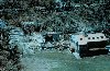 |
Hurricane Andrew - Buildings on the Deering Estate Still-water marks from storm surge measured at 16.5 feet |
|
544 |  |
Hurricane Andrew - An ocean-going tugboat left high and dry by storm surge. Boat is on the 174th Street side of the canal. Road in the background is old Cutler Road. A storm surge of 16.9 feet occurred a few blocks from here at the Burger King world headquarters. |
|
545 |  |
Hurricane Andrew - Even the chief executive officer wasn't spared Office of Corporate Executive Officer of Burger King World Headquarters |
|
546 |  |
Hurricane Andrew - Two vehicles remain in garage but overturned by force of wind |
|
547 | 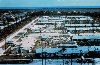 |
Hurricane Andrew - A section of Pinewoods Villa Note uneven damage pattern |
|
548 |  |
Hurricane Andrew - A ground view of the devastation in Pinewoods Villa |
|
549 |  |
Hurricane Andrew - Another view of the Pinewoods Villa area |
|