Henri was a tropical storm with maximum 1-min surface winds of 50 kt in the eastern Gulf of Mexico. After weakening to a depression, it moved across central Florida, where it dumped up to ten inches of rainfall.
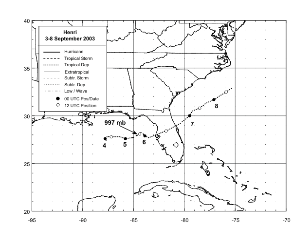
Henri formed from a tropical wave that moved from Africa to the tropical Atlantic Ocean on 22 August. The wave reached the eastern Gulf of Mexico on 1 September where the northern portion became nearly stationary, while the southern portion continued westward. By 1800 UTC on 3 September, the associated convection and low-level circulation became well-enough organized about 260 n mi west of Tampa, Florida to become Tropical Depression Twelve.
The "best track" chart of the tropical cyclone's path starts on the 3 September and is plotted in Figure 1; the wind and pressure histories are plotted in Figure 2 and Figure 3, respectively. The complete best track positions and intensities are listed in Table 1.
The depression was embedded in the southern portion of a slow-moving mid-latitude trough and moved slowly eastward. The depression became a tropical storm at 0600 UTC , 5 September and the wind speed increased to its maximum value of 50 kt on 1800 UTC on that day even though there was at least 20 kt of southwesterly vertical shear affecting the circulation. The winds quickly weakened to 30 kt before Henri, preceded and accompanied by heavy rain, accelerated northeastward across north-central Florida on the 6 September. Over the southwestern North Atlantic Ocean, Henri slowed its forward speed on 7 September when it became trapped to the south of a shallow high pressure system. Strong vertical shear finally led to its dissipation when the depression lost a well-defined low-level circulation and simultaneously became involved with a frontal zone resulting in a spreading out of the wind field. The broad and disorganized extratropical low remained nearly stationary off the coast of the Carolinas for several days and moved inland over North Carolina on 12-13 September.
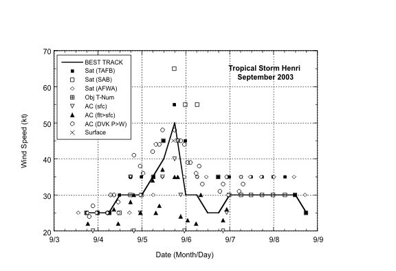
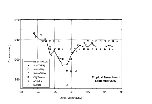
Wind speed estimates in Henri are based on satellite-based Dvorak technique intensity estimates from the Tropical Analysis and Forecast Branch (TAFB), the Satellite Analysis Branch (SAB) and the U. S. Air Force Weather Agency (AFWA), as well as flight-level and dropwindsonde observations from flights of the 53rd Weather Reconnaissance Squadron of the U. S. Air Force Reserve Command. These estimates and observations are plotted in Figure 2. Minimum central pressure data are plotted in Figure 3.
There were no ship reports of tropical storm force winds. On 5 September, a reconnaissance aircraft reported an 850-mb flight level wind speed of 46 kt at 1116 UTC, along with 997 mb surface pressure. Data buoy 42036, located in the northeastern Gulf of Mexico, reported a 10-min. mean wind speed of 45 kt with a gust to 64 kt at 1720 UTC on the same day. This buoy also reported a surface pressure of 1001.7 mb at 1750 UTC. Henri was centered about 25 n mi east-southeast of the buoy at the time of the 45-kt wind speed. Based on these reports, Henri's highest 1-min wind speed is estimated at 50 kt at 1800 UTC. Note in Figure 2 that subjective Dvorak wind speed estimates based on satellite imagery were as high as 55 to 65 kt. Based on aircraft data, as well as the buoy, Henri's maximum wind speed quickly decreased to 30 kt during the next six hours as the low level center became totally exposed. Then Henri crossed over Florida as a tropical depression.
Henri's rain affected much of Florida. There were five to ten inches of rain in portions of Charlotte County. There was generally minor freshwater flooding in two areas: from Sarasota through Lee Counties , and a small portion of southern Hernando and extreme northern Pasco County. In southern Florida and in the panhandle area, rainfall totals were generally less than two inches.
There were no deaths attributed to Henri. However, a male in Lee County was injured when struck by lightning from a thunderstorm in a feeder band. Also, an indirect injury occurred when a vehicle driven by a Pinellas Park man hydro-planed into a concrete wall on Interstate 275 in Tampa. Damage from flooding was generally minor.
Average official track errors (with the number of cases in parentheses) for Henri were 44 (18),73 (16), 83 (14), 97 (12), 82 (8), and 124 (4) n mi for the 12, 24, 36, 48, 72, and 96 h forecasts, respectively1. These errors are lower than the average official track errors for the 10-yr period 1993-20022 (45, 81, 116, 150, 225, and 282, n mi, respectively). Henri did not last long enough to verify any 120-h forecasts.
Average official intensity errors were 5, 8, 7, 8, 8, and 3 kt for the 12, 24, 36, 48, 72, and 96 h forecasts, respectively. For comparison, the average official intensity errors over the 10-yr period 1993-2002 are 6, 10, 13, 15, 19, and 21 kt, respectively.
Table 2 lists the watches and warnings issued for Henri.
1 All forecast verifications in this report include the depression stage of the cyclone. National Hurricane Center verifications presented in these reports prior to 2003 did not include the depression stage.
2 Errors given for the 96 h periods are averages over the two-year period 2001-2002.
| Date/Time (UTC) | Position | Pressure (mb) | Wind Speed (kt) | Stage | |
|---|---|---|---|---|---|
| Lat. (°N) | Lon. (°W) |
||||
| 03 / 1800 | 27.4 | 87.7 | 1013 | 25 | tropical depression |
| 04 / 0000 | 27.6 | 87.8 | 1011 | 25 | " |
| 04 / 0600 | 27.8 | 87.6 | 1009 | 25 | " |
| 04 / 1200 | 27.8 | 87.2 | 1010 | 30 | " |
| 04 / 1800 | 27.8 | 86.3 | 1002 | 30 | " |
| 05 / 0000 | 27.6 | 85.8 | 1004 | 30 | " |
| 05 / 0600 | 27.7 | 85.1 | 1000 | 35 | tropical storm |
| 05 / 1200 | 28.1 | 84.4 | 997 | 40 | " |
| 05 / 1800 | 28.3 | 84.2 | 997 | 50 | " |
| 06 / 0000 | 27.9 | 83.9 | 1002 | 30 | tropical depression |
| 06 / 0600 | 27.7 | 83.5 | 1005 | 30 | " |
| 06 / 1200 | 28.4 | 81.8 | 1007 | 25 | " |
| 06 / 1800 | 29.2 | 80.4 | 1006 | 25 | " |
| 07 / 0000 | 30.0 | 79.5 | 1006 | 30 | " |
| 07 / 0600 | 30.5 | 79.2 | 1008 | 30 | " |
| 07 / 1200 | 30.8 | 78.5 | 1006 | 30 | " |
| 07 / 1800 | 31.3 | 77.9 | 1006 | 30 | " |
| 08 / 0000 | 31.7 | 77.1 | 1006 | 30 | " |
| 08 / 0600 | 32.1 | 76.5 | 1007 | 30 | " |
| 08 / 1200 | 32.5 | 75.9 | 1006 | 30 | " |
| 08 / 1800 | 32.9 | 75.3 | 1006 | 25 | extratropical |
| 09 / 0000 | dissipated | ||||
| 05 / 1800 | 28.3 | 84.2 | 997 | 50 | minimum pressure |
| 06/0900 | 27.9 | 82.8 | 1006 | 30 | landfall near Clearwater, FL |
| Date/Time | Action | Location |
|---|---|---|
| 03/2100 | tropical storm warning issued | Englewood to Indian Pass, Florida |
| 05/0000 | tropical storm warning discontinued | Aucilla River to Indian Pass |
| 06/0300 | tropical storm warning discontinued | Swannee River to Aucilla |
| 06/0900 | all warnings discontinued |
Figure 1: Best track positions for Tropical Storm Henri, 3-8 September 2003.
Figure 2: Selected wind observations and best track maximum sustained surface wind speed curve for Tropical Storm Henri, 3-8 September 2003. Aircraft observations, when available, have been adjusted for elevation using 90%, 80%, and 80% reduction factors for observations from 700 mb, 850 mb, and 1500 ft, respectively.
Figure 3: Selected pressure observations and best track minimum central pressure curve for Tropical Storm Henri, 3-8 September 2003.
Tropical Cyclone Reports
Ana -
Two -
Bill -
Claudette -
Danny -
Six -
Seven -
Erika -
Nine -
Fabian -
Grace -
Henri -
Isabel -
Fourteen -
Juan -
Kate -
Larry -
Mindy -
Nicholas -
Odette -
Peter
Get Storm Info
Satellite Imagery -
US Weather Radar -
Aircraft Recon -
Advisory Archive -
Mobile Products -
E-Mail Advisories -
RSS Feeds -
About NHC Products
Tropical Analysis and Forecasting
Atlantic Products -
E Pac Products -
About TAFB Products
Learn About Hurricanes
Hurricane Awareness -
Frequently Asked Questions -
AOML Hurricane-Research Division -
Hurricane Hunters -
The Saffir-Simpson-Hurricane Scale -
Forecasting Models -
Inland Wind Model -
Eyewall Wind-Profiles -
TPC Glossary -
TPC Acronyms -
Storm Names
Breakpoints
Hurricane History
NHC/TPC Archives -
Forecast Verification -
Climatology -
1492-1996 (Atlantic) -
1900-2000 (USA) -
Most Expensive -
Most Intense -
US Strikes by Decade -
US Strikes by State
About Us
About the TPC -
Mission/Vision -
Other NCEP Centers -
TPC Personnel -
NOAA Locator -
Visitor Information -
NHC Library -
WX4NHC Amateur Radio Station
NOAA/
National Weather Service
National Centers for Environmental Prediction
National Hurricane Center
Tropical Prediction Center
11691 SW 17th Street
Miami, Florida, 33165-2149 USA
nhcwebmaster@noaa.gov
Disclaimer
Privacy Policy
Credits
About Us
Glossary
Career Opportunities
Page last modified: Monday, 07-Feb-2005 16:38:05 GMT