| 1000 |  |
Kite reel in use at Weather Bureau Aerological Stations. In: Monthly Weather Review, April 1919, p. 206. |
1919 Circa |
1001 |  |
Front view of Marvin kite meteorograph in use at Weather Bureau Aerological Stations. In: Monthly Weather Review, April 1919, p. 206. |
1919 Circa |
1002 |  |
Kite and balloon theodolite in use at Weather Bureau, Military and Naval Aerological Stations. In: Monthly Weather Review, April 1919, p. 206. |
1919 Circa |
1003 |  |
Preparing to launch America's first "ballon-sonde." Since this first launch, literally millions of weather balloons have been launched by the National Weather Service and its predecessor organization. In: "The Principles of Aerography" by Alexander McAdie, 1917. Page 12. |
St. Louis, Missouri 1904 September 15 |
1004 | 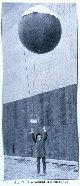 |
Launching a "ballon-sonde", probably at St. Louis. The French were the first to use small balloons filled with hydrogen to carry meteorological instruments aloft. In: "The Principles of Aerography" by Alexander McAdie, 1917. Page 13. |
1905 Circa |
1005 |  |
Filling the balloon of a "ballon-sonde" prior to launch. The French were the first to use small balloons filled with hydrogen to carry meteorological instruments aloft. In: "The Principles of Aerography" by Alexander McAdie, 1917. Page 14. |
St. Louis, Missouri 1905 Circa |
1006 |  |
Revolving kite and balloon shed at Mount Weather Observatory. In: "Yearbook of the United States Department of Agriculture. 1906." 1907, p. 122. |
Mount Weather, Virginia 1906 |
1007 |  |
The Siegsfeld kite balloon at Mount Weather Observatory. In: "Yearbook of the United States Department of Agriculture. 1906." 1907, p. 122. |
Mount Weather, Virginia 1906 |
1008 |  |
Hargrave-Martin box kites as used at Mount Weather Observatory. In: "Yearbook of the United States Department of Agriculture. 1906." 1907, p. 122. |
Mount Weather, Virginia 1906 |
1009 |  |
Alfred Lorenz with a theodolite for tracking weather balloons. |
North Platte, Nebraska 1930 December |
1010 |  |
Kite being prepared for launching with kite-reel house in the background. Image obtained from an old glass lantern slide. |
1910 Circa |
1011 | 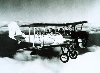 |
Navy bi-plane with meteorograph on starboard wing strut Taking meteorological measurements for pressure, temperature, and humidity Manned flights were inefficient for routine observations as cost high Manned flights grounded during poor weather, thus radiosonde balloons replaced However, such flights paved the way for aircraft weather research projects |
Washington, D.C. December 13, 1934 |
1012 |  |
Microwave antenna deployed from back end of C-130 aircraft Measuring surface wind speeds and wave height - First deep-ocean wave measurement in a hurricane - 40 foot waves measured Testing in Pacific Hurricane Ava, a vigorous130-knot storm This was the first penetration of a Pacific hurricane by a NOAA aircraft |
300 miles SW of Acapulco, Mexico June 6, 1973 |
1013 |  |
Cargo door of C-130 open while Robert Berles adjusts down-pointing laser Laser measuring wave height directly below NOAA C-130 aircraft Measurements taken during a winter storm experiment in North Atlantic |
Winter 1975 |
1014 |  |
Weather Bureau DC-6 personnel during Project Storm Fury Storm Fury was a hurricane cloud seeding experiment |
Miami, Florida 1966 |
1015 |  |
Attaching a meteorograph to the strut of a bi-plane |
Ca. 1930 |
1016 |  |
Friez type aerometeorograph, the instrument carried on Weather Bureau observatio n aircraft. It automatically recorded temperature, relative humidity, and pressure. Here it has its protective cover and is mounted between the wings of a bi-plane. In: "Monthly Weather Review," April 1935, p. 126. |
|
1017 |  |
Friez type aerometeorograph, the instrument carried on Weather Bureau observatio n aircraft. It automatically recorded temperature, relative humidity, and pressure. In: "Monthly Weather Review," April 1935, p. 126. |
|
1018 |  |
Three black widow P-61 night fighters silhouetted against a thunderhead prior to separating and penetrating the thunderstorm at three different levels for meteorological readings. These planes were an intrinsic part of "The Thundersto rm Project," the classic first large-scale experiment to study atmospheric phenomena. In: "Weatherwise," Vol. 1, No. 3, June 1948, cover. |
1947 Circa |
1019 |  |
In general agreement that this was an inappropriate place to launch a meteorological rocket. |
Circa 1968 |
1020 |  |
Weighing a rocket prior to launch assuring the right amount of fuel on board. |
Circa 1968 |
1021 |  |
Securing the nose cone of an Atlantic Research Corporation meteorological rocket prior to launch. |
Circa 1968 |
1022 |  |
Preparing an ARCAS meteorological rocket for launch. |
Circa 1968 |
1023 |  |
Preparing a meteorological rocket for launch. |
Circa 1968 |
1024 |  |
Preparing to launch a rocket for upper air observations. |
Circa 1968 |
1025 |  |
Launching a rocket for upper air observations. |
Circa 1968 |
1026 |  |
Launching a rocket for upper air observations. |
Circa 1968 |
1027 |  |
"Launching a Weather Bureau Kite from the "SENECA" during the International Ice Patrol, to Explore the Air over the Ocean." In: "Meteorology" by Charles F. Talman, 1922. P. 289. Library Call Number M T151m. |
|
1028 |  |
Exploring the upper air. Left: Beginning of a pilot balloon flight. Right: Sending up a sounding balloon. Note the parachute which wafts the basket of instruments gently to the ground after the balloon bursts. In: "Meteorology" by Charles F. Talman, 1922. Library Call Number M T151m. |
Circa 1920 |
1029 |  |
Top: "Meteorograph for use with sounding balloon." Bottom: "Kite Meteorograph." In: "Meteorology" by Charles F. Talman, 1922. P. 33. |
|
1030 |  |
"A snow surveyor at work. Note the cylindrical snow sampler, with its serrated cutting edge, and spring balance for weighing the sample of snow." In: "Meteorology" by Charles F. Talman, 1922. P. 289. Library Call Number M T151m. |
|
1031 |  |
"Gaging the thirst of the air." The observer is measuring the depth of water in the evaporation pan with a graduated glass tube (burette.) In: "The Realm of the Air" by Charles F. Talman, 1931. Library Call Number M/0030 T151r. |
1925 circa |
1032 |  |
"Measuring rainfall." Showing the standard eight-inch rain gauge used by the Weather Bureau. In: "The Realm of the Air" by Charles F. Talman, 1931. Library Call Number M/0030 T151r. |
|
1033 |  |
Instrument shelter as shown on old fashioned glass lantern slide. |
1915 Circa |
1034 |  |
Instrument shelter as shown on old fashioned glass lantern slide. |
|
1035 |  |
Building an instrument shelter - possibly for use with cooperative observing network. From an old-fashioned glass lantern slide. |
|
1036 |  |
Building an instrument shelter - possibly for use with cooperative observing network. From an old-fashioned glass lantern slide. |
|
1037 |  |
Antennas, probably at Greenbury Point, Maryland, in about 1920. These were U. S. Navy communications antennas meant to communicate with Europe during the First World War and probably also with ships. Perhaps this slide was meant to illustrate the potential of wireless radio communication for weather dissemination. From an old-fashioned glass lantern slide. |
Greenbury Point, Maryland ? 1920 circa |
1038 |  |
SCR-658 radio direction finder used to track radiosonde balloons Termed "bedsprings" antenna |
1945-1946? |
1039 |  |
SCR-658 radio direction finder used to track radiosonde balloons Woman observer indicates WWII or just after war time frame World War II expanded the opportunities for women in the Weather Bureau |
1945-1946 |
1040 |  |
The track of Hurricane Donna as tracked by radar - Photo #1 of sequence Not the first hurricane seen on radar, this was the best tracked at time |
|
1041 |  |
The track of Hurricane Donna as tracked by radar - Photo #2 of sequence Not the first hurricane seen on radar, this was the best tracked at time |
|
1042 |  |
The track of Hurricane Donna as tracked by radar - Photo #3 of sequence Not the first hurricane seen on radar, this was the best tracked at time |
|
1043 |  |
The track of Hurricane Donna as tracked by radar - Photo #4 of sequence Not the first hurricane seen on radar, this was the best tracked at time |
|
1044 |  |
The track of Hurricane Donna as tracked by radar - Photo #5 of sequence Not the first hurricane seen on radar, this was the best tracked at time |
|
1045 |  |
The track of Hurricane Donna as tracked by radar - Photo #6 of sequence Not the first hurricane seen on radar, this was the best tracked at time |
|
1046 |  |
The track of Hurricane Donna as tracked by radar - Photo #7 of sequence Not the first hurricane seen on radar, this was the best tracked at time |
|
1047 |  |
The track of Hurricane Donna as tracked by radar - Photo #8 of sequence Not the first hurricane seen on radar, this was the best tracked at time |
|
1048 |  |
The track of Hurricane Donna as tracked by radar - Photo #9 of sequence Not the first hurricane seen on radar, this was the best tracked at time |
|
1049 |  |
The track of Hurricane Donna as tracked by radar - Photo #10 of sequence Not the first hurricane seen on radar, this was the best tracked at time |
|