Text Size: A+| A-| A   |   Text Only Site   |   Accessibility
A woodland scene
Forest Health Management in Oregon
Program Overview
Insect & Disease Pest Notes
Invasive Species
Survey Maps & Data
Program Overview
Forest Health Specialist inside the cockpit during an aerial survey.
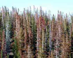
Aerial surveys are completed annually on all Oregon forests.
 
 
"Our mission is to maintain and improve the health of Oregon's non-federal forests."
 
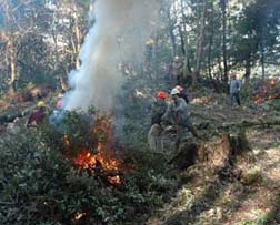
The Department's forest health professionals conduct surveys, evaluations, and monitor forest insects and tree diseases. They provide technical advice and training in the use of integrated pest management principles to help professional foresters and landowners meet their management goals and objectives.
 
Family forestland owners requiring additional information or technical assistance can contact their local ODF stewardship forester.
 
 
Forest Health Highlights - Joint Publications of Oregon Department of Forestry & USDA Forest Service, Pacific Northwest Region
 

Insect & Disease Pest Notes
Damage from bark beetles and other agents can lead to landscape-level tree mortality that may increase the risk of catastrophic fire.
Tree damage/mortality increases risk of catastropic fire.
Bark Beetles:
 

Borers: Defoliators:
Shoot & Twig Insects:
Sucking Insects:
 
Foliage Diseases:  
Root Diseases:

Other Damage

For additional information, try:

Invasive Species
Treatments to limit the spread of sudden oak death in Oregon include the removal of infected and susceptible hosts in areas of detection.
Treatments to remove infected and susceptible SOD hosts.
Sudden Oak Death
Sudden Oak Death is the common name for a disease caused by Phytophthora ramorum. Tree mortality, branch and shoot dieback, and leaf spots result from infection depending on host species and location. Below are a few exceptional resources for more information on this disease and its hosts, symptoms, eradication efforts and more:
 
 
Port Orford Cedar Root Disease (USDA Forest Service)
 
White Pine Blister Rust (USDA Forest Service)
 
Gypsy Moth (ODA Plant Division)
 
Asian Longhorn Beetle (ODA Plant Division) Adult Asian Longhorn Beetle
 
Emerald Ash Borer (USDA Forest Service)

Survey Maps & Data
Aerial survey plane flying over forested hillside.
Aerial survey of Oregon forestlands celebrates its 60th year
 
 
The maps and data files below can take one to several minutes (depending on your connection speed) to load. Please be aware that many of these files require freeware for you to view/download. Links to freeware known to work well with these file types can be found here.    


Statewide I&D Cooperative Aerial Surveys
Maps  
GIS Data¹
Metadata²
2007 Statewide Aerial Survey

2007 Aerial Survey (zip)
Oregon Lambert Projection
(7.9 MB)
Data dictionary (description of Cooperative Aerial Survey data)
2006 Statewide Aerial Survey
2006 Aerial Survey (zip)
Oregon Lambert Projection
(6.2 MB)
Data dictionary (description of Cooperative Aerial Survey data)
2005 Statewide Aerial Survey
2005 Aerial Survey (zip)
Oregon Lambert Projection
(3.9 MB)
Data dictionary (description of Cooperative Aerial Survey data)
2004 Aerial Survey (zip)
Oregon Lambert Projection
(4.8 MB)
Data dictionary (description of Cooperative Aerial Survey data)
2003 Aerial Survey (zip)
Oregon Lambert Projection
(5.3 MB)
Data dictionary (description of Cooperative Aerial Survey data)
Swiss Needle Cast (SNC)
 
 
Maps  
GIS Data¹
Metadata²
2007 SNC 
(1.2 MB)
2007 SNC Data (zip)
(1.32 MB)
2006 SNC 
(1.1 MB)
2006 SNC Data (zip)
(1.3 MB)
 
2005 SNC 
(1 MB)
2005 SNC Data (zip)
(517 KB)
 
2004 SNC
(1 MB)
2004 SNC Data (zip)
(549.12 KB)
 
2003 SNC
(1.07 MB)
2003 SNC Data (zip)
(847.80 KB)
 
2002 SNC 
(1.07 MB)
2002 SNC Data (zip)
(885.67 KB)
 
2001 SNC
(1.04 MB)
2001 SNC Data (zip)
(933.65 KB)
 
2000 SNC
(1.07 MB)
2000 SNC Data (zip)
(850.07 KB)
2000 SNC Coverage (txt) (10.92 KB)
1999 SNC
(1.03 MB)
1996-1999 SNC Data (zip)
(4.74 MB)
 
1998 SNC
(1.04 MB)
  1996-1998 SNC coverage (txt) (11.29 KB)
1997 SNC
(1.02 MB)
   
1996 SNC
(1 MB)
   
____________
¹
GIS Data - Download compressed files (.zip) to your computer allowing you to import the data into your own GIS application. To uncompress these files requires WinZip™ (freeware).
²
Metadata Text Files - Information about the variables, and how the surveys were conducted, for those using the ArcInfo files.

 
Page updated: January 29, 2008

Get Adobe Acrobat ReaderAdobe Reader is required to view PDF files. Click the "Get Adobe Reader" image to get a free download of the reader from Adobe.