 |
| Storm Reports |
| Are you interested in what happened during a recent event? Check out the
report below. |
|
|
 |
July 2007 Storm Report |
 |
| |
| Short Weather Summary |
| |
| Persistent
heavy rainfall in the southern Plains built into Arkansas to begin July.
Central and southern sections of the state received well above normal
precipitation. During the latter half of the month, rain shut off in
most areas as high pressure to the west began to assert itself. While
temperatures heated up some, readings for July averaged below normal. |
|
| There were three record low temperatures tied or broken
at North Little Rock (Pulaski County) toward the end of July. Check
the records below... |
| Site |
Record
Low (Date of Occurrence) |
| North Little Rock |
65T (07/22), 65 (07/23),
66T (07/24) |
| Note:
"T" means record was tied. |

|
High pressure to the west created a northwest wind aloft
over Arkansas. This kept a steady flow of cold fronts arriving from the
north...with cooler than normal temperatures. |
|
In the picture: The pattern on 07/20/2007...with high pressure
("H") to the west creating a northwest wind flow aloft. |
| The fronts tended to stall in southern sections of the
state, with precipitation building along the fronts from Oklahoma and
Texas. |

|
| In the picture: An MCS (Mesoscale Convective
System or large cluster of thunderstorms) from the southern Plains
interacted with a stationary front in southern Arkansas during the
afternoon of 07/12/2007.�Precipitation became widespread across the
southwest half of the state. |
|
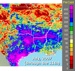
Through the first week and a half of July, rainfall was
over 200% of normal (and locally more than 600% of normal) in central
and southern Arkansas! With this much rain, the Arkansas River had very
high flow rates over 200,000 CFS (cubic feet per second) at times! Rates
should be 20,000 to 50,000 CFS. |
|
In the picture: Percent of normal rainfall in July, 2007 (through
the 11th). |
| In portions of northern and eastern Arkansas, it was a
different story. Heavy rain avoided these areas, with monthly totals
under 2 inches in some areas (less than 50% percent of normal in
places). As a result, drought conditions began to develop. |
| Rainfall
in July, 2007 |
| Site |
Rain
(07/01-07/12) |
Departure
(+/-) |
Rain
(07/13-07/31) |
Departure
(+/-) |
| Fayetteville (NW AR) |
2.65 |
+1.18 |
0.37 |
-1.20 |
| Harrison (NC AR) |
2.64 |
+1.47 |
0.13 |
-0.84 |
| Jonesboro (NE AR) |
2.66 |
+1.58 |
1.61 |
-0.04 |
| Fort Smith (WC AR) |
4.62 |
+3.25 |
0.64 |
-1.18 |
| Little Rock (C AR) |
2.30 |
+0.93 |
0.98 |
-0.96 |
| North Little Rock (C
AR) |
7.41 |
+6.16 |
0.33 |
-1.57 |
| West Memphis (EC
AR) |
1.92 |
+0.50 |
0.00 |
-1.90 |
| Texarkana (SW AR) |
5.53 |
+3.86 |
1.46 |
-0.65 |
| El Dorado (SC AR) |
4.91 |
+3.16 |
2.20 |
-0.18 |
| Monticello (SE AR) |
5.24 |
+3.43 |
1.84 |
-0.42 |
| Dry weather was the main theme in much of the state as
July came to a close. High pressure was more dominant, and rain was more
spotty. Temperatures also edged closer to normal levels, but without any
excessive heat. What is supposed to be the hottest month of the year
ended with no 100 degree readings. |
| In the Tropics |
| |
| There was only one tropical system in July.
Tropical Storm Chantal formed in the northern Atlantic between Bermuda and
Cape Cod on July 30th and 31st...and did not affect the eastern United
States. |
| Additional July Details |
| |
| For more details about
July, 2007...go to the "Temperatures and Precipitation"
section below. |
| Temperatures and Precipitation |
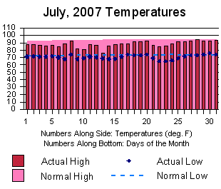
| Temperatures
were below normal in July. Readings at Little Rock are shown to right. |
 |
 |
Rainfall was generally at or below normal in parts of
northern and eastern Arkansas, and above normal elsewhere. Amounts at Little Rock are shown to left. |
| To right, a look at precipitation across the state. |
 |
| For a look at actual temperatures and precipitation
in Arkansas as measured by the cooperative observer network, click
here. |
|
|


