| NOAA Magazine || NOAA Home Page |
NOAA REPORTS LA NIÑA IS DEVELOPING
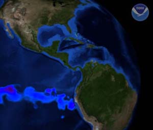
 September
6, 2007 — Scientists with NOAA’s Climate
Prediction Center, in today’s release of its monthly El Niño/Southern
Oscillation (ENSO) Diagnostic
Discussion, say that La
Niña is on its way. (Click NOAA image for larger
view of observed sea surface temperatures on August 29, 2007. Please
credit “NOAA.”)
September
6, 2007 — Scientists with NOAA’s Climate
Prediction Center, in today’s release of its monthly El Niño/Southern
Oscillation (ENSO) Diagnostic
Discussion, say that La
Niña is on its way. (Click NOAA image for larger
view of observed sea surface temperatures on August 29, 2007. Please
credit “NOAA.”)
“While we can’t officially call it a La Niña yet, we expect that this pattern will continue to develop during the next three months, meeting the NOAA definition for a La Niña event later this year,” said Mike Halpert, acting deputy director of the Climate Prediction Center in Camp Springs, Md.
La Niña refers to the periodic cooling of ocean surface temperatures in the central and east-central equatorial Pacific that occur every three to five years. NOAA declares the onset of a La Niña event when the three-month average sea-surface temperature departure exceeds -0.5 degrees Celsius (-0.9 degrees Fahrenheit) in the east-central equatorial Pacific [between 5 degrees North and 5 degrees South and 170 degrees West - 120 degrees West].
 The
development of La Niña conditions is supported by increasing
below-normal-sea surface temperatures across the central and eastern
equatorial Pacific and stronger-than-average easterly winds across the
west-central equatorial Pacific. “Nearly all operational dynamical
models, including the National Centers
for Environmental Prediction’s Climate
Forecast System and many of the statistical models also favor a
La Niña event,” said Halpert.
The
development of La Niña conditions is supported by increasing
below-normal-sea surface temperatures across the central and eastern
equatorial Pacific and stronger-than-average easterly winds across the
west-central equatorial Pacific. “Nearly all operational dynamical
models, including the National Centers
for Environmental Prediction’s Climate
Forecast System and many of the statistical models also favor a
La Niña event,” said Halpert.
(Click NOAA image for an animation (mov) of sea surface temperature (SSTs) anomalies across the Eastern Pacific as depicted by NOAA's Polar Operational Environmental Satellite. The blue and purple colors indicate areas of colder-than-average SSTs, indicative of a developing La Niña. Click here for high resolution version of the still image to the right. Please credit “NOAA.”)
With La Niña developing, seasonal forecasters expect wetter-than-normal conditions in the Pacific Northwest and drier-than-normal conditions in the already drought-stricken southwestern U. S. this Fall.
“These
conditions also reinforce NOAA’s
August forecast for an above normal Atlantic hurricane season,”
said Gerry Bell, Ph.D., NOAA’s lead seasonal hurricane forecaster.
The Climate Prediction Center routinely publishes an assessment of ENSO
conditions each Monday and the next official ENSO Diagnostic Discussion
will be issued on October 11, 2007. The El Niño/Southern Oscillation
Diagnostic Discussion is a product of the Climate Prediction Center
in association with its funded institutions.
NOAA is dedicated to enhancing economic security and national safety through the prediction and research of weather and climate-related events and information service delivery for transportation, and by providing environmental stewardship of our nation's coastal and marine resources. Through the emerging Global Earth Observation System of Systems (GEOSS), NOAA is working with its federal partners, more than 70 countries and the European Commission to develop a global monitoring network that is as integrated as the planet it observes, predicts and protects.
Relevant
Web Sites
NOAA
ENSO Diagnostic Discussion & Weekly Update
Atlantic Hurricane Season Outlook Update
Behind the Scene: NOAA’s North Atlantic Hurricane Season Outlook
Media
Contact:
Carmeyia Gillis, NOAA
Climate Prediction Center, (301) 763-8000 ext. 7163