January 7, 2008 Tornadoes in Far Southeast Wisconsin

Experiencing a tornado in Wisconsin in January is extremely rare. In fact, it had only happened once between 1950 and 2007, when an F3 tornado affected parts of Green and Rock Counties on January 24, 1967. That tornado in South Central Wisconsin was part of a much larger outbreak of 30 tornadoes across mostly Iowa, Illinois and Missouri. Wisconsin ended up with 30 tornadoes in 1967. The 30-year average annual number of tornadoes in Wisconsin is 21.
However, on the afternoon of January 7, 2008 a warm, moist, and unstable airmass, with temperatures rising into the lower 60s, moved into Southeast Wisconsin - setting the stage for a rare January severe weather event. Thunderstorms formed just ahead of a stationary front and produced hail, damaging winds, and a few tornadoes.
One of the thunderstorms tracked from just north of Rockford, Illinois into far Southeast Wisconsin. This supercell thunderstorm produced an EF-3 tornado in Northern Illinois. For more, visit the NWS Chicago writeup. The same storm also produced two tornadoes in Wisconsin. The first tornado spun up in Southeast Walworth County and then tracked through the Wheatland and Brighton areas of Western Kenosha County. The second tornado occurred in the town of Somers and on the north side of the city of Kenosha.
Below is a map of the two tornado tracks across Walworth and Kenosha Counties:

In Walworth County, five structures sustained damage - three had minor damage and two had moderate damage. In Kenosha County, with both tornadoes combined, 105 homes sustained damage. 46 homes had minor damage, 32 had major damage and 27 were destroyed.
The tornado in the Wheatland area also marked the first confirmed tornado in Kenosha County since 2001 - a span of nearly 7 years! Also, Kenosha County had only seen 4 tornadoes between 1950 and 2007. The last tornado observed in Walworth County was in 2004.
The three tornadoes in Southeast Wisconsin and Northern Illinois were also part of a larger tornado outbreak on January 7th. The majority of the tornadoes occurred in Missouri, where 33 have been confirmed. In all, 48 tornadoes occurred spanning an area from Southeast Wisconsin through Eastern Oklahoma. A map depicting tornado tracks from the entire outbreak is depicted below.

Other Writeups On This Event
NWS Chicago/Romeoville, IL NWS Lincoln, IL NWS St. Louis, IL NWS Springfield, MO NWS Tulsa, OK |
Wheatland Area Tornado
 BEGINNING     TIME  402 PM
           LOCATION  1.5 NE PELL LAKE /WALWORTH CO./

 ENDING        TIME  417 PM
           LOCATION  2.4 NW PADDOCK LAKE /KENOSHA CO./

 DURATION            15 MINUTES          EF-SCALE    EF-3
 PATH LENGTH         10.8 MILES          MAX WINDS   150-160 MPH
 MAX WIDTH           200 YARDS           DEATHS      0
                                         INJURIES    15
The tornado that went through the Wheatland/New Munster area in Western Kenosha County has been given a preliminary rating of EF-3, with estimated top winds between 150-160 mph, by the National Weather Service Storm Survey Team. This places the tornadic winds at the higher portion of the EF-3 scale, which ranges from 136 mph to 165 mph.
Information about the EF tornado rating system.
The 15 injuries that occurred were all minor injuries. This was the first strong tornado (EF-2 or stronger) in Kenosha County since Fujita Scale ratings began. This was the first strong tornado in Walworth County since 1980.
The initial spin-up point of the tornado appears to be approximately 1.5 miles northeast of Pell Lake, just northeast of US Highway 12 and west of County Highway U near West Court. The tornado spun up at about 4:02 PM.
The tornado damage path was continuous generally to the east northeast for approximately 10.8 miles. The last damage observed was about 2.4 miles northwest of Paddock Lake along 41st Street – west of State Highway 75 and north of County Highway NN. The tornado likely ended at about 4:17 PM. Below is a map of the tornado track.
 |
 Cell Phone Picture 0.8 mile east of Slades Corners, Kenosha County. (photo courtesy of Jacque Jacque) |
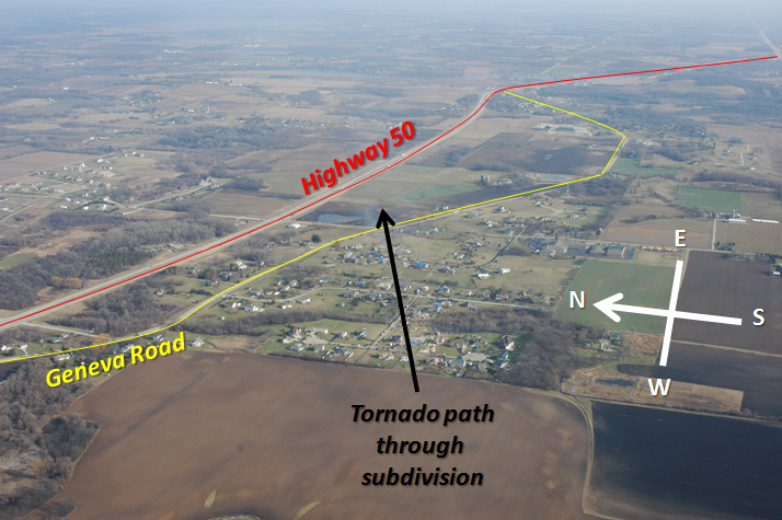
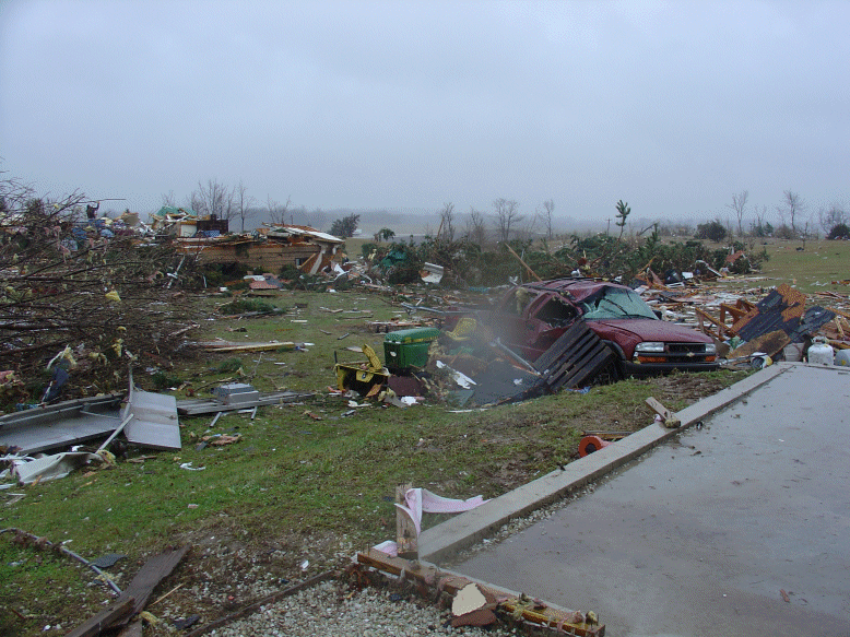
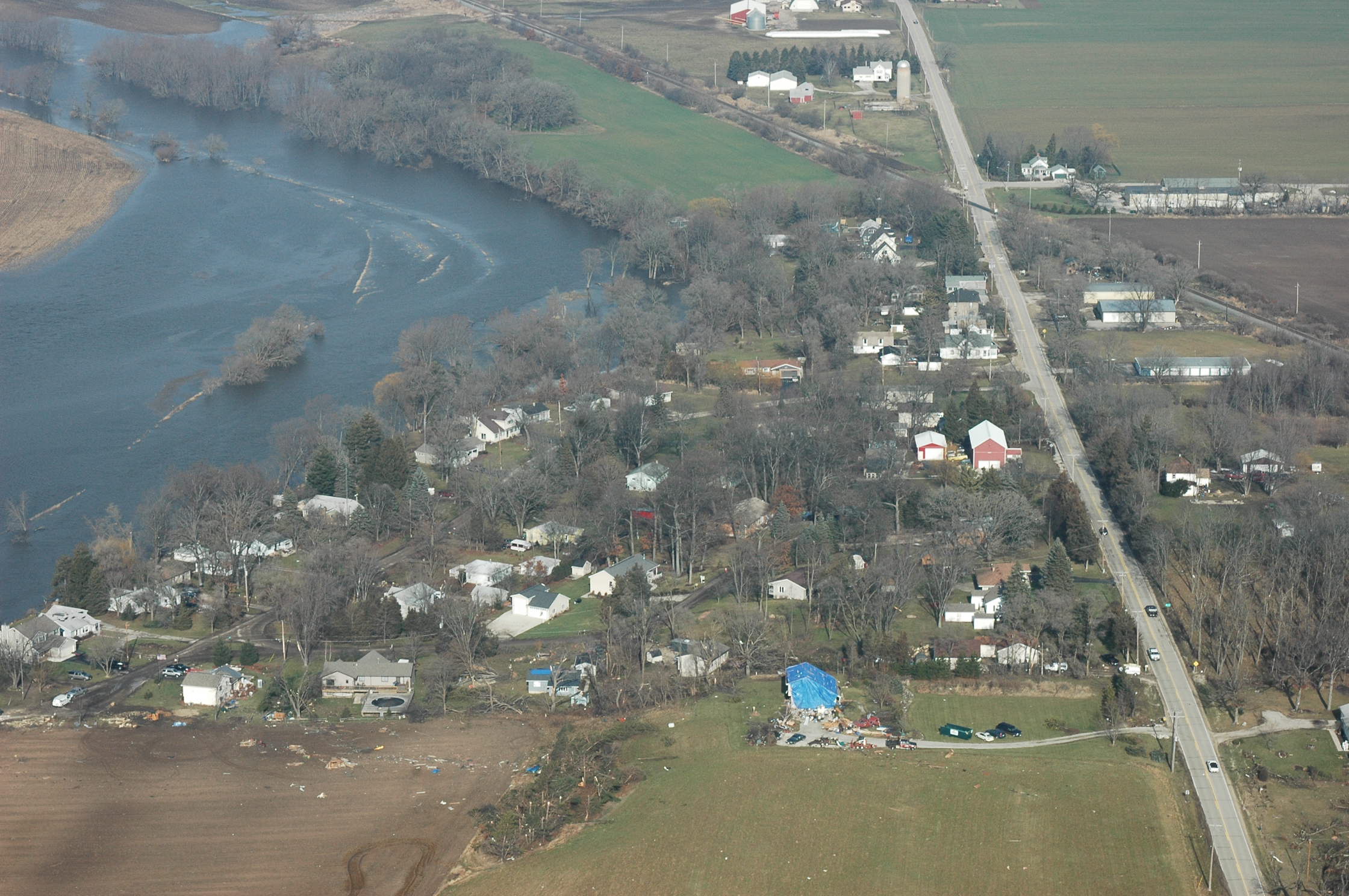
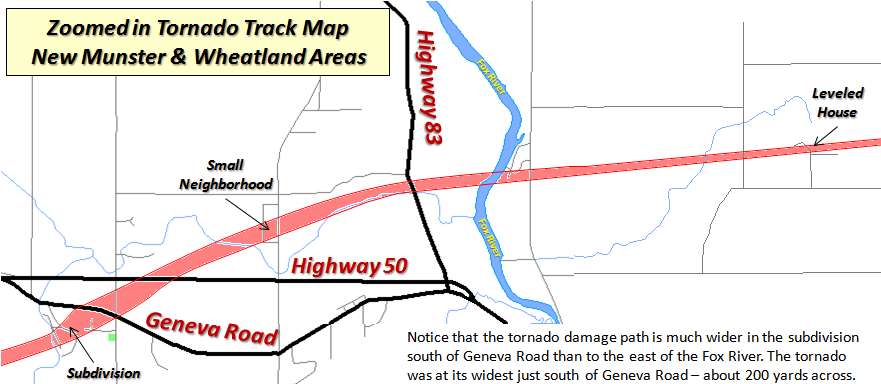
The worst damage observed began in the vicinity of the intersection of County Highway O (368th Avenue) and Highway 50 and continued through the Wheatland area. It was right around Highway 50 that the tornado reached its widest point, a path width of approximately 200 yards, as it tore through a subdivision just south of the highway.
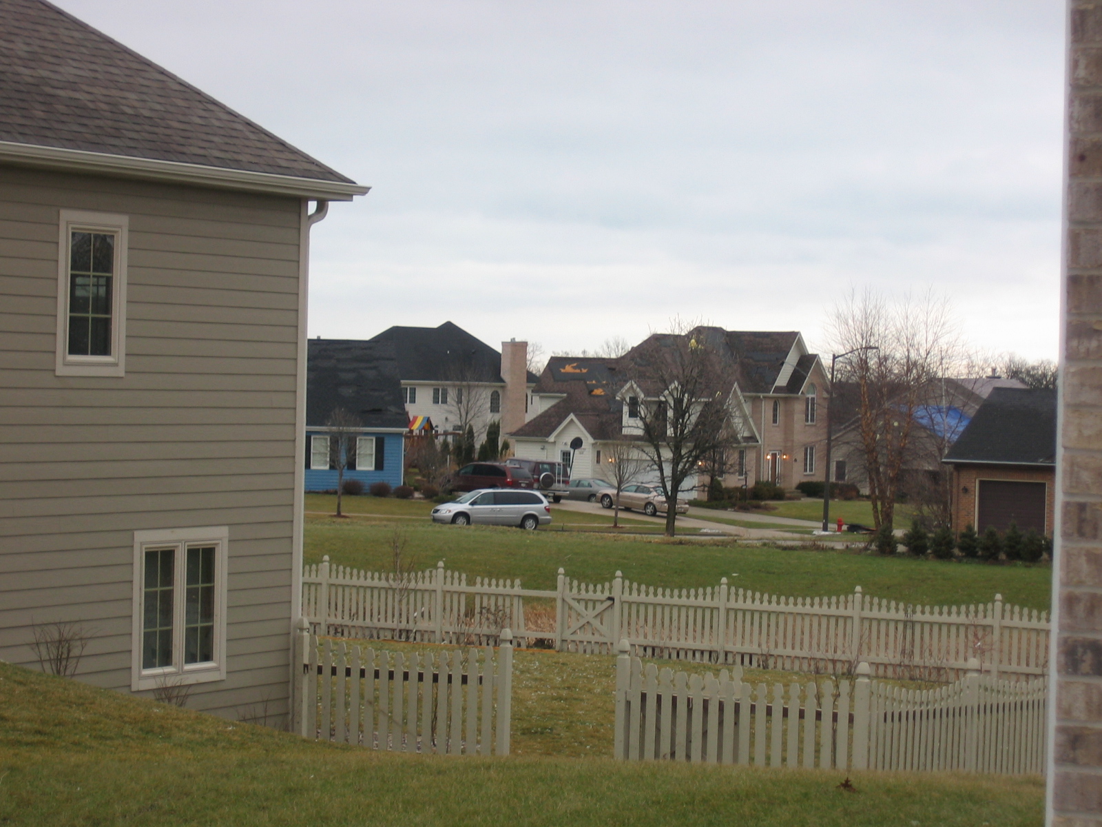
Below are a few aerial photographs taken by the Civil Air Patrol of the damage in this subdivision. Click here for an analyzed picture to orient yourself.


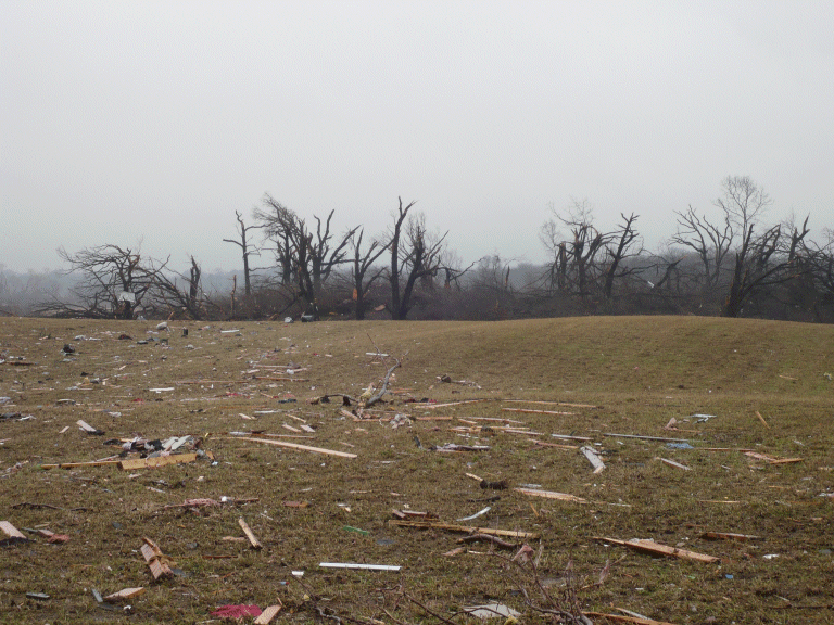
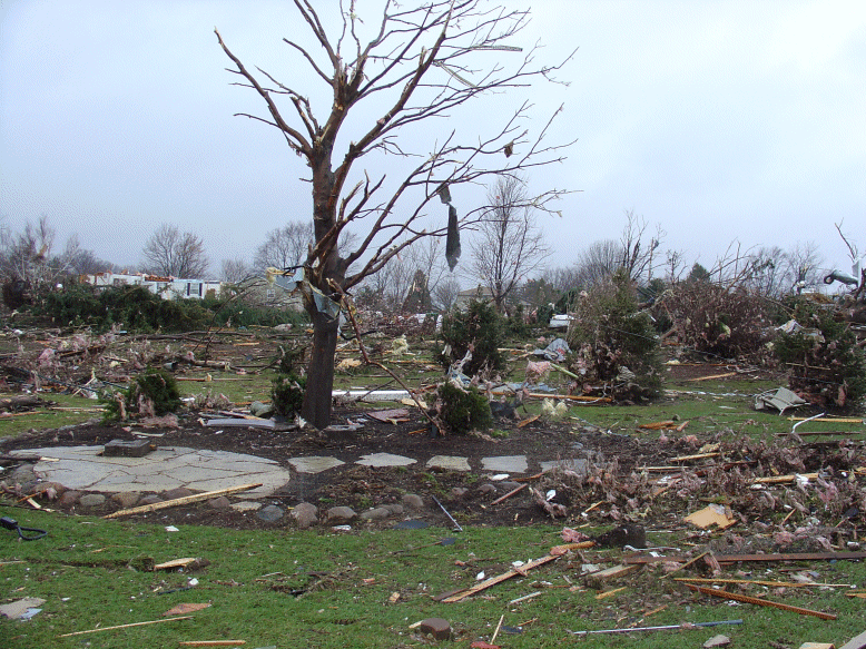
Below are some photographs taken from the ground in the subdivision pictured above.
 |
 |
 |
 |
 |
 |
The tornado continued to move to the northeast, crossing Highway 50, and impacting a small neighborhood shortly thereafter. This neighborhood was along County Highway KD just north of Munster Creek.
Below are a few aerial photographs taken by the Civil Air Patrol of the damage in this small neighborhood. Click here for an analyzed picture to orient yourself.
 |
 |
Below are some photographs taken from the ground in the neighborhood pictured above.


After that, the tornado began to turn more to an easterly direction as it approached the Fox River near 45th Street. There was some damage to homes near the Fox River (click here for an aerial photo) and to some trees and homes further east (click here for an aerial photo). You can also see in the first photo the flooding on the Fox River.
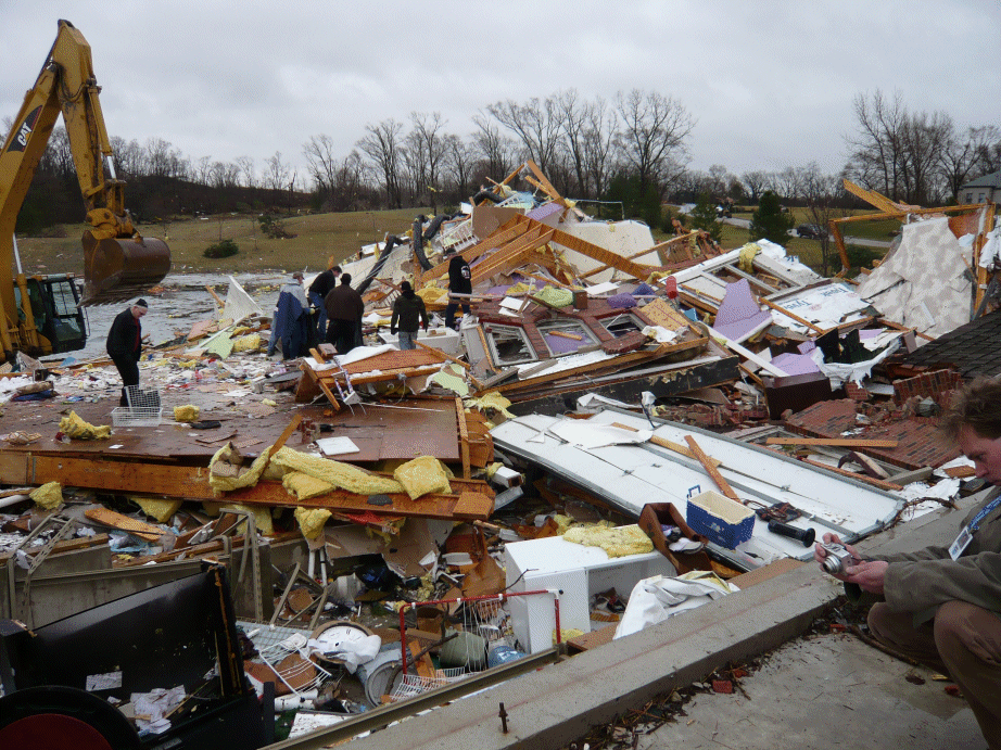
The tornado continued to move to the east, eventually cutting through another small neighborhood near 301st Avenue and 49th Street and severely damaging several homes. The tornado damage path was extremely narrow here, but the damage was quite intense. Despite the narrow tornado path, it managed to strike one house squarely, leveling it.
Below are a few aerial photographs taken by the Civil Air Patrol of the damage in this small neighborhood.
 |
 |
Below are some photographs taken from the ground in the small neighborhood pictured above, particularly of the house that was leveled.


After clearing this small neighborhood, the tornado began to turn back to the east-northeast, causing some sporadic damage along the remainder of its path. The last significant damage was to a barn (click here for an aerial photo) just southeast of the intersection of 41st Street and County Highway B.
For a zoomed in, more detailed map of the part of the tornado path with the most severe damage click here.
The tornado covered a total of 10.8 miles in about 15 minutes, which means that its forward speed would have been, on average, a very fast 43 mph!
Town of Somers & Northern Kenosha Tornado
 BEGINNING     TIME  439 PM
           LOCATION  47TH AVENUE AND 18TH STREET /KENOSHA CO./

 ENDING        TIME  443 PM
           LOCATION  JUST E SHERIDAN RD & 14TH PLACE /KENOSHA CO./

 DURATION            4 MINUTES           EF-SCALE    EF-1
 PATH LENGTH         2.4 MILES           DEATHS      0
 MAX WIDTH           100 YARDS           INJURIES    0
The tornado that affected portions of Eastern Kenosha County, including the town of Somers and northern parts of the city of Kenosha has been given a preliminary rating of EF-1 by the National Weather Service Storm Survey Team. This places the tornadic winds in the 86 mph to 110 mph range.
Information about the EF tornado rating system.
Maximum estimated path width is 75 to 100 yards wide. The initial spin-up point of the tornado appears to be just east of the intersection of 18th Street (County Highway L) and Green Bay Road (Highway 31). The tornado spun up at about 4:39 PM.
The initial spin-up point of the tornado appears to be just east of the intersection of 18th Street (County Highway L) and Green Bay Road (Highway 31). The tornado spun up at about 4:39 pm.
The tornado moved mainly to the east-northeast causing mostly minor damage to homes. There were a few homes with moderate damage, along with some tree and power line damage.
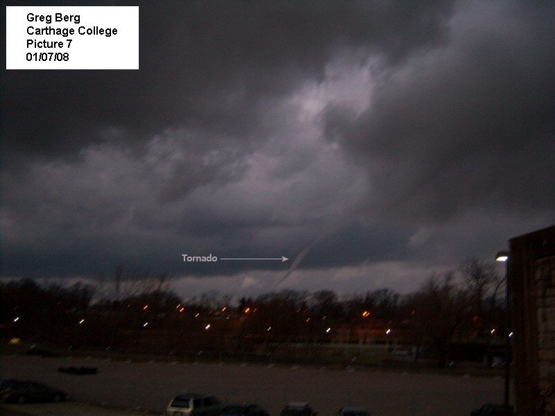
The tornado damage path appeared to terminate just north of the Carthage College Campus at about 4:43 pm. Below is a map of the tornado track.

Below are some damage photographs from the north side of Kenosha.

Radar Images and Weather Maps
Listed below, in a table format, are radar images from this tornado event. Time of the radar image and a brief description of what was occurring at the time are provided. Click on a time in order to view the image.
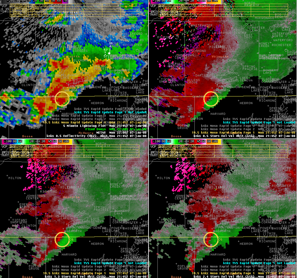
| The supercell when it was producing a tornado over Boone County, Illinois. Viewed from KMKX radar. The tornado at this time was producing EF-3 damage. | |
| The supercell crossing into Walworth County. Viewed from KMKX radar. | |
| The supercell over far Southeast Walworth County. Viewed from KMKX radar. The tornado at this time had been on the ground for one minute. | |
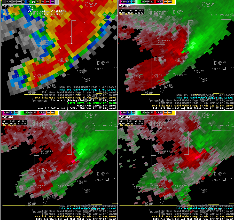
| The tornado approaching the New Munster area and about to produce some of its most significant damage. Viewed from KMKX radar. | |
| The tornado moving through the Wheatland area. Viewed from KMKX radar. | |
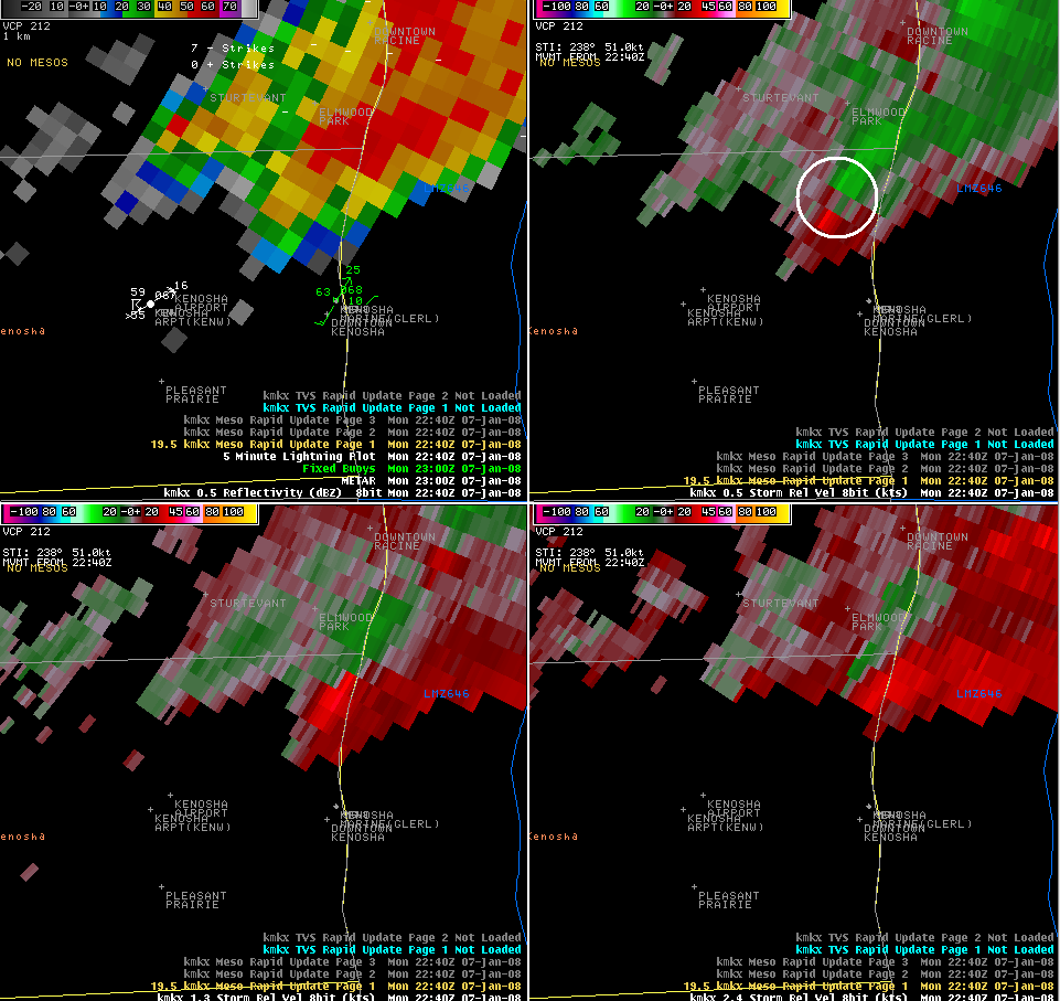
| Well defined hook echo as the storm moves into Northeast Kenosha County. Viewed from the MKE terminal doppler radar in Northern Racine County. | |
| The supercell nearly over Lake Michigan, and producing a tornado at this time. Viewed from KMKX radar. |
Here is a forecast sounding at Milwaukee about an hour before the tornado hit Kenosha County. This sounding is very supportive of severe thunderstorm development, and is much more representative of a mid-summer atmospheric environment than an early winter one.
