|
Waldseemüller’s Map: World 1507
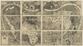 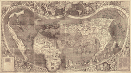
Waldseemüller’s Map: World 1507: About this image
Overview The 1507 World Map by Martin Waldseemüller is one of the world’s most important maps. For the first time, this map labels America and shows the continent as a separate land mass. It is often referred to as America’s Birth Certificate. Students will investigate this map by looking closely at the details of each section of the map and then draw conclusions on the revelation of this new and unusual world to the people of 1507.
| Objectives |
After completing this unit students will be able to:
- Analyze maps as primary sources.
- Locate identifiable land masses.
- Locate standard map features: equator, Tropic of Cancer, Tropic of Capricorn, longitude.
- Explain the historical significance and legacy of this map.
|
| Time Required |
One class period. |
| Recommended Grade Level |
6-8 |
| Topic |
Geography & Maps
Early American Exploration |
| Era |
Three Worlds Meet, Beginnings to 1620 |
| Standards |
McREL 4th Edition Standards & Benchmarks
Geography
- Understands the characteristics and uses of maps, globes and other geographic tools
- Understands how geography is used to interpret the past
Historical Understanding
- Understands and knows how to analyze chronological relationships and patterns
- Understands the historical perspective
U.S. History
- Understands the characteristics of societies in the Americas, Western Europe and Western Africa that increasingly interacted after 1450
|
| Materials Used |
The following materials will be used in this lesson.
|
| Resources Used |
The following resources will be used in this lesson
Library of Congress Resources
|
 Download the Adobe Acrobat Reader Download the Adobe Acrobat Reader
Procedure
Activity One
This project is meant to be an introduction to historical map analysis, but assumes students are familiar with the parts of a map: compass, scale, title, orientation, etc. Before leading students through the exploration process, teachers should make themselves familiar with the background of this map by reading Recognizing and Naming a New Continent and Teacher Notes: Waldseemüller’s Map, World 1507.
- Introduction of Maps. Discuss the parts of a map: compass, scale, title, legend or key, notations. Review types of maps: topographic, political, military, bird’s eye, weather satellite photo, raised relief
- Introduction to Historical Maps. How are they different? Students should think like a historian and ask questions, find possible answers, compare with other maps and documents, consider previous knowledge, reflect on bias or point of view with this source.
- Pass out one section of the map to each student. Have students take a close look at their map section.
- Ask them to share their findings with their partner. What are they noticing? Places, foreign languages, flags? What questions do they have?
- Review analysis sheet. Each student will use the map analysis sheet to answer what they can.
- Have students find another student with the same section and compare what they have found.
- On a large table, assemble the entire map, with each section being described by its pair. What new information is shared from each new piece? Does this piece confirm or eliminate guesses about the map.
- Students will share their findings of each of these map sections with the entire class.
Activity Two
- Pass out Recognizing and Naming a New Continent.
- Have students think about the impact of this map. Discussion.
- Reflect on the final section of the map: “This one request we have to make, that those who are inexperienced and unacquainted with cosmography shall not condemn all this before they have learned what will surely be clearer to them later on, when they have come to understand it.”
- Write a letter to Mr. Waldseemüller asking him questions.
- If possible, allow time for further research with supplemental resources from your library: biographies, non-fiction, reference, on-line resources from the Library of Congress.
- Teachers: Please note that the use of the umlaut (ü) in Waldseemüller is considered the proper spelling, but students should be aware that they may see the name spelled without an umlaut. Students may need to search using both spellings.
Extension
- Create a timeline of the historic events 15 years before this map and 15 years after this map.
- Create a hypothetical narrative of the map makers of the time discussing this new information.
- Propose how the United States history may have evolved differently if this map was not created.
- All nations have laws to protect their antiquities. Why did the German government permit the Waldseemüller Map, World 1507 to come to the Library of Congress?
Evaluation
Teacher observation of collaborative work.
Teacher observation of critical thinking.
Evaluate the student analysis sheets and final questions.
Evaluate the student’s reflection of the Waldseemüller’s final statement.
Evaluate the student’s letter to Mr. Waldseemüller for content, examples and understanding.
|