|
July 14, 2003
Satellites See Lightning Strikes In Ozone's Origins
During summertime ozone near the Earth's surface forms in most major
U.S. cities when sunlight and heat mix with car exhaust and other pollution,
causing health officials to issue "ozone alerts." But in other parts
of the world, such as the tropical Atlantic, this low level ozone appears
to originate naturally in ways that have left scientists puzzled. Now,
NASA-funded scientists using four satellites can tell where low level
ozone pollution comes from and whether it was manmade or natural.
Atmospheric scientist David Edwards and his colleagues from the National
Center for Atmospheric Research (NCAR) and collaborators in Canada and
Europe have studied this problem using satellite data from three NASA
spacecraft, one from the European Space Agency (ESA), and a computer
model from NCAR. They were surprised to find that a greater amount of
near-surface ozone over the tropical Atlantic develops as a result of
lightning instead of agricultural and fossil fuel burning.
Their findings appeared in a recent issue of the American Geophysical
Union's Journal of Geophysical Research Atmospheres. The formation of
ozone involves several factors, such as lightning and pollution from
agricultural and fossil fuel burning, which is why it was helpful to
use NASA's multiple satellites to look at each in turn.
NASA satellites included Terra, the Tropical Rainfall Measuring Mission
(TRMM), and Earth Probe/TOMS. ESA's ERS-2 satellite was also used to
look at ozone, and NCAR's MOZART-2 (Model for OZone And Related chemical
Tracers) computer model was used to simulate the chemical composition
of the atmosphere.
Because the different satellite instruments could detect fires, lightning
flashes, and the resulting pollution and ozone in the atmosphere, respectively,
they provided a bird's-eye global view of what was going on, and the
computer model helped tie all the pieces together.
Fires create smoke and carbon monoxide, and lightning creates nitrogen
oxides (NOx). All of these come together with other unstable compounds
in a chemical soup, and sunlight helps trigger the reaction that helps
form ozone. The scientists found that in the early part of the year,
the intense fires set by farmers for land-clearing and traditional cultivation
in north-western Africa, just south of the Sahara Desert, resulted in
large amounts of pollution that they could track using satellite images
as it spread over the Atlantic towards South America. This pollution
greatly increased ozone at low altitudes near the fires.
However, when Edwards and his colleagues looked at areas of elevated
ozone levels measured by satellites and aircraft over the Atlantic south
of the equator, they were more surprised to find that this ozone was
caused mainly by lightning rather than the fires.
In other parts of the world, especially near cities, ozone near Earth's
surface is often made from pollution as a result of industrial fossil-fuel
burning and cars. Understanding where the pollution comes from in each
case is important for improving our air quality.
NASA's Measurements of Pollution in the Troposphere (MOPITT) instrument
aboard the Terra satellite is a joint NASA/Canadian Space Agency mission
that measured carbon monoxide concentrations at various levels of the
atmosphere. The TOMS instrument on EP/TOMS measured tropical tropospheric
ozone over the mid-Atlantic. The TRMM satellite counted the number of
fires in a region using its Visible/Infrared Scanner (VIRS), and also
catalogued lightning flash data from its Lightning Imaging Sensor (LIS).
The satellite data was then interpreted using the MOZART-2 computer model.
Previously, scientists used TOMS observations to get a general idea
of where the tropospheric ozone levels were high, but it was often difficult
to say where the ozone came from and which pollution source or natural
process led to its creation. Only recently has the 4 satellite combination
enabled scientists to make this distinction.
This research was funded by NASA's Earth Science Enterprise (ESE), in
cooperation with the National Science Foundation, sponsor of NCAR. NASA's
ESE is dedicated to understanding the Earth as an integrated system and
applying Earth System Science to improve prediction of climate, weather
and natural hazards using the unique vantage point of space.
For more information and images on the Internet, visit:
http://www.gsfc.nasa.gov/topstory/2003/0617eyes.html
For information about the satellites and science mentioned above, on
the Internet visit:
European Space Agency's GOME:
http://auc.dfd.dlr.de/GOME/
Terra Satellite:
http://terra.nasa.gov/
TRMM Satellite:
http://trmm.gsfc.nasa.gov/
TOMS Satellite:
http://toms.gsfc.nasa.gov/index.html
MOPITT:
http://www.eos.ucar.edu/mopitt/
U.S. EPA: Ozone: Good Up High, Bad Nearby
http://www.epa.gov/oar/oaqps/gooduphigh/#goodbad
###
Contacts:
Rob Gutro
Goddard Space Flight Center, Greenbelt, Md.
301-286-4044
rgutro@pop900.gsfc.nasa.gov |
|
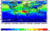
Carbon Monoxide Around the World
This image shows the vertical column of carbon monoxide (CO) for January,
2001, measured by NASA?s Terra satellite. The reds are the highest levels
and blues show the lowest levels.�The white areas have no data due to
clouds. Pollution plumes from agricultural fires over northwestern Africa
extend westward over the Atlantic Ocean. High pollution levels are seen
in the green area from Asia out over the Pacific Ocean. Pollution over
China is mostly from industrial emissions, and this plume sometimes reaches
the U.S. west coast. Image and Caption Credit: David Edwards

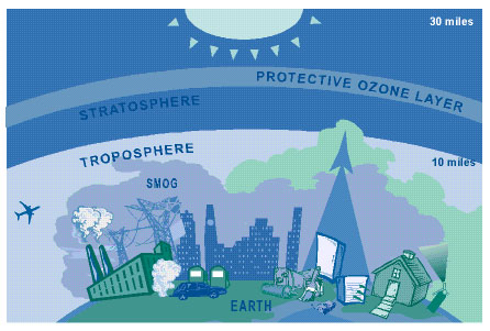
Where Ozone Lives
Ozone is a gas that forms in the atmosphere when 3 atoms of oxygen combine.
At ground level ozone is created by a chemical reaction between sunlight,
oxides of nitrogen, and volatile organic compounds. Ozone has the same
chemical structure whether "good" or "bad," depending on its location
in the atmosphere. Image and Caption Credit: U.S. EPA
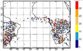
Lightning Flash Rate
This image depicts a mean count of lightning flashes detected by the
TRMM satellite for January, 2001. The lightning activity over southern
Africa and South America produces large amounts of chemicals in the atmosphere
that lead to low level ozone formation. The prevailing winds then deposit
this ozone over the southern tropical Atlantic. Red indicates 30 flashes
per hour, dark blue 5 per hour. Image Credit: David Edwards

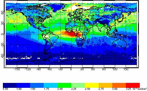
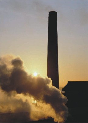
Carbon Monoxide from Burning Vegetation & Fossil Fuels
Carbon monoxide is a good tracer of low level ozone pollution since it
is produced by incomplete combustion processes such as the burning of
fossil fuels in urban and industrial areas, the use of biofuels in developing
countries, and by biomass burning in the tropics. Vegetation Image Credit:
NASA Smokestack Image Credit: Energy Information Admin., U.S. Dept. of
Energy

High-Resolution
Image
|


