|
June 26, 2002
MIXED CROPLANDS MAY MAKE SOME AREAS COOLER, WETTER IN SUMMER
The variety of the vegetation and crops
in the Great Plains and Rocky Mountain
states has helped maintain a cooler,
wetter climate, according to a
NASA-funded study using a computer
climate model.
Hydrometeorologists Jim Shuttleworth at
the University of Arizona, Tucson, Ariz.,
and Lixin Lu at Colorado State
University, Fort Collins, Colo., found that
when they introduced satellite
measurements of the real patterns of vegetation in Great Plains and Rocky
Mountain states into a computer model, the results generated extra convection in
the atmosphere to give a cooler, wetter climate.
The study appears in the June issue of the Journal of Hydrometeorology.
Mixed vegetation impacts the
atmosphere, weather and climate
through the proportion of sunlight that
gets reflected from the land and leaves
back out to space, the varying heights
of trees and other plants exposed to
the wind, and the effectiveness of
different plant types when it comes to
evaporating water.
For example, irrigated, lush crop lands
with plenty of water in the soil warm the
air less because they use more of the
Sun's energy for evaporation, as compared to hot, dry bare soil. Along with
differing temperatures, the varied heights of plants and trees in a region change
the aerodynamics of the atmosphere, creating more circulation and rising air.
When the rising air reaches the dewpoint in the cooler, upper atmosphere, it
condenses into water droplets and forms clouds.
"The mixed vegetation creates areas of
different temperatures next to each
other, some warmer and some colder,
and this leads to mixing in the
atmosphere that gives rise to clouds
and, ultimately, rain," Shuttleworth said.
Over the last two decades, detailed
maps of the amount and type of
vegetation that covers the ground have
become available through remote
sensing. Based on that information,
scientists can enter data to describe
vegetation into computer models that simulate regional climate.
In this study, a climate version of the Regional Atmospheric Modeling System
(ClimRAMS) was used to explore whether more of a mix of vegetation can alter
climate in the United States. The ClimRAMS model simulated the whole of the
country with a grid scale of 200 km (124 miles), but it focused particularly on
predicting climate with a grid scale of 50 km (or 31 miles) in a rectangular area of
the Great Plains and Rocky Mountains.
A U.S. Department of Agriculture soil
database was used to define different
soil types in the climate model, and
vegetation was classified using an
international land-cover system.
Vegetation and land cover types
included: mixed crops, short grass,
evergreen needleleaf trees, deciduous
broadleaf trees, tall grass, desert,
tundra, irrigated crop, semi-desert,
shrub evergreen, mixed woodland and
inland water.
The ClimRAMS normally assumes there is little difference between grasslands in
northern Wyoming and southern Kansas, for instance, but the researchers found
that when they introduced satellite measurements of "leaf area index" (a way of
quantifying how much vegetation is actually present), the more realistic pattern of
vegetation generated extra convection in the atmosphere to give a cooler, wetter
climate.
Shuttleworth and Lu used satellite plant cover data from Kansas, Nebraska,
South Dakota, Wyoming and Colorado for their computer model runs.
Computer model simulations of the growing season that included satellite data of
mixed vegetation showed lower maximum and minimum temperatures in the
region, compared to a model run that contained less detail of plant cover. Over
the entire year, simulated precipitation levels were on average two-thirds of a
millimeter per day more for the model using mixed vegetation, which may account
for the cooler temperatures found during the growing season.
In general, most current computer models that predict Earth's future climate do
not account for the complex mix of vegetation and its atmospheric impacts, and
may be producing forecasts that are too dry and too warm during growing
seasons.
"In the future, it will be important to use remote sensing data to enter the fine
details of plant cover into computer models to get more accurate weather and
climate forecasts," Shuttleworth said. Further, more research is needed to
determine if increasing variety of croplands would help lessen drought conditions.
This research was funded by the NASA Land Surface Hydrology Program.
###
Contacts:
Cynthia
M. O'Carroll
Goddard Space Flight Center, Greenbelt, Md.
Phone: 805/605-3051
Krishna Ramanujan
Goddard Space Flight Center, Greenbelt, Md.
(Phone: 301/286-3026)
|
|

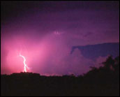 Rain Storms in the Great Plains
Could development have lessened droughts?
Perhaps so, computer models predict that
mixed farm cropping (varying the vegetation)
in the Great Plains helps maintain a cooler,
wetter climate. Image Credit: Mike Phelps,
Storm Photographer
 Focus on the Great Plains
In this study, a climate version of the
Regional Atmospheric Modeling System
(ClimRAMS) was used to explore whether
changes in vegetation distribution can alter
climate in the United States. The ClimRAMS
model simulated the whole of the country with
a grid scale of 200 km, but it focused
particularly on predicting climate with a grid
scale of 50 km (or 31 miles) in a rectangular
area of the Great Plains and Rocky
Mountains. Image Credit: Jim Shuttleworth,
University of Arizona
 Mapping Soil and Vegetation in the Model
The United
States Department of Agriculture STATSGO
soil data base was used to define different soil
types in the model, while vegetation were
classified using the International
Geosphere-Biosphere Programme (IGBP)
land-cover classification into mixed crops,
short grass, evergreen needleleaf trees,
deciduous broadleaf trees, tall grass, desert,
tundra, irrigated crop, semi-desert, shrub
evergreen, mixed woodland and inland water.
The ClimRAMS normally assumes there is little
difference between grasslands in northern
Wyoming and southern Kansas, for instance,
but the researchers found that when they
introduced satellite measurements of "leaf
area index" (a way of quantifying how much
vegetation is actually present), the more
realistic pattern of vegetation generated extra
convection in the atmosphere to give a cooler,
wetter climate.Image Credit: Jim Shuttleworth,
University of Arizona
|


