|
March 9, 2004
Scientists Find More Keys to the North
Pacific Ocean’s Climate
Using satellite and other data, scientists
have discovered that sea surface temperatures and
sea level pressure in the North Pacific have
undergone unusual changes over the last five
years. These changes to the North Pacific Ocean
climate system are different from those that
dominated for the past 50-80 years, which has led
scientists to conclude that there is more than
one key to the climate of that region than
previously thought.
According to a study by Nicholas Bond, J.E.
Overland and P. Stabeno of the National Oceanic
and Atmospheric Administration (NOAA) Pacific
Marine Environmental Laboratory, and M. Spillane
of the University of Washington, during the last
four winters from 1999-2002 (ranging from
November to March) sea surface temperatures were
cooler than normal along the U.S. west coast and
warmer than normal in the coastal Gulf of Alaska.
These conditions differ from those of the Pacific
Decadal Oscillation (PDO), thought to be the
primary key that causes the climate of the North
Pacific to change. As a result, the scientists
believe that the conditions that have occurred
since 1999 are independent of the PDO.
The Pacific Decadal Oscillation is a
basin-wide oceanic pattern similar to El
Niño and La Niña but much larger.
It lasts a couple of decades rather than a year
or less like El Niño and La Niña.
According to Bond, the unusual levels of pressure
and temperature seen in the last five years are a
departure from the pattern seen in the PDO, which
represented the principal mode of long-term
climate variability in the North Pacific for the
20th century. These results show that
a single index such as the PDO is incomplete for
characterizing the state of the North Pacific
climate system.
“Looking back over the past century,
categorizing the climate signals as a pure PDO
pattern would be simple-minded,” said Bill
Patzert, Oceanographer and Climatologist at
NASA’s Jet Propulsion Laboratory, Pasadena,
Calif. “This research shows that although
there are some characteristics of a PDO, there
are some disturbances in the ‘PDO
force,’ as the study showed using sea
surface temperature and sea level pressure,
Patzert noted. A good example is that some areas
of North America are responding in a PDO-like
response, and other places like Western Canada
and Alaska are not experiencing cooler air
temperatures expected from a simple PDO
shift.
Patzert praised his colleagues and noted that
the lesson is that these climate patterns are
constantly shifting, so Bond and Stabeno have
reminded scientists that the decadal shifts in
climate are not clean and simple.
The change throughout the last five years in the
North Pacific climate may also be having
considerable impacts on the marine ecosystem. For
example, during the recent period, ocean
conditions were favorable to salmon and allowed
them to return in greater numbers and reproduce
more. In a classic PDO scenario, the salmon
fisheries would collapse in Alaska and boom in
Pacific Northwest, but they’re booming in
both places.
“During the winters from 1999 through
2002 the North Pacific Ocean was subject to
unusually or anomalously low sea level pressure
in the Bering Sea and anomalously high sea level
pressure north of Hawaii,” Bond said. Sea
level pressure is the weight of the air pressing
down at sea level, and is on average 14.7 pounds
per square inch. “At the same time, a broad
band of unusually warm water extended eastward
from the coast of China and a band of unusually
cold water curved from off the coast of the lower
48 to north of Japan,” he said.
“The best sea surface temperature data
we get are from satellites. We couldn’t do
this kind of research with ships and buoys,
because they just don’t have that kind of
coverage,” Bond said. “The bottom
line is not to take your “satellite”
eye off the climate system, because it’s
very changeable,” Patzert said.
Bond used NOAA’s National Center for
Environmental Prediction analysis of sea surface
temperatures. Those temperatures are derived from
the Polar Operational Environmental Satellite
system, of which NASA’s Goddard Space
Flight Center is responsible for their
construction, integration, and launch.
“In the future, NOAA plans to include in
their analysis, sea surface temperature data from
NASA’s Tropical Rainfall Measuring Mission
satellite (TRMM), and the Aqua satellite’s
Advanced Microwave Radiometer and Moderate
Resolution Imaging Spectroradiometer
instruments,” said Richard Reynolds,
research oceanographer with NOAA’s National
Climatic Data Center.
This research was supported by NASA, NOAA, and
the National Science Foundation. NASA’s
Earth Science Enterprise mission is to develop a
scientific understanding of the Earth system and
its response to natural or human-induced changes
to enable improved prediction capability for
climate, weather, and natural hazards. Part of
NOAA’s mission is to describe and predict
changes in the Earth’s environment.
The study appears in a recent issue of Geophysical Research Letters.
###
Contacts:
Rob Gutro
NASA Goddard Space Flight Center, Greenbelt,
Md.
Phone: 301/286-4044
Alan Buis
Jet Propulsion Laboratory, Pasadena, Calif.
Phone: 818/354-0474
alan.d.buis@jpl.nasa.gov
Jana Goldman
NOAA Public Affairs, Silver Spring, Md.
Phone: 301/713-2483 ext.181
|
|

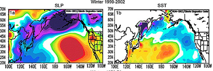
Unusual Sea Level Pressure And Surface
Temperatures
Depicted are averages of sea level pressures
(left) and sea surface temperatures (right)
during the winters of 1999-2002. In the left
image, the North Pacific Ocean was subject to
unusually low sea level pressure (blue) in the
Bering Sea and anomalously high sea level
pressure north of Hawaii (yellow/red). In the
right-hand image, there were cooler (blue) than
normal sea surface temperatures (SSTs) along the
U.S. west coast, and warmer (yellow/orange) than
normal SSTs in the coastal Gulf of Alaska.
CREDIT: NOAA/NCEP, Univ. of Washington
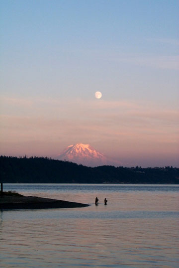
Salmon Fishing in Washington
State
The change throughout the last 5 years in the
North Pacific climate created favorable ocean
conditions for salmon and allowed them to return
in greater numbers and reproduce more. This is a
picture of Gig Harbor, Washington state, taken in
2000. CREDIT: NOAA photo library, Carol Baldwin,
NOAA OMAO
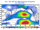
No PDO in the Wind During Winters
1999-2002
This pattern of unusual winds is different from
those associated with the Pacific Decadal
Oscillation (PDO), El Niño, or La
Niña. This composite of the years
1999-2002 shows an unusually strong westerly jet
stream around 30,000 feet, (yellow and red areas
are strong winds) at 45°N in the eastern North
Pacific. CREDIT: University of Washington
|