|
August 27, 2004
NASA SATELLITES ALLOW USDA TO SEE WORLD’S LAKES RISE AND FALL
A few NASA satellites designed to study heights of Earth’s ocean surfaces are now also coming in handy for tracking water levels of
inland lakes and reservoirs.
When analysts at the United States Department of Agriculture (USDA) Foreign Agriculture Service (FAS) learned that NASA satellites could be used
for measuring lake water heights, they saw a chance to get vital information for managing irrigation and forecasting crop production in out-of-the
way places.
Since early this year, NASA has supplied the USDA with near-real time data on lake and reservoir heights from around the world. The USDA has
posted this information on a web site that allows users with a computer and Internet to access it for their varied uses. Analysts who forecast crop
production, scientists, in-country water and irrigation managers, those involved in fishing industries, and the general public have all been making
use of the site.
NASA and the French space agency Le Centre National d’Etudes Spatiales (CNES) teamed up to design, build and launch the TOPEX/Poseidon and the
Jason-1 satellites. These satellites were designed to study many aspects of the ocean. The TOPEX/Poseidon satellite, for example, orbits at a height
of 1336 kilometers (830 miles) above Earth, and can measure the height of the ocean surface directly underneath the satellite with an accuracy of 4-5
centimeters (better than 2 inches). Jason-1 and TOPEX/Poseidon cover the global oceans every 10 days. With these capabilities, this technology is
surprisingly valuable for looking at larger areas of inland water.
“The satellites were designed with oceanographic objectives in mind, so the fact that they can be used for lakes and rivers are an added
bonus,” said Charon Birkett, a University of Maryland researcher based at NASA’s Goddard Space Flight Center in Greenbelt, Md. It was
Birkett’s work with satellites and inland water sources that caught the USDA’s interest.
Water level data for many lakes can be hard to get. Lakes may be located within inhospitable regions. Terrain may make it hard to install water
level gauges, or some countries may not have the money for proper equipment. Even if there is equipment, someone must be available to regularly
record the measurements. For an international agency like the USDA FAS, information on water levels in remote lakes in Africa or Asia, for example,
may only be possible if a researcher happens to be passing by the area.
“Now we have this dataset which gives you a global picture of irrigation capabilities,” said Brad Doorn, Remote Sensing Technical
Coordinator for the FAS. “It’s very much a night and day perspective as it relates to global irrigation potential.”
NASA/CNES satellites fly over 350 of the world’s largest lakes. The USDA decided to focus on about 150 of those that are important for
agriculture. Of those, about 70 are currently online, with more being regularly added as Birkett and co-worker, Brian Beckley, from Raytheon’s
Information Technology and Scientific Services (ITSS) team learn to extract information on the smaller lakes. Fifteen of the lakes that are currently
online are in Africa.
The records begin with archived data from TOPEX/Poseidon, launched in 1992. They continued with data from the Jason-1 satellite, launched in
December 2001. The two stayed in the same orbit for about 7 months, before the TOPEX/Poseidon satellite’s orbit was changed. These months of
cross-over data were crucial for validating each of the satellites and for making sure the data records from Jason-1 were compatible with the
TOPEX/Poseidon archive.
The information provided by the satellites, and made public through the web site, is a blessing to those who manage water for irrigation.
Irrigated areas generally have less rainfall, and therefore crops in these drier regions are dependent on stores of water, like lakes, reservoirs and
rivers.
The FAS analyzes crop production around the world. They regularly use computer models that simulate agricultural production based on inputs that
include weather information. In this way they can examine global crop conditions and production. But in irrigated areas that are not rain fed, these
methods are limited. For irrigated areas, you have to be able to determine how much water is actually stored, after seasonal precipitation
passes.
“Satellite records of lake and reservoir water levels give you a good indication of whether there is going to be a systematic or major
problem in water supply,” said Doorn. “If water is low, there may be problems for agricultural production.” This type of
information is especially important for food aid partners, who must budget ahead for how much and where food aid is distributed.
Lake Tharthar in Central Iraq provides irrigation water to areas downstream. It is also linked to the Tigris and Euphrates Rivers. A drought that
carried over many years severely cut grain output between 1999 and 2001. But since then, rainfall has increased, allowing grain production to recover
and even surpass pre-drought levels. Knowledge of water levels in a region like this is crucial for the people who divvy out water for irrigation,
and
for those who plan aid.
The satellites have noticed some striking changes in lake levels around the world. In Iran, Lake Urmia has steadily decreased over the last 5
years. Also, between 1999 and 2001, Lake Hamoun in Iran near the Afghanistan border all but dried up and disappeared. By May 2003, water had returned
to the lake. In that same time period, Lake Michigan levels have also declined.
On the other hand, when there is plenty of water, irrigation managers and farmers can assess the potential for more agriculture. When Caspian Sea
levels rose in 1994, spill-over created a reservoir where little water existed before. As a result, the Kara Bogaz reservoir that borders the Caspian
Sea was once largely desert and is now a large inland water body. Lake Nasser in Egypt also exists in a desert area where water supplies have
increased.
As can be seen, the new technology allows researchers to get water level records regularly, globally, and in places where it is very hard to
maintain or even acquire measurements. At the same time, there are also some limitations to the technology. For example, lake elevations can only be
obtained during the lifetime of the satellite mission. Also, a satellite must pass directly over a lake for the radar to record water heights. But
since the primary mission of these satellites is for studying the oceans, the fixed satellite orbit is determined by the community of oceanographers.
That means people studying inland water have less input into the lakes that are monitored. In addition, some water bodies are simply too small for
the
instruments to pick up. These factors limit the number of observable lakes. “Sometimes, the lake that you want information about is the one you
can’t get,” said Doorn.
Despite the current limitations, users like the FAS are thrilled to have access to the technology. Their web site provides new measurements to the
public about a week to ten days after the satellite passes over.
“When USDA approached us, we told them the satellite record is not as accurate as a gauge sitting in a lake, but we can get good information
within one to two weeks for many lakes in data-poor regions such as Africa and Asia,” said Birkett.
“It’s been a great USDA and NASA cooperative effort,” said Doorn. “It’s exactly what we needed and the type of
cooperation provided has made it a real win-win situation.”
The project has been a collaborative effort between the NASA GSFC, USDA FAS, the University of Maryland, and Raytheon ITSS. The project was funded
by the USDA/FAS.
###
Contact:
Krishna Ramanujan
Goddard Space Flight Center, Greenbelt, Md.
Phone: 607/273-2561
|
|

Time Series of Water in Lake Hamoun, Iran/Afghanistan
Between 1999 and 2001, Lake Hamoun in Iran near the Afghanistan border all but dried up and disappeared. By May 2003, water had returned to the
lake. These three images show a time series of changes to the lake. The images from left to right are from August 1999, May 2001, and May 2003.
Credit: Landsat 7 +ETM sensor extracted at 240m resolution from http://glovis.usgs.gov managed
by Eros Data Center, USGS.
High-Resolution Image of August 1999
High-Resolution Image of May 2001
High-Resolution Image of May 2003
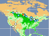
Global Reservoir and Lake Elevation Database
This map shows close to 100 lakes around the world whose water levels are routinely monitored through this collaboration between U.S. Department of
Agriculture’s Foreign Agricultural Service (USDA-FAS), NASA, and the University of Maryland. By clicking on the map, users can go directly to the
USDA database and see detailed information on lake level heights for each of the lakes. Credit: USDA Reservoir Database

Lake Level Variations for Lake Tharthar, Iraq
The graph illustrates the effects of a multiple-year drought (1999-2001) and the subsequent return to more favorable climatic conditions. The
lake’s levels declined steadily in the 1990s, and have risen since 2002. Changes in the lake heights were measured in meters (3.28 feet). Lake
height levels were computed from TOPEX/POSEIDON (in blue) and Jason-1 (in red) data. Credit: USDA Reservoir Database

Lake Level Variations for Lake Tharthar, Iraq
This image shows the path (depicted by series of points) of the Jason-1 satelite along its orbit. The base map image of Lake Tharthar was taken in
1990 by Landsat 5. Credit: NASA Landsat-5 satellite. The data set was produced by the Earth Satellite Corporation for NASA.
High-Resolution Image

Lake Level Variations for Lake Michigan, USA
The graph illustrates a steady decline in Lake Michigan’s water height since late 1997. Lake height levels were computed from TOPEX/POSEIDON
(in blue) and Jason-1 (in red) data. Credit: USDA Reservoir Database

Lake Level Variations for Lake Michigan, USA
his image shows the path (depicted by series of points) of the Jason-1 satelite along its orbit. The base map image of Lake Michigan was taken in
1990 by Landsat 5. Credit: NASA Landsat-5 satellite. The data set was produced by the Earth Satellite Corporation for NASA.
High-Resolution Image

Lake Level Variations for Lake Kara Bogaz, Turkmenistan
When Caspian Sea levels rose in early 1990s, spill-over created a reservoir where little water existed before. As a result, the Kara Bogaz
reservoir that borders the Caspian Sea was once largely desert and is now a large inland water body. Changes in the lake heights were measured in
meters (3.28 feet). Lake height levels were computed from TOPEX/POSEIDON (in blue) and Jason-1 (in red) data. Credit: USDA Reservoir Database

Lake Level Variations for Lake Kara Bogaz, Turkmenistan
This image shows the path (depicted by series of points) of the Jason-1 satelite along its orbit. The base map image of Lake Kara Bogaz was taken
in 1990 by Landsat 5. Credit: NASA Landsat-5 satellite. The data set was produced by the Earth Satellite Corporation for NASA
High-Resolution Image
|


